To see what is really going on it is useful to view a 5-day running average of the upper level charts. Such an approach removes some of the transient, high-frequency disturbances so one can view the underlying, slower-changing, atmospheric circulation. Let me show you such charts, starting a week ago and going forward a week...you will see a ridge over us--varying in strength for sure---but a ridge nevertheless. The shading shows you the differences between the upper level flow (500 hPa--roughly 18,000 ft above the surface) at that time and the 5-day average (anomalies)--but you need not be concerned with them for this discussion. Here they are--the ridge (the height lines deflected to the north over us-- just doesn't go away!


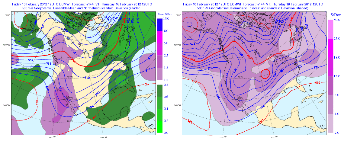
The most skillful long-term guidance is that of the European Center ensembles. Here is the ensemble forecast (left panel) and their single superhigh resolution prediction (right panel) for next Thursday......same story....the ridge, albeit a modest one.
With ridging we will see less storminess, intermittent light rain at most, no snowstorms--pretty benign pattern. I see this pattern next weekend, I am going to start preparing my vegetable garden...spring planting time will be here for the early start plants. And the city of Seattle DOT folks will be able to relax.
Northwest Weather Workshop. This is major local meeting for weather professionals and enthusiasts. All are welcome. March 2-3 in Seattle. Info here on the meeting and registration. The banquet speaker on Friday night will be Andy Wappler of Puget Sound Energy.


The crocii are beginning to croc up here on QA Hill. Some daffies as well...
ReplyDelete".. can't tell you. I asked this question at a department seminar of a real expert on the subject--he didn't know either! " — With this idea, it would appear leastwise, to follow, that a fair amount is still not [yet] known about what steers the atmosphere. Or perhaps better said, colder air mass, both movement together with distribution within it. Warmer being generally more stationary.
ReplyDeleteI appreciate your modesty Cliff. This winter has been a real bore and disappointment. Thats just an opinion from a weather nerd.
ReplyDeleteBut at least you folks in Seattle and NW Washington have been on the edge of interesting weather. Here in E. Wash, Portland south, especially N. California, nothing all season. It could be worse though.
And I actually disagree with ya. Considering what has been, I thought tonights EURO extended looked more like La Nina than all season.
I'm a gambling man. Who wants to bet that March's average temperature will be lower than this months average. Any takers?
ReplyDeleteIm falling deathly ill in believing it might be another 7in rainfall March and 50 degree April.
I kind of have to agree with Smokejumper. Although the models are definitely showing the ridge returning this week. The extended range on the GFS is consistently showing at least something La Nina-like the weekend of the 25th. It obviously keeps shifting exactly how interesting its going to be, but it looks like a decent sized trough could hit us. This morning's runs are very promising for low snow levels that weekend. I just hope things stay on track.
ReplyDeleteI will definitely be keeping an eye on that weekend as we get closer.
Buddy...there is essentially no skill at all out that far. I am a great believe in the 120 hr (5 day rule)...don't get excited by anything farther out than that. And skill really fades out after 7 days. Fun to look at, but not very useful...cliff
ReplyDeleteOh I agree. I'm sorry if it seemed like I put a lot of trust in the models that far out. Its more like it piques my curiosity. If you look at my blog I very rarely discuss anything beyond 180h. The only time I can really remember doing so recently was last week when I discussed the possible longevity of the ridge.
ReplyDeleteI only did that to simply show how persistent the ridge would be, although I might have done a better job explaining how much that could change.
I am very much aware how much things will change in the models as we get closer. Heck, even looking at a strong trough 180 hours out I expect it to (typically) weaken in the models as it gets below that 120h threshold you mentioned. I don't know why, it just seems to be the models' (GFS and NOGAPS) tendency to initially forecast very large troughs and then gradually weaken them down to what we actually see, at least for this winter that's been the case.
this weather reminds me very much of the weather we had during the 2010 Olympics. I'm holding out for snow events in the mountains starting in March and continuing well into May.
ReplyDeleteThe Farmers Almanac says: "Mar 1-4: Rain and wet snow, cool; "
ReplyDeleteThis is for the Kirkland area.
I understand I'm about to make a pretty anecdotal observation, but here goes. I have a Plum tree that for 12 years bloomed in early to mid February...the past two years with cold, late Springs it hasn't bloomed until March. Looking at the bud development today, it's another March kinda year. I really hope the Plum tree is wrong!
ReplyDeleteYou're forgetting about the 2012 Frognostication...
ReplyDelete