First, lets consider climatology. January is the the month with the greatest snowfall over the NW lowlands, but we still can get significant snow in February (like last year!). The snow season really is over after the first in March...although we have gotten some light amounts that rapidly melted into April. Here is the average and extreme snow amounts for Seattle-Tacoma Airport to illustrate. There has been a few events the first week of March for some reason. In two weeks, the chance are we can move on to other things...like killing moss in our lawns.
The classic snow pattern is associated with a big ridge over the eastern Pacific and a sharp trough moving southeastward down the coast. Here is an example:
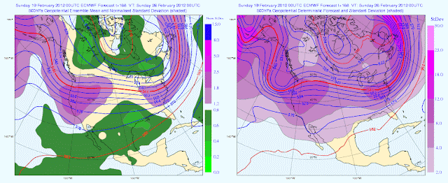
Lets start with the upper level charts from the gold standard of the long-range prediction models--the European Center (ECMWF) global model--for Sunday and Monday. The left panels show the ensemble forecast means and the right the single high-res deterministic run (both at 500 hPa). Remember, ensemble prediction is based on making many forecast simulations, with mean of the ensemble members tending to be more skillful than any particular forecast.
You see we are in the "neighborhood" but the color shading (which indicates the differences amount the model runs used in the ensembles) indicates considerable uncertainty.
Here is the UW WRF output for early Saturday (remember the UW model is driven by the National Weather Service GFS model). Close, but not quite perfect (a little too much over the water).
Here is the average of the NWS GFS ensemble for 500 hPa and the variability amount the members (shading). Lots of variability and thus uncertainty, but the general pattern is close enough to worry
Another way of looking at the uncertainty is using "spaghetti" diagrams, in which we show two height lines from each ensemble member. Here is the staring point of today's ensemble run: the members are almost identical...but not quite!
Here is the120 hour forecast. Now you see why we call it a spaghetti diagram. Lots of differences in the position and amplitude of that trough!
The bottom line: there is a good chance we will get colder at the end of the week but we must wait a few days to have a good idea what will happen. I expect the mountains to do well. Lowland snow is a possibility, but far, far from certain. Local DOTs should stock up on salt/deicer and make sure their drivers are well rested. Stay tuned.
And a reminder that next Friday and Saturday is the NW Weather Workshop...you can still register. See information on the right of this blog. You will never see so many local meteorologists and weather fans in one room. We would be one excited group if it were snowing outside during the meeting.
PS: There has been 2-3 feet in the Cascades during the past day, with the heaviest snows downstream of the convergence zone last night. Here is the 48 hr precipitation from Rainwatch..multiply by ten to roughly get the snowfall totals (you can't believe the total over the mountains, but you get the idea)
Major avalanche risk and several people have apparently died in avalanches today in backcountry areas. Extreme caution is advised.


Just read Paul Deanno's forcast on KOMO....he says that the rest of this month (after Wednesday) will be cooler than normal and long range forcasts call for the beginning of March temps to be much cooler than normal...oh yay! Another "no spring" year.....ugh! I do love winter, but I also love my spring too.....and summer, and fall. Even I am getting tired of the seasons just blending together....
ReplyDelete@ILoveWinter,
ReplyDeleteWhile I agree that the idea of "no spring" is kind of a bummer, I think its too soon to tell. Especially when Early March isn't exactly spring yet. If I start seeing the cold pattern continue into late March and early April then I might start to worry.
Think of this as one last chance of winter weather before Spring comes calling.
In the near term, the latest 6-10 (especially) & 8-14 day outlooks look pretty cold and wet (http://www.cpc.ncep.noaa.gov/). Of course, the big caveat is that at "this time of year" (late Feb / early March) will it really be cold enough for lowland snow accumulation?
ReplyDeleteAnd in the longer term, sadly, the same main forecast page is calling for cooler and wetter than average conditions from March through May in western WA. OH for a decent spring around here! . . .
Cliff, something I've wondered for a while now...Why is the European Center global model the gold standard of long-range predictions, and why don't we have the same modeling system (...?...not sure of the correct terminology there)? Thanks for the info!
ReplyDelete