The pressure different across the mountains has grown to roughly 9 mb and downslope winds along the western Cascade slopes have increased. Gust of 70 mph reported at Enumclaw. Very strong winds (also gusting to 70 mph) on the western side of the Columbia Gorge.
Northwest Weather Workshop. This is major local meeting for weather professionals and enthusiasts. March 2-3 in Seattle. Info here.
A heroic meteorological conflict has been taking place between two implacable foes: (1) easterly winds passing over the Cascades and moving down its western slopes, and (2) a low-level inversion or cold stable air layer near the surface. When (1) wins, the temperatures stay warm at night or surge upwards. If (2) prevails, the location stays cool and sometimes foggy.
This morning many of us woke to find the same weather pattern of the past few days: high pressure inland, low pressure offshore, a strong pressure gradient over the region (particularly near the Cascade crest), and general easterlies over the region (see graphic)


Plotted are the seven vertical soundings beginning 4 AM (12 GMT) and ending 10 AM this morning (18 GMT-black color). Big inversion in the early AM (temps warm by roughly 6 C in the bottom 200 meters). The inversion weakens as the ground warms.
Inversions develop overnight as the ground emits infrared radiation to space...cooling the ground more than the air above. Inversions are very stable---meaning they work against vertical mixing. So we have a battle going on--easterlies moving down the mountains, trying to scour out the cool air versus stable air not wanting to be moved out of the way. Sort of like an easterly Godzilla versus Inversion King Kong.
 |
| Easterly Godzilla versus Inversion King Kong |
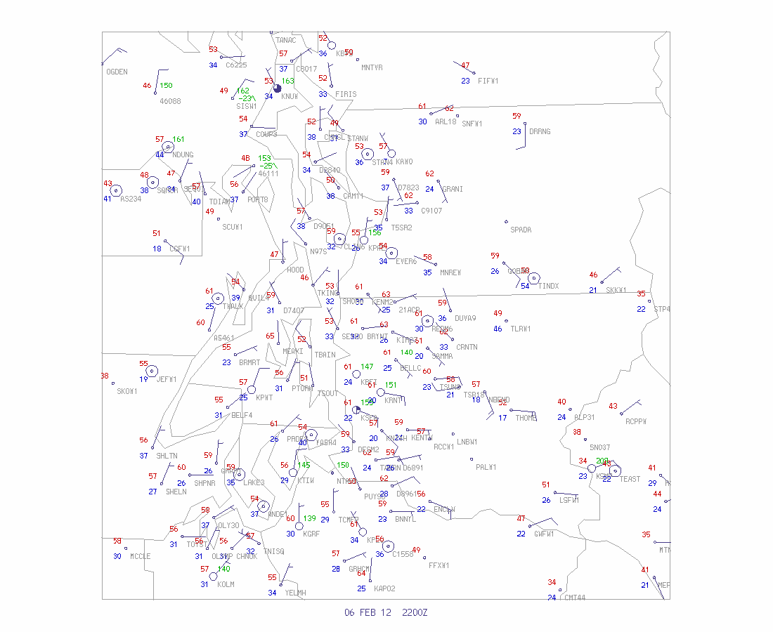
This morning at 6 AM, before the sun rose, here were the weather conditions at the surface:

During the day, with solar heating destroying the inversion, conditions were more uniform. Here are the conditions at 2 PM: temperatures ranging from the mid 50s to LOWER 60s. Yes, these temperatures are more typical of April than February. You notice a lot more easterlies on this map?...that is because they were able to mix down to surface with the solar heating during the day.
During the summer, the sun is strong enough to destroy any inversions quickly. Midwinter, particularly December and early January, the inversions often win. Tuesday will be another fine day. But Wednesday will see some degradation--chance of light showers and cooler temps.


Definitely saw this on my commute from Snoqualmie Ridge to Redmond via SR-202. Here at home it was 50 at 7:30a, and very windy. 5 miles away on the Redmond side of Fall City it was 29 and dead calm.
ReplyDeleteWinds are howling tonight too - house has been shaken by a few gusts.
Thanks for the explanation. Was 18 this AM in Eastern WA (although afternoon crisp sunny 40's). Drive back to Seattle was stunningly beautiful across Columbia river and through mountains. Into the battle you describe. Weird winds on west side of Cascades from top of Pass to North Bend.
ReplyDeleteThe winds are blowing here in the foothills 3 miles N of Monroe! And it's been very warm. Love this break from the cold. Finally melting the last piles of snow from a few weeks ago. Thanks as always for the informative blog, Cliff!
ReplyDeleteVERY windy in Enumclaw, power has been off and on all night. Love the east winds!
ReplyDeleteWe're seeing these big temp swings in Tacoma this morning, with very little wind. It's 45 at our house in north Tacoma, I note 49 at the Tacoma Narrows airport, but 25 over at JBLM.
ReplyDeleteLike Santa Anna winds!
ReplyDeleteWatching the planes coming in to SEA last night from Beacon Hill you could definitely see how strong the easterlies were just a few thousand feet up. They were all flying with the body of the jet at a pronounced angle to the direction of travel. Yet at the ground it was mostly calm. Thanks for the explanation!
ReplyDeleteFlying in a Cessna 172 last night (2/6) over the north end of Seatac (from west to east) we had an indicated airspeed of 100-105 knots (115-121 MPH) but a groundspeed on the GPS of 60-65 knots (70-75 MPH). The Seatac Tower controller noticed our slow progress and asked our indicated airspeed - laughing at the response. Several landing jets reported significant wind changes of 5-15 knots as they passed through 900 feet asl. Those easterlys were really moving last night.
ReplyDeleteRode my bike to work from Squak to Bothell. 53f at my house and windy. Tailwind along east lake Sammamish and sweaty warm. Took my hat off entering Marymoor and the temp plummeted with frost on ground. Headwind also from here on. It was like stepping into a walk in freezer the difference was so sudden. Hat went back on!
ReplyDeleteYou always state downslope compressed air is much drier, but it wasn't mentioned in this post. No problem, but thats what i've been noticing these last few days.
ReplyDeleteWhich consequently is why it has got so cold at night if wind protected. Low dew point temperatures.
Can you comment on the unusually cold weather in Europe where they are having temperatures of -30F?
ReplyDelete