Is winter over?
In one sense, the answer is yes. Meteorological winter ends roughly the third week of February in western Washington. After that it is difficult to get the really big winter weather events: record floods, historic windstorm, big lowland snow storms.
We are now close enough to that period to know that it is unlikely that we will get a major event before the typical transition to spring. The persistent ridging that has been the hallmark of this winter is not going anywhere. To illustrate, here is the forecast upper level (500 hPa) weather chart for next Tuesday at 4 PM. Big ridge. Again.

But anyone who has forecast around here for a while, knows that there have been many warm/dry early winters that have been followed by wet/cool late winters/early springs.
Last year was a good example, with the atmospheric tap turning on the second week of February, resulting in a huge increase in snowpack and a near-record wet period---which may have contributed to the Oso landslide.
And never forget that the Cascade snowpack typically increases until roughly April 1st, as illustrated by the following example at Stevens Pass. The green line is the average snowpack there and the black line is this year. As shown by the red line, it has been worse.

But let me be clear, I am not optimistic for the remainder of this year and virtually every tool at my disposal suggests that the preternatural warmth will continue.
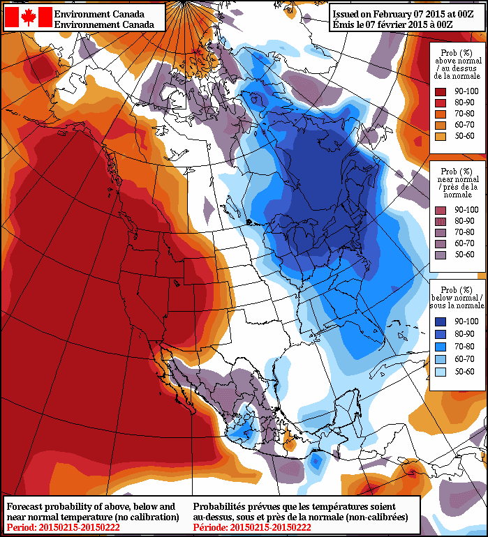
Every long-range forecasting model suggests warmth will continue, as will the associated ridging. To illustrate, here is the forecast temperatures from the North American Ensemble Forecasting System (NAEFS), that combines the long-range model output from the U.S. and Canadian Centers for Feb 15-22nd showing the percentage chance of being above or below normal for that period. They are 90-100% sure it will be warmer than normal. They don't get any more certain than that.
And lets take a look at the National Weather Service's Climate Forecast System predictions for the next three months for surface air temperature (actually the difference from normal--the anomalies). Amazing. A HUGE WARM ANOMALY over our region. And these anomalies are very statistically significant. My confidence in this forecast is strengthened by the fact that is probably the result of a relatively slowly changing atmospheric circulation variation that is connected with slowly varying sea surface temperatures in the Pacific (more on that in a future blog). Note that eastern U.S. is colder than normal. This is not some kind of global warming where everyone experiences higher temperatures.

When the ridge is over us, we are dry. But if it slips to our east a bit, we move into warm, wet southwesterly flow. The example below for Friday night at 7 PM (weather map at 300 hPa) illustrates this situation. The colors are wind speed and the winds are parallel to the height lines.

The Pacific Northwest Weather Workshop
Interested in attending the big local weather workshop of the region? The Pacific Northwest Weather Workshop will be held in Seattle at the NOAA facility on February 27-28th. Everyone is invited and the majority of talks are accessible to laypeople. To attend you have to register or they won't let you in the gate. There will be a major session on the Oso landslide. There is a registration fee that covers refreshments and food, and special student pricing. If interested, check out this website.
Climate Change and the Pacific Northwest
I will be giving a provocative talk on this subject on March 11th at 7:30 PM Kane Hall on the UW campus in Seattle. Sponsored by local public radio station KPLU, tickets for this event can be secured at this web site.


Yep, my lawn is starting to look like hay, too wet to mow, might have to bring in some sheep!
ReplyDeleteI live in eastern Oregon and these warm winters are starting to drive me crazy. I am looking to move somewhere with more snow, but would be sad to leave Oregon.
ReplyDeleteI am considering moving to Montana or Vermont, but would rather move to the Blue Mountains in Oregon at about the 5000 foot level.
With this warming trend seeming to be an ongoing problem, will there be consistent snow in the Blue Mountains in the future, or should I just move back East? Their snow seems more consistent.
I know no one knows for sure, but where would be the best bet for future snow? I appreciate any help you can give me!
If the snow is what you want, move to the Rockies.
ReplyDeletePatricia Lovejoy said...
ReplyDelete"I live in eastern Oregon"
Patricia, Eastern Oregon is one of the most diverse beautiful places on the planet. The East Coast can't compare. Weather is cyclical and winter will return! Anywhere in Eastern Oregon above 5,000ft should get a lot of snow. The Wallowa's are my personal fav's.
The persistently high SST's (sea surface temperatures) have happened before. I don't have access to data at this time, but from what I've heard from other meteorologists is this happened back in '57, '58, and '76,77 and '78. This warm pool in the North Pacific seems to come about with either a PDO change like in '76. The PDO changed again to negative about five years ago and when it did, this warm pool showed up in the north central Pacific ocean and has been moving in our general direction. It is now on our coastline. When it dissipates, winter will return with a vengeance (and maybe with a La Nina to boot).
ReplyDeleteI know there is no conclusive evidence that the non-wintery winter weather we've been experiencing is the result of human caused climate change. But is there conclusive evidence that it is not?
ReplyDeleteI've been living in Seattle for over 21 years and it's been my observation that it's not uncommon to have a "snow event" in March.
ReplyDeleteI live just SE of Chehalis, up about 600 feet. I started hearing frogs, two weeks ago. Had a bee swarm in my potting shed, week before last. A wasp paddling around in a water bucket. The Wooly Bear caterpillars have not disappeared at all, this winter. Omens, signs, miracles and wonders. :-)
ReplyDeleteLast year the hummingbirds showed up just before the 15th of March. I thought I'd hang them on the first, this year. Maybe even earlier. Lew
" This is not some kind of global warming where everyone experiences higher temperatures."... That's kind of an interesting quote, Cliff. I don't think we've every yet had a situation where everyone experiences higher temperatures simultaneously yet. There is always some part of the globe that is experiencing below normal temperatures. And yet, 2014 was the warmest temperature ever measured since modern temperature taking began. And 2014 was also one of the warmest ever in Washington's history. Certainly, some significant component of our very very warm winter is resulting from climate change.
ReplyDeleteBill,
ReplyDeleteNo...I don't think that global warming has anything to do with our warm winter...something I will explain in a future blog..cliff
Bill,
ReplyDeleteNo...I don't think that global warming has anything to do with our warm winter...something I will explain in a future blog..cliff
This is our second winter with Anna's hummingbirds that never left. We're up north of Bellingham, close to the Cascade foothills and in the Fraser outflow path. The pond frogs started their night time courting a couple weeks ago, and I cut my first daffodil last night.
ReplyDeleteI do recall a few late snow flurries though, once on April 1st even. Who can say...
Anyone know where I can see what the freezing level in the Cascades has been this winter? If it's consistently high, especially during winter, I'm concerned we'll get glacial melt - compounded by low snowfall, high rainfall. That's a potential for a large volume of water and mud flowing downhill. I wonder if we can expect to see more large events like the Oso slide.
ReplyDeleteCorrect me if I'm wrong Cliff, but last year at this time the pacific warm blob's influence was considered small but building, currently - large but deteriorating. Next winter should hopefully be right around normal? Re: Lovejoy, don't go anywhere!
ReplyDeleteCan I pose a new topic question?
ReplyDeleteWhat can you say about the dirty rain that fell in eastern Washington on Friday? Some say it came from a Russian volcano, others from a dust storm in Nevada. Just curious how the winds were able to carry the particulates that far.
Cliff...
ReplyDeleteThe oceans and atmosphere have been steadliy warming for decades. That extra heat is stored in both our atmosphere and our oceans. You can explain the our warm winter as resulting from a particular arrangement of ocean currents, a warm "blob" of offshore water, atmospheric patterns and that explaination can make perfect sense. But that extra heat has diffused throughout the system at this point and I think its impossible to say definitively that some component of our current temperature at any given poing does not have some amount of that extra heat. That just does not make sense to me from a simple understanding of heat mixing thoughout our systems. I await your explaination with interest.
Bill,
ReplyDeleteMy next blog will attempt to explain this issue. The earth is not warming steadily and different parts of the globe warm at a different rate. A key issue is whether this event would have happened without global warming...the answer I believe is yes. Of course, there is a minor contribution of general warming, but that is dwarfed in this case by natural variability...cliff
The frogs started here in Stanwood too. Bumble bees are out too.
ReplyDeleteIt's a little earlier than usual.
A long time ago they would have called this a blessing.
Cliff,
ReplyDeleteSnowstorm wallops Boston with 20 more inches; breaking records. Any correlations to our lack of snow?
What year is represented by the red line?
ReplyDeleteHi Cliff...
ReplyDeleteWhen I said in an earlier comment that temperatures are rising steadily I meant in a broad sense. Globally, the 00's were warmer than the 90's, which were warmer than the 80's, which were warmer than the 70's. There is climatic noise in the system, patterns that have to do with climate, there is uneven heating of the globe. But over time the excess heat trapped in the system has exchanged to a degree from area to area and from air to water and to land. This excess heat is now, to some degree, part of most every global air temperature.
Last year projections show a strong El Niño, then weakening. I Am wondering if that was more of a timeline since we had a relative wet December, and virtually nothing since. Also, what influence does a big monsoon season have(like last summer)?
ReplyDeleteI am in SoCal.