But that is over now.
We are moving back to a new configuration the atmosphere seems to like recently: high pressure over the central North Pacific and troughing (low pressure) over our region. As a result, expect cooler than normal and wetter than normal conditions for several days.
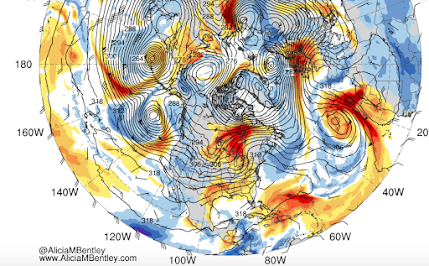
The upper level (500hPa pressure level) for Tuesday at 5 PM illustrates what we will deal with the next several days. BIG RIDGE south of the Aleutians and a trough over the Northwest. This is not a warm/dry pattern for us.

The precipitation forecast for the next 72h (through Wed. at 5 PM) shows rain stretching from western BC to northern California,


The extended forecast from the North American ensemble (many forecasts) system (NAEFS) for Seattle shows temperatures staying cool (20C is 68F) with lots of clouds through the end of the month.

The sun is rapidly weakening now, the nights are getting longer, and the atmosphere is increasingly showing fall-like circulations. No more 90s in the west, and I would not bet on seeing an 80F anytime soon. This is all very good news for the fire community. Cool, wet weather without lightning. Fire season is rapidly ending.
The city of Seattle can probably quit their ad campaign for water conservation. Our plants will be watered naturally and our reservoirs will start to fill. The level of Chester Morse Lake has greatly stabilized with the recent rains and conservation efforts. The rain this week will result in the levels rising.

The surface temperatures continue to cool offshore, which will influence our temperatures as well. And snow will fall over the high country of the North Cascades and southern BC mountains.
Enjoy the return to normality
Finally, it was really raining in Seattle this AM. Few tenths of inch in places. But it was sunny in Bellingham and Olympia and most every place else. Why? A localized Puget Sound Convergence Zone, with air passing around the Olympics and converging over central Puget Sound. Here is the satellite image around 1145 AM.
So if you are in Seattle and want sun, head out of town. Clouds should be reduced by mid-afternoon,


I'm happy that it has cooled in the PNW after the warmest summer (June, July, August)of record.
ReplyDeleteThe PNW was not alone with record summer temperatures:
From meteorologist Jeff Masters:
"This July 2015 was the warmest July on record for Spain, Italy, Switzerland and Austria," said Weather Underground Director of Meteorology, Dr. Jeff Masters.
More from Jeff Masters:
All-time record heat in the Caribbean
Record heat scorched the Caribbean again on Saturday. According to weather records researcher Maximiliano Herrera, an all-time heat record was set on the island of Anguilla in the Lesser Antilles: 33.8°C (92.8°F), besting the record of 33.7°C set just four days previously. The Cuban capital of La Habana (Havana) also recorded its hottest temperature on record and the hottest temperature ever measured in September in Cuba, with 38.2°C (100.8°F) at the Casablanca Observatory.
From meteorologist Chris Burt:
Phoenix reached 117° on August 14th, its hottest August day on record (amidst its warmest summer on record) and saw three consecutive days with minimums of 93° (August 14-16), also a record for such.
San Francisco (downtown site) saw 15 daily record high minimums during this past August
Caribou, Maine experienced its warmest August on record with a 68.2° average temperature (old record 68.0° in August 2012).
Hawaii
August was the warmest month on record (any month) for Hilo with a 79.7° average temperature, surpassing the previous month of July (79.4°) as warmest month which in turn smashed by a large margin (for a tropical location) the previous such of 78.5° set in August 1994. Furthermore, 12 of the 31 days of July set or tied a daily record high and in August, an amazing 15 out of 31 days achieved record daily high status. On August 22nd, the daily low temperature of 77° was the warmest minimum ever observed at the site (76° was the previous record set on three former occasions and once again on August 23rd this month). This has also been the warmest climatological summer on record for Hilo with a June-August average temperature of 78.6°. The previous warmest summer was that of 1986 with a 77.6° average.
JFK Airport in New York City also observed its warmest August on record with a 78.5° average, although records go back to only 1948 at the site. New York City’s official weather site in Central Park has now logged 60 consecutive days with maximum temperatures attaining 80°+ (since July 11th) and still counting as of September 7th. This streak has smashed the previous record for such of 41 days observed in 2011. This record streak looks likely to extend until mid-September given current forecasts.
Europe again slathered with all-time record heat; Berlin has hottest day on record
Just one month after setting its all-time national heat record, Germany tied that mark on Friday at the same location, as yet another multiday heat wave swept across much of Europe. The German meteorological agency (Deutscher Wetterdienst) confirms that the town of Kitzingen reached 40.3°C (104.5°F) on Friday, the same national record it reached on July 5. According to Michael Theusner (Klimahaus), more than 100 towns and cities in Germany either tied or broke their all-time record highs on Friday. Berlin's Kaniswall station hit 38.9°C (102.0°F)--the hottest temperature ever observed in the Berlin area, beating the old record of 38.6°C (101.5°F).
Nice that we are getting back to more normal weather now that this anomalous summer has been safely filed away in the record books. At least we now understand the Blob and what it can do to the PNW. It'll be very interesting to see if we get one of those in future years, and what further research says about its likely cause and forecast predictability.
ReplyDeleteMy recollection is that when Fall begins this way (and this early), we often get an Indian summer in October. Not sure what the science and statistics (not to mention the squirrels and caterpillars) say about that, but in any case, those can be special.
So I'm ready to enjoy a month of cool and wet, and will remain hopeful of a brief reminder of summer in October before we get slammed with November storms. I root-watered my new trees all summer to keep them alive, so its nice to be able to turn off the taps until next year.
It's the new old normal. Hopefully no more sprinkler use needed in 2015. But Indian summer is nice too.
ReplyDeleteSay it ain't so... wow, three whole months and people are burned out on summer!?
ReplyDeleteDo you remember how you feel in February?
I was burned out on summer in early June. I feel fantastic in February.
ReplyDeleteFollowing the NWS forecasts the last few days has been fascinating. The models have bounced all over the place, and the NWS forecast discussions bounce right along with them. I think within 24 hours, the discussion went from "it's all going through Oregon, maybe a bit or rain" to "watching carefully, could be bigger than the August windstorm" and then back to something in between. I assume this is because the North Pacific is, in relative terms, a data desert, there's just less to feed into the models to initialize them properly. and the forecasters don't have much else to work with?
5 day forecasts in the Southeast were generally very accurate. In the Northwest, however, we learned never to make assumptions - even based on a next-day or same-day forecast. That paid off nicely two weekends ago, when we had raingear accessible and kept right on with our outdoor plans the day that "sunny" NWS forecast proved to be a spectacular bust.
Can't wait, bring on the rain and storms. Love it!
ReplyDeleteThis is proof that global warming is not happening!!!! Surely, if a hot, dry summer was proof that global warming is for real, a normal autumn is then proof that it's not! RIGHT???
ReplyDelete;-)
"Say it ain't so... wow, three whole months and people are burned out on summer!?
ReplyDeleteDo you remember how you feel in February?"
For those of us with summer depression variant of SAD, we feel incredibly happy until about March and then start dreading the summer that's coming.
I honestly find it perplexing that sun, green leaves and flowers could cause someone to be depressed while cold, dead twiggy trees are a reason to feel incredibly happy.
ReplyDeleteBut I'll concede that it is possible it exists. I assumed it had more to do with feeling miserable in uncomfortable heat, but perhaps just inherent brightness just feels oppressing somehow.
Anyway, that is besides the point because the northwest really isn't all that depressing in the winter either, there are plenty of sunny days usually. With 2100 sunshine hours we get 800 more hours than gloomy areas of Europe from the British isles to Russia. Even Rio de Janeiro doesn't average that many more sunshine hours than seattle. The northwest is more screws toward a lot of sun in the summer, but not so much that 9 months are miserably dark. They aren't, and it just isn't true. Seattle gets a respectable amount of sun for a city by most cities standards.
This summer, especially, most certainly did NOT bring the flowery greenery to which you refer above.
DeleteThe persistent eyesore (lasting months upon end) of unavoidable burnt-out dead brown grass is highly depressing. In stark contrast to your statements, it is perplexing that anyone would revel in such ubiquitous lifeless surroundings.
It's pretty clear that people are long tired of hideously shriveled plants, dead grass, and leaves dropping months prematurely. Any improvement in the natural vegetation (with a hopeful full return to green surroundings) can only be a good thing.
If this year's dry spell was too short for you, its persistent sun and aridity at the expense of all vegetation, then Phoenix would be a more suitable climate. Seattle is not where one would come to look for heat and dryness.
Brendan... I'm not a summer fan either, but it isn't just the heat. I have A/C for that. Or the love of more barren winter plants (although I'm a evergreen kind of guy, so its not too bad). Or the mold and moss (hey, they're green).
ReplyDeleteIt's the brightness of the summer sun. I enjoy summer gardening, and my plants sure like the sun, but I can't tolerate it. Doc says my skin has seen all the sun it should in this lifetime. And when its hot, covering up to go outdoors is miserable. This was one of reasons I moved to the PNW ten years ago.
Now I have much more fun gardening indoors in my heated greenhouse in the winter. Out here on a hill above Sequim, we get 1.5x the sun of Seattle on a yearly basis, but about the same in summer like this, so its plenty bright to grow most things in winter. Even tomatoes ripen all year (although not as fast in February).
The kind of weather we've had this last week has been vastly improved. Now if we just get some light to moderate rain a couple of days a week it'll be perfect. I'm no fan of February though, because that's when the muckies finally get me. We have a clayish soil, so somewhere between late December and February (depending on the year) it absorbs enough water that my four-wheel drive Kubota tractor can't even make it up and down my rather steepish property. Tractor got stuck down the hill behind the house for three months once. The shorter the annual Muckies the better.
But I'll take that over all that oppressive sun.
Once again we're tempted here in north Whatcom County by the promise of rain, only to be left high & dry. Not that I don't enjoy a good late season sunny & mild spell, but I gardened based on the forecast. Rain was predicted for Monday. Then it pushed back to Tuesday. Then Wednesday...and Thursday...and at this point Saturday is our earliest hope. Pretty surprising & annoying that forecasts can be this consistently wrong. What gives?
ReplyDelete"If this year's dry spell was too short for you, its persistent sun and aridity at the expense of all vegetation, then Phoenix would be a more suitable climate. Seattle is not where one would come to look for heat and dryness."
ReplyDeletePhoenix averages more rainfall than Seattle in July. Seattle, long term avg precip, July: .79 inches; Phoenix, long term avg precip, July: 1.05 inches. Source: NWS
Dry and often beautiful summers are our climate and have been since records were kept. Of the 37+" of rain we get per year, about 3 (3.39 to be exact) fall, on avg, in the combined months of June, July, and August. No argument here that this summer was dryer than normal, but count me as one of those who thoroughly enjoyed every blue sky day. We'll pay for it later.
But I will take Phoenix in January :)