One of the most overused terms used by the media is "atmospheric river". Yes, even more hyped than "bomb cyclone." But this week there will be an atmospheric river worth noting...and I will discuss below.
Atmospheric River Overuse
Although the term, atmospheric river, was first used in the late 1990s, the phenomenon was well-known for decades before that: a plume of warm, moist air leading cold fronts associated with midlatitude cyclones.
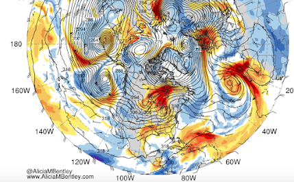
Virtually every midlatitude cyclone/low center has such a plume of moist air. To see how omni-present atmospheric rivers are, below is map from today of the plumes of water vapor (red and orange colors) and heights at 700 hPa pressure (think of this as pressure at 10,000 ft). LOTS of atmospheric rivers, with most associated with low centers and their associated fronts.
But not all atmospheric rivers are equal in magnitude.
This week some particularly strong ones will aim at northern California and southern Oregon, releasing intense precipitation as the moisture-laden area is forced to rise by the regional terrain.
One of the best measures of atmospheric river strength is integrated water vapor transport (IVT), which is calculated by determine how much water vapor is being transported by the atmospheric river over a period of time (essentially wind speed times water vapor content of the air).
Here is a plot of IVT on Wednesday evening. WOW...that is quite an atmopsheric river!
The result or this atmospheric river and some weaken cousins this week, will be massive rainfall on the West Coast.
Snowpack is in good shape for the entire Wast Coast. (see below).


I like the more colorful term "Pineapple Express". But I take it that not all atmospheric rivers qualify as Pineapple Expresses, if they aren't warm enough. I'd define the latter as having a temperature at sea level of at least 55 degrees, or even better, 60. Is there an official definition?
ReplyDeleteI had the same thought, but my take is that "Pineapple Express" wasn't sufficiently clinically dramatic; therefore, "Atmospheric River".
DeleteWith the Pineapple Express, the plume of moisture can be seen stretching all the way down to the tropics and as far west as Hawaii. I'd say a few days of the Seattle area reaching the upper 50'S or lower 60's qualify. Oddly enough, the Pineapple Express is responsible for some of the best winter weather the Seattle area can get, but only if there's a long enough break in the moisture while the mild air remains in place.
DeleteWhy is there a need to give everything a cute marketing name? Where does that need come from? Makes me cringe.
DeleteBTW, there is very little left of the pineapple industry in Hawaii. Like everything else, it's a job that was given over to third world countries a long time ago.
"Remember all the talk of permanent drought in CA during the global warming.
ReplyDeleteWell, such predictions have not worked out well."
Amen, Cliff!
I thought the whole thing about California drought was more that the underground water basins are low and not refilling, because even when it rains hard the top soil is dry and packed so the water flows off. Then the farming drains these basins more. I wonder if there's any charts of the underground water basins?
DeleteGreat post, very instructive. Many thanks. Here's to reality!
ReplyDeleteReality! Prosit!
DeleteToo bad the SW won't be getting the rains they really need it based on the latest drought monitor.
ReplyDeleteWasn't it called a "Pineapple Express" before? I guess that had to much of a positive connotation and so didn't seem as dramatic as "Atmospheric River"?
ReplyDeletePineapple express storms are warmer, typically, mid 50's to mid 60's and come out of the southern Pacific, but no further than Hawaii, often have high winds and/or thunderstorms associated with them. Have not had one in a long time.
DeleteNorthern and central do indeed look good, but what about southern Cal? A lot of soCal's water comes from the Colorado River. With no sign of rain in southern Calif, central and southern Colorado and most of Arizona don't they fall into the drought category?
ReplyDeleteDo you know who else loves to over-hype these terms? Climate change alarmists that somehow think that an atmospheric river or a bomb cyclone is a new phenomenon and is tied directly to global warming! Meanwhile here we call it storm season. It would be much more alarming if we DIDNT get these storms during our wet season and of course then they'd be screaming drought.
ReplyDeleteThis may be the winter for... https://www.scientificamerican.com/article/atmospheric-rivers-california-megaflood-lessons-from-forgotten-catastrophe/
ReplyDeleteMaybe beginning of the next California megaflood? https://www.nytimes.com/interactive/2022/08/12/climate/california-rain-storm.html
ReplyDeleteI know this off topic but a curiosity question...if there any cold/snow looming in the future...
ReplyDeleteCold commeth:
ReplyDeletehttps://www.cpc.ncep.noaa.gov/products/predictions/long_range/seasonal.php?lead=1
Most of Canada is below freezing -- build a wall, soon!
Seems that future generations would benefit if we build more reservoirs throughout the west. Cliff has taught us that, over time, natural variability promises us heavy rain sooner or later: it makes sense to capture it wherever we can.
ReplyDeleteThis comment has been removed by the author.
ReplyDeleteNot sure why you say the term "atmospheric river" is overused given that you go on to say "To see how omni-present atmospheric rivers are........LOTS of atmospheric rivers, with most associated with low centers and their associated fronts."
ReplyDeleteIf their scientific name is atmospheric river, and if they are omni-present, what are the weathermen supposed to say? Something more scientific like "really rainy" or "enough rain to float a frog"? Your complaint makes you sound like somebody from the anti-science crowd. Or did you mean to say "they" use the term incorrectly?