December 30, 2019

Strong Winds and Lots of Precipitation Ahead

It is time to find an umbrella, but it needs to be a sturdy one, since a significant blow is ahead of us.

Looking out into the Pacific, an impressive line up of moisture is heading our way, while a small cyclone is threatening Baja California.


Tomorrow, a moderate-strength cyclone (roughly 990 hPa central pressure) will make landfall on the northern tip of Vancouver Island (see sea level pressure map for 1 PM Tuesday).  With relatively high pressure to the south, a very large pressure gradient will occur over western WA and the coastal waters.  The result?  Strong winds.


Let's take a look at the predicted winds, using a graphic from the city of Seattle WINDWATCH site, which shows predicted wind gusts over Seattle.  Major winds ramp up tomorrow morning, with wind gusts hitting around 40 mph during the afternoon and early evening.  That is generally enough to break some branches and produce some power outages.   Not a record-breaking storm but the most powerful winds yet this winter.  The fact that the multiple forecasts shown in the plot are all going for a significant event provides some confidence that we will have a good blow.


Winds will start revving up even earlier over NW Washington, where southeasterly winds could hit 40-60 mph overnight.

And then there is the bountiful precipitation.  For the 24-h totals  ending 4 AM tomorrow, moderate amounts over northwest WA as the storm approaches.


But the next 24-h will be sodden, with 2-5 inches on the western side of the regional mountains, but substantial rain shadowing over the western lowlands.


Now, you want to be impressed?  Here is the accumulated rainfall over the next 7 days.  Some locations approaching 10 inches.


And yes, snow.  Initially, the freezing level will be high, but cooler air will move in by Thursday.  The snowfall totals are measured in feet over the next week.  Good for snowpack and skiing.


December 28, 2019

The Deadliest Weather Phenomenon in the Northwest

What is the deadliest weather phenomenon in the Pacific Northwest?

A major Pacific cyclone, with gale to storm force winds?

Heavy rain and flooding associated with intense atmospheric rivers?

Thunderstorms or lightning?

I don't think so.  From my experience, the biggest threat is from a weather feature that most folks would think benign:  FOG.  And particularly its freezing version.


Consider some the headlines in the news this fall.

Two weeks ago there was a 15-car pile up in freezing fog on the Umatilla Bridge on the WA/OR border.

Plus,  multiple accidents in Richland at the I-82/182 interchange the same day.


Two days before, 4 cars were in accidents  in fog on the Palouse Highway.

I could give you dozens of other examples.  Early in my career I did some forensic meteorology, providing information for legal cases.   The number one issue for such cases was freezing fog resulting in serious accidents.  And some accidents occur without freezing fog--just folks driving to close and fast.  A pack of cars enters a fog bank and  the first car slows down, followed by chain collisions of cars behind.

Fog is particularly a problem during cold weather.  Frost can make a roadway slippery, but generally doesn't create a think layer of ice on the roadway.   But fog is a different story.  Around here, fog is generally made of liquid droplets, even when temperatures are below freezing.  The water is supercooled and when the fog goes over a roadway that is chilled below freezing, the fog droplets can freeze on contact, producing a significant ice layer.


So anytime temperatures shown by your car thermometer or the local weather reports get below 35F, and fog is around, you should slow down and maintain a generous following distance with the car in front of you.  Why 35F?  Because in winter road temperatures at night are often cooler than in the atmosphere immediately above.  Freezing fog obviously has a double threat---visibility can be very poor, so when one car hits slippery conditions and slows down, other cars, driving too close and fast, slams into it.

Eastern Washington is particularly vulnerable to freezing fog this time of the year, as cold, foggy air tends to pool into the Columbia River Basin.  The Willamette Valley is also a problem location, with the south Sound and SW Washington often have issues (see satellite picture below).  So during foggy conditions, conservative driving is good idea.


December 26, 2019

A Dry Year With a Twist and Few Major Fires

2019 was generally a drier than normal year.   But there were few fires during the summer and little smoke in western Washington and Oregon.  How can that be?  And agriculture was generally fine.

So let's talk about this year's precipitation, which we can do since there is only a few days left of the year.

There will be some rain the next few days, but nothing serious over Washington (see the prediction for accumulated precipitation for the rest of the month).  Around a half-inch over the lowlands, a few inches in the mountains.     In fact, with general westerly flow, Puget Sound will be substantially rainshadowed by the Olympics. Much more over coastal British Columbia.


But let's look backwards to the beginning of the year.  As shown by the map below, California, Nevada, and southeast Oregon have been very wet, but western WA has been quite dry, much of it with 70-90% of normal.  Not the end of the world, but less than normal.  The moisture over California played a big role in keeping the fires down and ensuring plenty of water there.


However, the annual precipitation total does not tell the whole story.  Below is a plot of the accumulated observed (purple) and normal (cyan)  precipitation for this year at SeaTac. 

The year started near normal, but we fell behind in spring, but slowly caught up during summer...that will be important. A wet September almost brought SeaTac to normal.  Then we had a very dry October/November and Seattle fell to 10-12 inches behind.  But fortunately, the big rain of last week got us to a few inches below normal.   An meteorological roller coaster ride!
In contrast, Quillayute, on the WA coast, was not only drier than normal, but did not get the big atmospheric river rain experienced by Puget Sound and SW Washington.  Shows how narrow the atmospheric river was.   They are a good ten inches below normal right now.   But really no serious implications of this....they still received 70 plus inches.
Yakima, on the eastern side of the Cascades, ended up wetter than normal, thanks to a very, very wet February/March
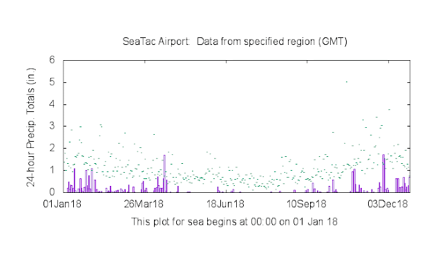
So why few fires this summer, while 2018 had things ablaze.  Particularly since the overall rainfall here in Puget Sound was nearly the same during both years.  One explanation: precipitation were very different during the summer between the two years.  To show this, here are plots of the daily precipitation for 2019 and 2018.   For 2019, we had frequent light amounts throughout the summer.  Keep things cool and relatively moist.

In contrast, 2018 had long summer period without rain.  THAT made a huge difference. The smoky year or 2017?  A year that had much more precipitation.  2017 had a very extended dry period during the summer (see below)
So the natural question you might ask, are our summers getting drier or were the last few years just random excursions?  Below is a plot of July/August rainfall totals over Puget Sound for 1900-2019--a good measure of what is coming into the region (this is the NOAA climate division precipitation for WA Division 3).

2017 and 2018 had very low summer totals, and  you can see the rebound in 2019.  In fact, 2017 was the lowest since 1930!  Is there a long-term trend.  Really hard to say.  Not much over the entire period, but a drying trend over the past 40 years.

What would we expect under global warming? 

Well, I am in a position to give you some new information on this.  We have run high-resolution regional climate models for 130 years (1970 to 2100. And we did this for an ensemble of many (12) global climate models.  The results, shown below for Seattle for a VERY aggressive increase in CO2 (we go crazy with coal!), indicates a very, very slow downward trend of summer precipitation.

My conclusion:  low precipitation for 2017/2018 was probably just random chance--good news for our future summers the next few decades.

December 24, 2019

Seattle's Green Heroes

There is so much negative news these days that some might despair about human nature and our ability to work together to sustain our natural environment.

But there are a number of examples, hugely positive ones, of concerned citizens working together to improve the outdoor environment of Seattle and our region.     This blog will talk about one group of Seattle residents that have taken on the huge task of regenerating the parks and outdoor natural spaces of the city.  And I will even tell you about a mysterious fairyland you can visit.


All around the city, folks of all ages have joined the Green Seattle Partnership, with the goal of improving our green spaces.  They plant native trees and bushes, clear invasive species, get rid of debris and junk, and much more.  Often  really hard work.  Dirty work frequently.  But a big contribution to our community, and I know very satisfying to those involved.


An example of a very active area of such effort is along the heavily traveled Burke Gilman Trail, which is under the aegis of the Seattle Park's department.  Nearly every day there are volunteers working to get rid of the invasive blackberry bushes and other invaders (a very difficult task), replacing them with native plants supplied by the City of Seattle.  Below is an example of a major work party on Sunday on the trail near NE 90th street.  They had hundreds of plants to put in the ground. And the city of Seattle also supplies mountains of bark mulch protect the young plants from summer drying conditions.
.


Even today, Christmas Eve, two stalwarts (Dean and Reza) were hard at work.


The most committed become highly trained forest stewards, who can supervise others and plan improvements.  They also bring in students and classes to help with the work, where they learn about plants, soil, and fostering a healthy environment.  This is the true Green New Deal.  Sometimes the stewards have to contend with difficult situations that have nothing to do with plants-- they must deal with some of the homeless folks that now make their homes within our parks.

 The City to its great credit, gives these stewards substantial autonomy and independence.     Some of the things found during the renovations are quite interesting, including ancient beer bottles and reminders of the past railroad days.  As an aside, someone should write a book on the Burke Gilman Trail, which is perhaps one of the most successful rail to trail project in the country.


But now let me tell you about something magical.   One forest steward (Heather, a retired judge) has literally built an enchanted forest along the Burke Gilman trail around NE 90th St (just north of the little stream).  A series of trails, wooden bridges and entwined fences, and some wood Adirondack chairs for sitting.  But the most amazing thing is found where a huge tree had fallen.  A door is found entering the tree, with little gnomes all around (see below).


Open the door and you enter a different world.  I won't tell you the details.


But let's say, there are plenty of the little folks you see below.


You should see the faces of 3 or 4 year olds when they enter this fantasy domain, and folks of any age can appreciate the immense creativity and work by Heather that created this several acres wonderland.  Kudos to the City for allowing it.

So at this special  time of the year, with both Christmas and Chanukah overlapping, it is nice to pause to appreciate the altruism and environment commitment of some of our neighbors.  It gives one hope that in the end, our better natures can prevail.

December 22, 2019

The "Dark Storm" Continue into Saturday But is Now Abating

The infernal darkness on Friday was extraordinary, even by Seattle standards, and to a lesser degree continued into Saturday.  But sunglass owners can rejoice:  more light in on the way.

Let me give you the numbers.

On Friday, the total solar radiation measured at the University of Washington was .37 mega (million) joules (a unit of energy), breaking the previous record of .39.    As I explained in my previous blog, this record was the result of the time of the year (December 20th is nearly at the winter solstice) and a deep, deep cloud cover from a super-moist atmospheric river.

I have termed a name for such a severe event:  a dark storm.

It was an event reminiscent of something that would have been familiar to Pharaoh: the next to last plague when he refused to allow the Jews to leave Egypt.

The Pharaoh Learned About Terrible Darkness

Saturday was only a bit better, with a total of .76 megajoules, the third darkest day of 2019.  Twice as much solar radiation as Friday....almost enough to think about finding your sunglasses. 

Why the improvement?   We still had the atmospheric river clouds over us, but thickness of the clouds and precipitation were less than the record-breaking conditions on Friday (see satellite image from Saturday around noon)


Solar radiation is already much higher today than either Friday or Saturday (see plot from the roof below through 11 AM)

But now let me show you something never seen before on this blog:  forecasts of solar radiation reaching the ground!  First, the short-term forecast for Friday at noon.  Black color over much of western Washington.  You know what that means. It isn't good.


Today? No black.  A reassuring blue color for much of Washington.


Monday is more of a mixed bag.  There will be clouds banking up on the western side of the Cascades, bringing darker conditions there.  But some locations in western WA will be brighter and southern Oregon will be quite luminous.


Is there a trend in solar radiation reaching the surface?  We really don't have decent long records, but WSU's AgWeather network has some sites going back 20 years.  From what I can see, there is little evidence of significant long-term trend (see annual observations at Mt. Vernon,WA below--perhaps a slight increase at that station.)  As part of my climate research simulations, solar radiation at the surface is projected....I will take a look at that soon.


December 20, 2019

The Darkest Day in Seattle History

Today we broke an amazing record--it was the darkest day on record here in Seattle.

Or to be more exact, the darkest day ever observed at the University of Washington during the twenty years we have recorded solar radiation on the roof of the atmospheric sciences building.

3PM in Seattle from the Space Needle PanoCam

Over the entire day, we received .37 million Joules of solar radiation over a square meter surface.  The old record low was .39 on December 14, 2006 ( a joule is a unit of energy).  The runner up was .44 on December 7, 2015.   To give you some perspective, in July of this year we had several days reaching 27.

Solar radiation on the top of my department roof for the last three days.

Consistent with the UW measurement, here is the solar radiation at the Washington State University AgWeather site in Seattle:  December 20th was the lowest over the past year.


Everything had to be perfect to achieve this depressing record.  First, the date.  The winter solstice is tomorrow, so solar radiation reaching our atmosphere is about as low as it can be.

And then we had a strong atmospheric river, with multi-level cloud decks and loads of precipitation parked over us all day (see MODIS image below). Clouds and precipitation scatter solar radiation back to space (that is why the clouds look white in a satellite image).


Today is as bad as it gets around here, when it comes to darkness and gloom.  You may not see a similarly bad day for the rest of your life if you stay here.  But you probably won't (stay here).

I understand that crowds of visiting and expatriate Californians are rushing to Sea-Tac Airport to get back to sun before it is too late.

Picture at Sea-Tac courtesy of KPLZ

Torrential Rains Bring More Serious Flooding Threat

A potent and nearly stationary atmospheric river is bringing the threat of flooding and landslides to western Washington and Oregon, with the situation more serious than earlier forecast.

Water vapor satellite imagery shows the plume of atmospheric moisture extending from the subtropics into our region

Urban  and street flooding is already occurring around the region and several rivers are going to crest at major flood stage during the next day.

First, take a look at the rainfall totals over the past 24 hr (below(.  Over 8 inches above the Willapa Hills of SW Washington.  More than 6 inches over the south side of the Olympics.  4-6 inches on the western slopes of the Cascades.  And over 3 inches from SeaTac to Olympia. And this is nowhere near over.


The contrasts over Puget Sound are stunning.  A little over an inch near Everett to 3+ inches over the south Sound.


Really want to be impressed?  Here are the radar-based totals over the past few days.   Almost nothing over north Whidbey Island, but 3.5-5 inches in a band stretching from the Hood Canal across Tacoma and to the east.  Lots of rain in the Cascade foothills.


And thanks to Senator Cantwell, we have the coastal radar at Langley Hill that shows an extraordinary storm total on the western side of the Olympics and coastal mountain (below)--reaching 6-7 inches.


The latest forecast model predictions though 4AM Sunday predicts another 2-5 inches over the south Sound.  This is vert unusual.   Seattle is going to end up with the wettest day in decades (not just a daily record).


As noted, streets are flooding.   We used to have Seattle RainWatch to help in this kind of situation, but that is no longer available, but my drive in showed many Seattle streets are under water, at least partially. 

The NOAA/NWS River Forecast Center is predicting major flooding on several local rivers (see graphic below).  Blue dots indicate major flooding. There will be a lot of water over the roads in Snoqulamie drainage and near the Chehalis River.


One reason that the lowlands are going to experience a particularly bad day is because the atmospheric river is rotating to a more southerly direction (as suggested by the latest radar image).   Thus, Puget Sound will experience LESS rainshadowing from the Olympics, which means heavier precipitation.

The precipitation should continue all day, but back off on Saturday after approximately 8-9 AM.  Stay safe and don't drive through standing water.

Are Eastern Pacific Cyclones Become More Frequent or Stronger?

 During the past three days, I have  received several calls from media folks asking the same question:  Are storms like this week's &quo...