June 17, 2013

Summer Thunderstorms

An area of summer thunderstorms and cumulus convection is moving through tonight, and for many of you this is the first rain in weeks.

Let's look at recent radar imagery every two hours.

5 PM:  lots of showers on the coast and offshore.


7 PM:  the coastal showers moved inland and substantial thunderstorms hit eastern WA.


9 PM:  Puget Sound gets moistened and a very heavy show (red color) is moving through south of Yakima


The 12-h totals as of  9 PM, modest precipitation is found around the region.  Few hundredths to a few tenths in general.

The cause?  The classic NW convection pattern.  A trough or low off the coast and a trough embedded in it moving across the region (see graphic).

That plus air that was primed for convection and only required a bit of lift to get it going.  One measure of this potential is something called CAPE...Convective Available Potential Energy.  You can think of it as the amount of energy that can potentially be released by buoyant convection.  Today, the values got up to a few hundred Joules per Kilogram...quite respectable for around here (see graphic). But pathetic in the Midwest and upper Plains.

The approach of the trough/low provided the lift that released the instability.  I flew in tonight from California and was impressed that some of the convection looked like it reached 20-25 thousand feet.  Substantial for these parts.

June 15, 2013

Halos and contrails: Is there a connection?

The short answer is YES!

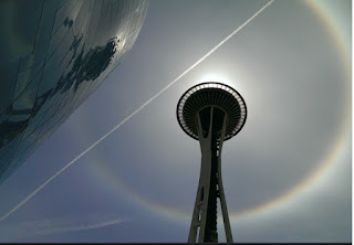
Today I received pictures from several of you regarding some wondrous halos in the sky.  Others noted an  impressive collection of contrails...and there is no accident that both apparitions appeared at the same time:  the ultimate cause is the same.

Here is a very nice picture from Brendan Fields showing both appearing at the same time!

And from Jules submitted to the Seattle Times:


 A high resolution MODIS image from today shows an extensive collection of high cirrus and cirrostratus clouds  and if you look carefully you will see lines:  those are contrails!


Halos occur when rising air in the upper tropospherc causes condensation and the formation of ice crystal clouds (cirrus and cirrostratus).   When the sun's ray's intersect the randomly oriented ice crystals, the light is bent preferentially by 22 degrees...thus producing a 22 degree halo.

Contrails occur then the air is very near or at saturation, and the addition of water vapor from the combustion in the jet engines causes the formation of a line the of clouds behind the plane.

So both halos and contrails are dependent on the upper troposphere (roughly the layer of the atmosphere from roughly 15,000 ft to 35,000 ft) become saturated or near saturated.   We can tell whether this is true of the real atmosphere by taking the observations from balloon-launched weather instrument radiosondes)  and plotting the temperature and dew point temperature on a chart (a.k.a. a sounding).

Below is the sounding from Quillayate, on the Washington coast, at 5 PM Saturday.  Note the temperature lines (red) and dew point lines (blue) are very close together from 500 hpa (around 18,000 ft) to around 350 hpa (around 25,000 ft).    The atmosphere is either at or close to saturation in this layer (saturation is evident when the temperature and dew point are the same) .

This saturated layer is associated with rising motion from an east Pacific trough/close low (see image of upper atmospheric flow at 2 PM this afternoon), the ultimate cause of both the halos and contrails seen today.


From Highs to Lows

As noted in my previous blog, the meteorology of much of the summer has been dominated by high pressure offshore, resulting in a warmer and ...