Here is Puget Sound country it is going to be a beautiful day...lots of sun and temps rising into the 70s. Look outside or view the latest visible satellite picture.
On the other hand the National Weather Service forecast RELEASED THIS MORNING paints a less optimistic picture.

And yesterday's forecast was even more pessimistic.
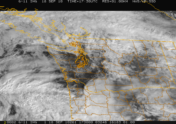
 The computer forecasts yesterday showed the break between systems (see example) and certainly this morning it was clear.
Why didn't the message about a spectacular break on Saturday get out?
I think there are three main reasons:
1. The National Weather Service forecast cycle is only updated every 6 hr in most cases and there is a lack of emphasis on nowcasting--describing what is happening now and during the next few hours.
2. There is a distinct tendency for the National Weather Service to broadbrush their forecasts--smear out clouds and weather over an extended period and not to put emphasis on breaks in the weather...even when they are pretty obvious.
3. Finally, there is the tendency in the NWS to maintain forecast consistency--staying with the same story--even when new guidance suggests otherwise. This is based on an internal philosophy not to jerk the forecast around as numerical guidance changes.
Personally, I think this all has to change...and in fact this blog is partially a reaction my feelings.
I believe that that providing frequent updates on current and expected weather is a hugely important area for development and that society has much to gain from this direction. For many of us, knowing what is happening and what will happen in the next 6 hrs is hugely important...and has great value for saving property and lives. To be fair, when severe weather is occurring the NWS does do more nowcasting, but I think they need to do so on a more regular basis.
In a day with smartphones, internet-capable cell phones, and computers on the internet everywhere, the ability to deliver real-time weather information exists. New software applications, better computer modeling, and a huge increase in observations will make the information available. We just have to put the package together--and society has much to gain from it.
The nightly weather on the local news is great, but people need weather information all the time...and we have to find a way of delivering it. An idea: every major city could have a nowcasting weather broadcast on the internet, updating the current weather situation every 15 minutes.


Thank you Cliff... something I have been frustrated about in recent years. The lack of NOW-CASTING, and updating the forecast. Many of my "colleagues" have their heads buried in the computer models or following their vendor generated "futurecast" over the "cliff" like lemmings. (no pun intended Cliff)
ReplyDeleteI have yet to see one of the locals disagree, or talk about how the "future-cast" is just flat out WRONG. As you point out there is sometimes the need to just use your eyes and poke a heads out the window, or looking at a satellite.
There seems to be a tendency also to take a C-Y-A attitude in the forecasts. In fact some of my colleagues have freely admitted to me they would rather over-forecast clouds and a chance of rain, rather than be caught missing a 10 minute sprinkle.
Make the call. If you get it wrong, remember you're only human.
Thanks again Cliff!
Larry Rice
Having up-to-the-minute and 10 minute forecasts would be incredibly useful for bicyclists. For weather in the next 30 minutes I go straight to the radar in the rainy months. If I can see a wave of non-rainy sections I will wait for it or jet out the door to make it while it isn't raining for my 15-20 minute window of a bike ride in town. Having a 10min, 30min and 1hr forecast of rainfall would be awesome.
ReplyDeleteI completely agree with you about the importance of more frequent updating.
ReplyDeleteMy partner & I work full time, sometimes different shifts, and have a small farm. We need to coordinate pretty tightly to get things done, and knowing we have a day of dry, even a few hours in advance, makes a huge difference in what outdoor projects we can complete before winter.
Keep up the good work!
Did anyone else stay up late and listen to last night's rainstorm? Mountlake Terrace, it was coming down until at least 2 am without a breath of wind. Very warm, felt like Hawaii.
ReplyDeleteCliff, you are so right the weather reports need way more frequent updating, as it unfolds differently from what was forcast.
ReplyDeleteEspecially here in Port Angeles, the reports we get are so often off. When storms come in and big winds are forecast, often we have nothing but almost still air here.
I always appreciate the information in your blogs. Now-weather or coming-soon-weather is what I'm actually interested most of the time. It was a nice surprise today to get a sunny opportunity to go out on the new stand up paddle board! Also, getting a chance for an hour or two of sun on a day with barely 10 hours of daylight really makes a difference during the darker times of the year.. Thanks for all the blog posts. I look forward to learning more in every one I read.
ReplyDeleteSusan
if you cannot see Mt Rainier, it is raining and if you can see Mt Rainer, soon it will rain--all forecasting is based on this simple principle.
ReplyDeleteLocal forecasters up to the minute?...I just heard today on local news the prognostication that we are going to experience a La Nina this winter...I believe I heard you say just that very thing a month ago when I bought my ski season pass...
ReplyDeleteIf I'd had a bit more advance info about the fine weather, I could have gone on a road trip to some local farms today without fear of getting doused. I missed that opportunity, but still enjoyed the sun. Bring on more now-casting! Thanks for the great article, Professor.
ReplyDeleteI would love more "now-casting" as well. It helps so much with any outdoor activity planning. I washed my car during the brief sunny period and was glad I caught it just in time!
ReplyDeleteHear hear! As a boater it TERRIFIES me that when a severe windstorm comes through, the NWS & NOAA rarely commit even to the possibility of high winds - until we are in the soup.
ReplyDeleteMuch was made of a charter delivery sailor who disappeared in the Hanukkah windstorm - "Why did he go back out when a storm was on it's way?" Because, landlubbers, a few local meteorologists was talking about it the possibility all week, but officially it was "15-25" until less than 24hrs before it hit.
I rely on the Net - in this day & age, instant text updates would be nice - and as your updates & Scott Sistek's reports show, you CAN "waffle" about the weather if you back it up with maps, data, & an explanation of the possibilities.
Thanks for that chance.
It goes without saying that the mariners around here would really benefit from more frequent forecasting!
ReplyDeleteHowever, what the NWS provides is light years better than the infrequent "CYA" forecasting for the BC coast put out by Environment Canada. I was up the Inside Passage and over to the Queen Charlottes this summer. They're in the weather forecasting dark ages up there.
The news cycle gives the weather in the morning and in the evening. The now cast is unavailable unless you look at the NWS website radar image and satellite image. So you end up doing your own now and half-an-hour-from-now forecasting. This too much to ask of the weather beaurocracy.
ReplyDeleteUnless a major front is blowing through, a forecast can only give averages. I've seen it rain on one side of the street and not on the other, frequently. We just move to a different tennis court.
The weather here hasa 50% chance of being unpredictable so buy some Gortex and get on with it.
What can happen in six hours: Notes from a bicycle ride Sept 18, 2010.
ReplyDeleteSaw a progression of weather this ride from 12:06 – 6:12. About 6 hours.
12:06 Green Lake. Ride started with clear blue skies with a high band of white clouds far to the south.
1:20 By Woodinville these clouds had advanced but still plenty of blue skies around, and could see the appearance of a mid deck of clouds on the south horizon just after left Woodinville. Reading the sky it looked like rain could move in within 2 hours and still lots of blue sky.
2:18 By the time I arrived at Redmond the leading edge of the high clouds were beginning to move over head with the mid deck not too far behind.
3:16 By Issaquah the progression of clouds continued with the mid deck moving in. The Upper and mid deck did not appear separate, but rather was a continuous thickening of the upper to middle deck over a short distance.
4:00-4:47 By Bellevue virga was obvious and light rain began almost immediately (This was about 4pm). Was in light rain all the way to west end of I-90 floating bridge. This was not a wetting rain, but rather pleasant to be in. It did stop briefly while riding across the north end of Mercer Island, but restarted. Could see rain clouds all over the south horizon to overhead. At I-90 overlook on the west end of the floating bridge, the rain towards the south end of Mercer Island and Renton looked heavier, so good call on not going around the south end of the island and riding across just the north end of the island. And sun disk visible through rain clouds in the west.
As rode north along Wa Blvd. the rain stopped and everything was dry. Could still see blue sky to the north and Mt Baker was basking in the sunlight. As I rode north rain was visible on the east side, with darker clouds to the east and southeast.
6:12 By the time I arrived home at Green Lake the clouds were thickening up and it began to sprinkle. Rain began at Green Lake soon afterwards.
Boeing Field temperatures 70-73-71. Note dew points 58-59! It did feel humid. Surprising how clear the air looked.
Nice job on the nowcasting piece; couldn't agree more. What I would love now is a little background on the volume of rainfall in the past few days, as well as some embellishment on the humidity. It's been downright tropical, and I'm wondering how much of this air mass and moisture can be attributed to spent tropical systems.
ReplyDeleteGlad you guys had great weather today... in Taiwan it was not so good. Taipei escaped the worst of the storm because when it hit the mountains in the middle of the island, it took a firm jog to the southwest... but we've still had significant winds and rain. Here's the history from a site near me: Taipei Airport readings, September 19, 2010
ReplyDeleteI guess you will end up getting this moisture eventually in Seattle, but probably not until after you get the moisture from the system that's boiling up near Guam.
Sorry to keep sending rain home... I can't find any postcards! ;-)
I agree with needing the now forecast. As a NW kiteboarder the 3PM forecast means a lot in predicting if we'll get enough wind to kite before dark. Last Monday my friend and I were commenting (laughing) at the 3PM Admiralty inlet forecast. It was blowing 18MPH at Pt. Wilson and the forecast that came out 15 minutes later said less than 10knots. This has happened so often this summer most of us have given up on NWS except for trends days out.
ReplyDeleteWell said, Cliff, as always. Logical and coherent in a world that seems to abhor logic and coherency.
ReplyDeleteBut your voice alone will probably not make this shift. What action steps can your readers take to complain/stir the pot/interrupt the prevailing thought stream? Write letters? To whom? Call?
How can we help?
We live off-the-grid and depend on 2700 watts of solar panels and a Honda generator for our electricity. We monitor the sky very carefully and try to coordinate use of our generator with days of little or no solar gain. Had I known that Saturday was going to be even partly sunny I wouldn't have used the generator on Friday to top off our battery bank. A gallon of gasoline wasted!
ReplyDeleteI boat a lot up in BC and there the weather is forecast every 6 hours. Plus they give you zone forecasts, e.g., Howe Sound, S Strait of Georgia, N Strait of Georgia, and more. But once I cross into the US, it is look at the sky and try to make sense of it because the weather forecast is 12 hours away.
ReplyDeleteSaturday morning, 9:15, we in the San Juans are having a serious, at least for us, thunderstorm. Been going on about an hour, and has gotten much closer and more significant in the past few minutes, lightening visible even through the fog, and heavy thunder. Not stuff we see very often.
ReplyDeleteThanks for raising this important issue. On more than one occasion in the past year, my husband and I have been sailing between Seattle and Port Townsend and the weather forecast from the NWS had little to do with actual conditions and the divergence has been extreme. For example, no wind when a small craft advisory is in effect or, more dangerously, winds above 30 knots, when light winds are forecast.
ReplyDeleteEven the NWS' VHF weather radio service is of little help in these situations. "Current conditions" for wind reports at wind stations in Admiralty Inlet and Puget Sound are often more than an hour and a half old, sometimes longer. And the fact that they are land based stations, even on wind-swept points, limits their value. And sometimes, the data broadcast is plain wrong. During our last trip, the station at Smith Island was clearly out of order. It broadcast winds of 8 knots from the West for several days straight. During our crossing of the Straight, the reality was 30+ knots from the East. Big difference. Ferry Weather, for areas where there are ferries, is a great help. Unfortunately, it covers only a small part of the area.
Given the same improvements in technology that you mention in your post, it is unclear why the NWS has not changed their model to provide "nowcasting". It would be of significant benefit to all recreational boaters. Since this is the group that is affected most by extreme weather on the water, the lack of up-to-date information about current and changing conditions is a very real public safety risk.
Trying to pin down natures dance with are iphones,ipads,radars,text messages,silicon chips, is like trying to figure out a conspiracy. It will never be good enough when technology promises the new thing and never be bad enough to stop complaining about it. Opps my iphone just said I have 10 minuets to enjoy the sun. Better go...
ReplyDeleteWeather forecast for tonight: dark. ~George Carlin
I found that a key to enjoying NW weather is to look at the sky for the nowcast, and plan accordingly. I used to view the NOAA animated to estimate how fast things were moving, and it worked well. Now we have your great blog... thanks!
ReplyDeleteVarious entities this area, both public and private are in tremendous need of accurate and timely forecasts for permit mandated stormwater monitoring programs. This work requires forecasts with precipitation totals that as accurate as possible so we can predict both the timing and volume of the resulting stormflow that we will need to sample. As part of a municipal stormwater monitoring team I have really appreciated the public access to the UW’s forecast models, but am also frustrated by the lack of forecasts that update as conditions change during the day. The lack of updates affects both the success of our monitoring programs and makes staffing very difficult. Weekends are the hardest, we have to use the available forecasts on Friday to make calls for weekend staffing, I have personally ruined people’s weekends by having them on-call during a sunny day and missed storms that were not expected. We are really looking forward to updated forecasts!
ReplyDeleteThanks for this site and your great work at UW!
Jim Crawford
Hi Cliff,
ReplyDeleteI use your blog for weather trends and http://www.wunderground.com/wundermap/ for NOW forecasting. If I just look upwind I can pretty much get a two hour forecast and for bicycling or sailing it's plenty accurate enough. All those little home stations of data are enough to know when to jet out or sit tight.
I hope someone's capturing all the wonderful stories and desires expressed here to help make the case for Cliff's approach to forecast management.
ReplyDelete