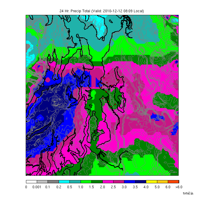
3-4 inches over the Kitsap and a band of 2.5-3 inches over N. Seattle and the eastern suburbs. In Snohomish County the rainfall declines rapidly. Less south of Tacoma. Here is the larger view..and keep in mind that you can't trust this over the Cascades, the coast and far to the south, since it is dependent on radar information. Huge totals over southern Vancouver Island (over 6 inches).
 In the Quinault Valley there has already been over 8 inches (by 4 AM). Mark Albright provided some more totals through 8 AM Sunday event totals (since 11 AM Saturday)
Seattle 2.67 Boeing Field 2.98 UW 3.09 Shoreline 2.24 Mountlake Terrace 2.12 Everett (Paine Field) 0.97
Arlington 0.62
Here are the totals from the CoCoRahs volunteer network for the 24-h period ending 7AM. Less than 1/2 inch over southern Whidbey Island and the adjacent mainland, while N. Seattle is getting 2-3 inches. Makes you believe in the rainshadow.
Here are the totals from the CoCoRahs volunteer network for the 24-h period ending 7AM. Less than 1/2 inch over southern Whidbey Island and the adjacent mainland, while N. Seattle is getting 2-3 inches. Makes you believe in the rainshadow.
 The heavy rain should continue throughout the morning and then decrease as as the band pushes south this afternoon. Where the amounts exceed two inches there is a real threat of slides/slope movements on steep slopes.
The temperatures have jumped into the 50s for much of the regions and strong southerly and southwesterly winds are over us. Look at the Seattle profiler temperatures and sustained winds over the past day (below) . Time runs from right to left (left is the most recent), the y-axis is height in meters. Temps (C) in red. Huge warming and look how strong the winds are above us. A solid triangle indicates 50 knots. A triangle and long line is 60 kts. 20-30 knot sustained winds right above us.
 You can just feel Hawaii.
.png)


"Here is the larger view..and keep in mind that you can trust this over the Cascades, the coast and far to the south, since it is dependent on radar information."
ReplyDeleteDid you mean to write "can't trust this"?
Near Woodland Park (Phinney side) it has been raining constantly and sadly I forgot to empty the rain gauge prior to this event. But I emptied it about an hour ago and we have almost a full inch in that time. Our basement is flooded, more than I can ever remember (it does flood in heavy rain). Sigh. Rain barrels have filled up many times over.
ReplyDeletewe received over 16" of wet snow last night here in the Lake Chelan valley (25 mile creek area) an amazing event. Too bad its so warm.
ReplyDeleteReally enjoy your blog.
I live on a boat in the Fremont area and Saturday at around 2:00pm I turned over a straight sided bucket and set it up to see how much rain fell. This morning at 10 am there were 4.1" inside. I know this is totally unscientific but it has been an amazing rainfall!
ReplyDelete2.3 inches on the west side of San Juan Island (just up the hill from the County Park)
ReplyDeleteDungeness River went from 300 fps to 4580 fps in less than 12 hours. They call it a rainfall dependent river and the statistics agree. Just over 7' flood stage at 10:00 AM. First view of the Olympics just now-rained quite aways up-maybe all the way to 7900'
ReplyDeleteIt's getting hard to fathom. It just goes to show that it is difficult to characterize a LaNina in terms of weather characteristics.
ReplyDeleteI remember reading that LaNina's typically have a lower incidence of flood events than say a neutral year. Looks like this LaNina year has broken that mold.
Cliff (or anyone who can help),
ReplyDeleteI know somewhere there's a website that tracks the river current depth and shows the flood stages in real time. I can't remember which website this was one, but I'm hoping someone has a link to the site that has this information.
I had a link for the Snohomish river (the one that concerns me), but lost the link a long time ago).
Any help would be appreciated. Thank You!
my house rain gauge, in the Central district/Madrona area of seattle, is at 3.3 inches in a little over 24 hours.
ReplyDeleteThis this for the Snohomish near Monroe: http://waterdata.usgs.gov/nwis/uv?12150800
ReplyDeleteI just got notified that we are at flood stage 2 in Green River Valley. Stage 3 would be something for us to worry about in Kent, but 2 is bad for folks up the river ahead of Auburn. Haven't been able to find a rain gauge for our area yet, but my bucket outside is half-way full already since yesterday.
ReplyDeleteAnother useful link, the Advanced Hydrologic Prediction Service:
ReplyDeletehttp://water.weather.gov/ahps2/hydrograph.php?wfo=sew&gage=mrow1&view=1,1,1,1,1,1,1,1
Here is WA river-flow current info:
ReplyDeletehttp://waterdata.usgs.gov/wa/nwis/current/?type=flow