September 30, 2010

Fall and Low Clouds

We are in for a stretch of beautiful fall weather, but many of our days will start off with low clouds and fog. And that is absolutely typical for this time of the year. In fact, we are now in the foggiest time of the year for central Puget Sound.

Why?

Night is getting fairly long, giving a good opportunity for the surface to cool off by emitting infrared radiation. And with a lack of clouds aloft, that radiation has a good shot at leaving our planet. Cooling the lowest layer of the atmosphere often produces saturation..and clouds or fog.

Take a look at the visible satellite imagery this morning at roughly 8:30 AM--lots of low clouds over the lowest elevations: Puget Sound and the Willamette Valley. You can also see some fog-filled valleys in BC.


One of the interesting things we learned when satellite imagery became available is that fog and low clouds tend to burn in from the sides towards the center. Watch it happen today in the images below:


11 AM...you can also see the arid areas of eastern WA and Oregon (lighter colors)

2 PM...almost all gone.

The low-level cool air associated with clouds is quite apparent on the Seattle profiler (see below). This figure shows you the temperature variation with height from 5 AM (yellow) through 11 AM (black). Height is in meters. The cold air is about 400 m (1300ft) deep, with a strong inversion (temp increasing with height) above.

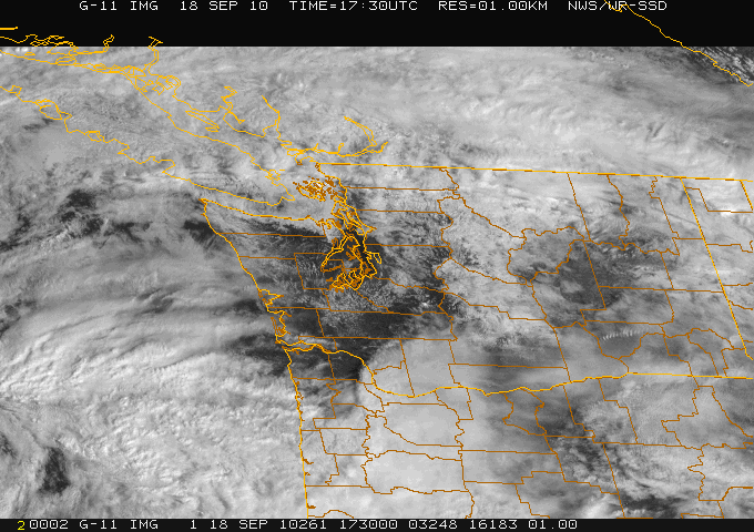
If you had hiked up Tiger Mountain or some other lowland peak this morning, the temperatures would have warmed by nearly 10C (18F) in 200 m (650 ft)--something you would have noticed. Such inversion conditions are often evident in fall. So if it is cloudy in the lowlands, don't give up on your hike. Check the satellite picture and it may be clear and warm above.

September 27, 2010

Incredible Humidity

Today the humidity has been extraordinary around western Washington and Oregon. I mean sticky. Feels like the southeast U.S. during the summer--and for good reason: we are experiencing very, very high humidities with dew points in the mid to upper 60s in many locations.

(Remember dew point is a very good measure of humidity...high dew points mean lots of water vapor in the atmosphere. Typically this time of the year dew points would be around 50F. )

Here are some dew point values at 5 PM:

UW 67F
Olympia 69F
Tacoma 67F
Portland 63F
Cascade Locks 72F

There is a satellite that senses water vapor from space...take a look below:

Pretty amazing...there is a plume of moisture streaming out of the subtropics from just north of Hawaii....an atmospheric river. You can call it a pineapple express--but it is missing one thing...enough upward motion to give us heavy rain. Want to see a great video of this moisture plume? Check this out:

http://cimss.ssec.wisc.edu/tropic/real-time/tpw2/epac/main.html

Here is a simulation of vertically integrated water vapor from the UW forecasting system valid 11 PM...the blues are the highest values and you can see it streaming from the southwest.

The humidity is so large that there has been some condensation in the form of shallow fog over parts of the Sound...which is cold enough to cause this moisture to condense. Some wind was also helpful, since it mixed the water vapor towards the cold surface. Look at this picture sent to me today by Greg Johnson of SkunkBayWeather.com. You see the grey haze near the surface? That is the shallow fog I was talking about.

Now I know for sure that this was the most humid day over the past year so far in terms of dew point ---and here is the proof for Sea Tac:

At Sea Tac the highest dew point of the day was 66F...one degree shy of the ALL TIME RECORD HIGHEST SEPTEMBER DEWPOINT for that location.

And want more extreme weather...head to the LA basin for heat. A number of locations have had their ALL TIME RECORD TEMPERATURES, with observations in the LA area of 113-119F!! Be thankful you are living in the Northwest.

September 25, 2010

The Rain Cometh

Today was as close to perfect as weather can get around here. In Seattle: no clouds, high in the mid-70s, nice breeze. The air was clean and visibility was excellent.

But this will be a weekend with a different ending and the change is moving in right now.

Here is the latest radar image from the NWS Camano Is. radar. You see all those greens and yellows in the upper left-hand portion of the image...that is moderate rain associated with a well-defined frontal band that is now moving into western Washington. The echos over the Puget Sound region are probably birds.


The frontal band that is moving in is quite clear in the latest infrared satellite image (see below). You will also note there isn't much immediately behind it...a different story from our normal wintertime frontal passages, which are followed by cold air showers.


One amazing thing about today were the clear skies....I mean NO clouds at all and great transparency to the atmosphere. You want to see the proof? Below are the observations taken on the roof of my building at the UW for the past 72 h (click to expand). The lowest panel shows solar radiation. Thursday and Friday the amount of solar radiation was greatly lessened by clouds....but look at today. Amazing. Almost a perfect sinusoidal shape--could have been from a textbook.


OK, time to stop raving about today.

The front is moving in quickly and rain should hit the interior lowlands overnight and spread over the Cascades in the morning. Here is the forecast 24-h rainfall ending 5 PM tomorrow. Fairly heavy rain (up to 2.5 inches) for the western side of the Olympics, the mountains of Vancouver Is and the north Cascades. The WA coast will be wet. And a general decline to the south and east. Head to the Tri-cities and Hood River if you want to stay completely dry. The front will weaken as it makes landfall.


Many of us are hoping for lots of rain from this event. The all-time wettest Sept for Sea Tac is 5.95 inches and we have nearly 4.4 inches now...a big hit tomorrow could make up half the gap! But we don't have much time.

Some notes:

On Wednesday night there will be a meeting of the Puget Sound Chapter of the American Meteorological Society here in Seattle (see info to the right). This gathering is open to all and it will be a great opportunity to hear the latest on the upcoming winter from a national expert from the National Climatic Center.

On Saturday, Oct 2, I will be doing two events---that night I will be giving a lecture in Bellingham at 7 PM on the extreme weather of NW Washington...and believe me they have a lot to brag about (see info to the right).

That morning I will be doing a book event (e.g., signing books and talking to people) at the south Seattle Costco from 9:30-11:30 AM (http://www.washington.edu/uwpress/calendar/cal_event.php?id=265). Other UW Press authors will be there as well.

September 23, 2010

The First Atmospheric River of the Season

Some of the most important wintertime weather features of our region are the plumes of moisture that stream northeastward out of the tropics and subtropics. In the discipline these plumes are often called "atmospheric rivers" and the atmospheric river that is often discussed in the media is the "pineapple express." This weekend the first major atmospheric river of the season will strike our region, specifically central and northern Vancouver Island and adjacent portions of British Columbia.

Here is a recent computer forecast of the amount of water vapor in the atmosphere (the fancy name is "column-integrated water vapor"--throw that around and you will impress your friends!) for 11 AM on Saturday. The blues are high values-see the atmospheric river?


The plumes of atmospheric moisture associated with these rivers is usually associated with warm temperatures--in fact it HAS to be that way, because only warm air can hold large amounts of water vapor. When this warm juicy air strikes our mountains it is forced to rise--the result being large amounts of precipitation. Want to see what the models are going for? Here is the forecast 24-h rainfall ending 5 PM on Sunday. The reds are FIVE TO TEN INCHES OF RAIN! There is even a white area, where more than 10 inches is predicted.


Fortunately for us, the U.S. side of the border will only get a weakened share of this wet bounty--after a generally dry Saturday the front that is associated with this precipitation will move through rapidly, with only modest showers over western Washington.

Do we expect a lot of strong atmospheric rivers this year? Will one hit the weakened Howard Hanson Dam? What I can tell you is that the upcoming winter will be a La Nina period and generally the strongest atmospheric rivers and floods are during neutral years (neither La Nina or El Nino). So although we expect this fall and winter to be wetter than normal (due to La Nina), there is less chance for a mega-rain/flooding event. Yes, it could happen, but it is less likely.

September 19, 2010

Northwest Monsoon

I have been amazed by the amount of rainfall falling around here over the past two days, with a number of locations getting the equivalent of an entire September's rainfall in 48hr! Warm, humid, and tropical. At my home in north Seattle I had 1.1 inches the first day and 1.05 inches the second! The ground is saturated.

Take a look at the 48-h rainfall analysis from the Seattle Rainwatch web sight (built by the UW and sponsored by the City--Seattle Public Utilities--to allow them to deal with heavy rainfall situations, http://www.atmos.washington.edu/SPU/). Areas from Seattle extending back to Tahoma had over two inches.Here is a wide view...keep in mind Rainwatch is based on calibrating radar imagery using rain gauges and thus is not useful where terrain blockage is significant (over the Cascades, WA Coast for example). The heaviest rain was apparently near Olympia.Olympia has accumulated 4.1 inches of rain in just the past 4 days and 5.3 inches over the past 31 days. September normal at Olympia is 2.0 inches for the entire month.

Over the past 4 days SeaTac has recorded 3.2 inches of rain, normal for the entire month is 1.7 inches. Want more? For the calendar day yesterday Seattle set a new daily record (.78 inches) ...old record .57 inches in 1983. Want even more? So far this month (ending midnight) Sea Tac has received 3.74 inches, which IS THE WETTEST
18 days on record for September at that location. Olympia has the same claim. The all-time wettest Sept for Sea Tac is 5.95 inches and 7.59 inches for Olympia. A really good chance we will break these records.

If you have a sprinkler system, better turn it off.

I was planning on getting my house painted this fall...I have had second thoughts with all this rain!

Why has it been so wet? For several days we have had a persistent configuration of the upper level flow with a low offshore and southwesterly flow over us and Oregon (it has been even worse down there!). With strong SW flow we have had a warm, moist, unstable air streaming over us for days.


Latest NWS Statement released Monday AM:
835 NOUS46 KSEW 201154
PNSSEW

PUBLIC INFORMATION STATEMENT
NATIONAL WEATHER SERVICE SEATTLE WA
450 AM PDT MON SEP 20 2010
..WET LAST FEW DAYS FOR WESTERN WASHINGTON ESPECIALLY THE PUGET SOUND REGION...

NUMEROUS PRECIPITATION RECORDS WERE SET DURING THE LAST FEW DAYS OVER THE INTERIOR OF WESTERN WASHINGTON.

SEATTLE

THE SEATTLE-TACOMA AIRPORT RAIN TOTAL FOR THE LAST FOUR DAYS WAS 3.23 INCHES ( 0.60 ON THE 16TH...1.49 INCHES ON THE 17TH...0.78 INCHES ON THE 18TH AND 0.36 INCHES ON THE 19TH ). NORMAL FOR THE ENTIRE MONTH OF SEPTEMBER IS 1.63 INCHES SO NEARLY 200 PERCENT OF THE MONTHLY NORMAL WAS RECORDED IN THE LAST FOUR DAYS. 3.23 INCHES WOULD BE THE 12TH WETTEST SEPTEMBER ON RECORD AT SEATTLE-TACOMA AIRPORT IN THE 66 YEARS RECORDS HAVE BEEN KEPT AT THE AIRPORT
( RECORDS STARTED IN 1945 ).

DAILY RAINFALL RECORDS WERE SET ON THE 17TH AND 18TH

17TH 1.49 INCHES...OLD RECORD 1.26 INCHES SET IN 1969
18TH 0.78 INCHES...OLD RECORD 0.57 INCHES SET IN 1983

RECORD ONE HOUR AND TWO HOUR RAINFALL FOR SEPTEMBER WERE SET.

11 PM TO MIDNIGHT ON THE 17TH 0.63 INCHES (OLD RECORD 0.54 9/8/79)
11 PM 17TH TO 1 AM ON THE 18TH 0.94 INCHES (OLD RECORD 0.60 9/22/78)

RECORD THREE DAY SEPTEMBER RAINFALL RECORD WAS SET 16TH THROUGH THE 18TH

2.87 INCHES...OLD RECORD 2.82 INCHES SEPTEMBER 20-22 1972.

RECORD FOUR DAY SEPTEMBER RAINFALL RECORD WAS SET 16TH THROUGH THE 19TH

3.23 INCHES...OLD RECORD 3.10 INCHES SEPTEMBER 19-22 1972

IT WAS THE SECOND WETTEST TWO DAY TOTAL ON THE 17TH AND 18TH...
2.27 INCHES. RECORD 2.36 INCHES SEPTEMBER 22 AND 23 1978.
THE 1.49 INCHES ON SEPTEMBER 17TH WAS THE FOURTH WETTEST SEPTEMBER DAY ON RECORD AT SEATTLE-TACOMA AIRPORT SURPASSED ONLY BY 1.65 INCHES ON SEPTEMBER 22ND 1978 AND SEPTEMBER 30TH 1953 AND 1.51 INCHES ON SEPTEMBER 26TH 1948.

MONTHLY RAINFALL TOTAL THROUGH THE 19TH AT SEATTLE-TACOMA AIRPORT IS 4.10 INCHES. THIS IS CURRENTLY TIED FOR THE FOURTH WETTEST SEPTEMBER ON RECORD. THE RECORD IS 5.95 INCHES SET IN 1978.

TOP 5 WETTEST SEPTEMBERS AT SEATTLE-TACOMA AIRPORT

1. 5.95 INCHES (1978)
2. 5.57 INCHES (1969)
3. 4.60 INCHES (1959)
4. 4.10 INCHES (1972) AND 2010.

THE 4.10 INCHES THROUGH THE 19TH IS THE WETTEST FIRST 19 DAYS OF THE MONTH ON RECORD SURPASSING THE PREVIOUS RECORD OF 3.10 INCHES SET IN 1959.

OLYMPIA

THE OLYMPIA AIRPORT RAIN TOTAL FROM THE 15TH THROUGH THE 18TH WAS 4.09 INCHES ( 0.66 ON THE 15TH...0.91 INCHES ON THE 16TH...1.67 INCHES ON THE 17TH AND 0.85 INCHES ON THE 18TH ). NORMAL FOR THE ENTIRE MONTH OF SEPTEMBER IS 2.03 INCHES SO OVER 200 PERCENT OF THE MONTHLY NORMAL WAS RECORDED BETWEEN THE 15TH AND 18TH. 4.09 INCHES WOULD BE THE 8TH WETTEST SEPTEMBER ON RECORD AT OLYMPIA AIRPORT IN THE 63 YEARS RECORDS HAVE BEEN KEPT AT THE AIRPORT ( RECORDS STARTED IN 1948 ).

DAILY RAINFALL RECORDS WERE SET ON THE 17TH AND 18TH

17TH 1.67 INCHES...OLD RECORD 1.13 INCHES SET IN 1969
18TH 0.85 INCHES...OLD RECORD 0.75 INCHES SET IN 1983

THE 17TH WAS THE WETTEST SEPTEMBER DAY ON RECORD AT OLYMPIA AIRPORT BREAKING THE RECORD OF 1.54 INCHES SET SEPTEMBER 6TH 2009.

RECORD THREE DAY SEPTEMBER RAINFALL RECORD WAS SET 16TH THROUGH THE 18TH

3.43 INCHES...OLD RECORD 3.24 INCHES SEPTEMBER 15TH-17TH 2010. OLD RECORD BEFORE THAT 3.14 INCHES SEPTEMBER 20-22 1972.

RECORD FOUR DAY SEPTEMBER RAINFALL RECORD WAS SET 15TH THROUGH THE 18TH

4.09 INCHES...OLD RECORD 3.54 INCHES SEPTEMBER 20-23 1972

IT WAS THE THIRD WETTEST TWO DAY TOTAL ON THE 16TH AND 17TH...2.58 INCHES. RECORD 2.66 INCHES SEPTEMBER 22 AND 23 1978...SECOND
2.62 INCHES SEPTEMBER 20TH AND 21ST 1972.

MONTHLY RAINFALL TOTAL THROUGH THE 19TH AT OLYMPIA AIRPORT IS 4.95 INCHES. THIS IS CURRENTLY THE FOURTH WETTEST SEPTEMBER ON RECORD. THE RECORD IS 7.95 INCHES SET IN 1978.

TOP 5 WETTEST SEPTEMBERS AT OLYMPIA AIRPORT

1. 7.59 INCHES (1978)
2. 5.23 INCHES (1969)
3. 5.04 INCHES (1972)
4. 4.95 INCHES 2010
5. 4.58 INCHES (1977)

THE 4.10 INCHES THROUGH THE 19TH IS THE WETTEST FIRST 19 DAYS OF THE MONTH ON RECORD SURPASSING THE PREVIOUS RECORD OF 4.00 INCHES SET IN 1978.

$$

FELTON

September 18, 2010

Forecasting's Achilles Heel

Today we are experiencing a noticeable forecast failure and one that in some sense is self-inflicted.

Here is Puget Sound country it is going to be a beautiful day...lots of sun and temps rising into the 70s. Look outside or view the latest visible satellite picture.


On the other hand the National Weather Service forecast RELEASED THIS MORNING paints a less optimistic picture.


And yesterday's forecast was even more pessimistic.


The computer forecasts yesterday showed the break between systems (see example) and certainly this morning it was clear.


Why didn't the message about a spectacular break on Saturday get out?

I think there are three main reasons:

1. The National Weather Service forecast cycle is only updated every 6 hr in most cases and there is a lack of emphasis on nowcasting--describing what is happening now and during the next few hours.

2. There is a distinct tendency for the National Weather Service to broadbrush their forecasts--smear out clouds and weather over an extended period and not to put emphasis on breaks in the weather...even when they are pretty obvious.

3. Finally, there is the tendency in the NWS to maintain forecast consistency--staying with the same story--even when new guidance suggests otherwise. This is based on an internal philosophy not to jerk the forecast around as numerical guidance changes.

Personally, I think this all has to change...and in fact this blog is partially a reaction my feelings.

I believe that that providing frequent updates on current and expected weather is a hugely important area for development and that society has much to gain from this direction. For many of us, knowing what is happening and what will happen in the next 6 hrs is hugely important...and has great value for saving property and lives. To be fair, when severe weather is occurring the NWS does do more nowcasting, but I think they need to do so on a more regular basis.

In a day with smartphones, internet-capable cell phones, and computers on the internet everywhere, the ability to deliver real-time weather information exists. New software applications, better computer modeling, and a huge increase in observations will make the information available. We just have to put the package together--and society has much to gain from it.

The nightly weather on the local news is great, but people need weather information all the time...and we have to find a way of delivering it. An idea: every major city could have a nowcasting weather broadcast on the internet, updating the current weather situation every 15 minutes.

September 16, 2010

How Bad Has It Been?


Another round of rain struck today and the grumbling has increased...

"The worst summer I can remember"
"I thought Septembers were good around here"

and other comments that cannot be repeated on a family friendly blog.

Looking at the temperature versus normal for the past four weeks, tells the recent tale (see below). Except for a few brief warm periods, most days have been below normal.
Today was particularly noteworthy: the temperatures hardly fell last night and the humidity was palpable.
Dewpoints were in the low to mid 60s today...which is very, very unusual around here. It felt like the East Coast during the summer! Here is a plot of dewpoint for the past six months (click to expand). Remember, dewpoint is a measure of the amount of moisture in the air...the temperature to which you have to cool it to get saturation. Yesterday, was the highest dewpoint in SIX MONTHS.


I asked UW staff member Neal Johnson to plot up the number of days equal to or greater than 70F from January 1 through September 15th for this year and all other years since 1948 (see below). The results?

(click to expand)

We had far fewer 70F days (55) than normal (72) and in fact this has been the worst year by this measure since 1980! Yes, the worst summer for three decades! No one younger than 35 can remember anything worse! 1980 was comparable, and then you would have to go back to 1954 and 1955, which were even cooler, believe it not.


Tomorrow (Friday's) forecast? Rain coming in during the afternoon. You don't want to know about the weekend--even eastern WA will get wet.

One final thing...I will be giving a talk in Bellingham on the fascinating, and often extreme, weather of Northwest Washington on October 2 at 7 PM. See details in the upper right hand corner of this blog.

September 14, 2010

The Birds Are Back


I have mentioned before that birds can be viewed on weather radar, and we have a great example tonight.

It seems like the big migrations tend to occur at night (less chance of being caught by predators?). Here is the radar image that shows the amount scattered by targets in the atmosphere (we call this reflectivity) at 5 PM. Not much there, just ground clutter and some weak returns from a few birds, planes, density discontinuities in the atmosphere.

But here is at 8 PM....the sky is filled with echos..the birds!


And which way are the birds going? We can tell, because we have Doppler Radars, which reveal the velocity towards or away from the radar. Cold colors (e.g., green) indicate a velocity towards the radar, warm colors (e.g, yellow) motion away. Clearly, the birds are generally heading to the south or southeast, just what one would expect.


This is is good time for the birds to get going---it is about to get wet here again, as a frontal system makes landfall later tomorrow.

September 12, 2010

Go South for Sun! Wine weather.

During the fall, the jet stream and its associated weather strengthen and move southward. As a result our region gets increasingly "clipped", starting with the north. Today and late yesterday are a classic cases.

A weak front is now bringing clouds, rain, and cooler temperatures north of Seattle, while to the south it is dry and much warmer. Head to Portland and you can enjoy a warm sunny day. Here is the latest weather radar image:

The northern rain is apparent. You don't see much rain over the mountains...but don't believe it. The Camano Island radar is substantially blocked by the lower foothills and we can't see what is happening at higher elevations very well. You can also see a bit of the Olympic Mountain rainshadowing.

Here is the new visible satellite picture. Clear in Portland and over SE Washington. And if you look closely you can see wave clouds east of the Cascade crest.
Eastern Washington needs all the sun it can get so the grapes can ripen. With a cool spring and late summer, the maturation process is well behind according to some reports:

http://www.wawinereport.com/2010/09/perfect-storm-does-washingtons-2010.html

Interestingly, the author describes 2010 as a meteorological "perfect storm" for wine, with periods of above normal and below normal temperatures and excessive precipitation that leads to mold and mildew. The quality of the NW wine crop is not simply of academic interest for many of us!

Here is are the temperatures at Pasco the last two weeks. Most days are are not getting to normal and nighttime temps are dropping into the low 40s. And the downward trend is very clear.

After our front moves through today, there should be an improving trend for a few days. But let me be honest: current forecast models indicate a very wet weekend coming up. That could change of course as we get closer, but this solution has been quite stable. If still there on Wednesday's runs, it will probably be a reality.

September 09, 2010

The Long-Term Forecast

Many of you have asked for the details of the long-term forecast: what is expected for this fall and winter. OK, you asked for it--and some of you may not like what you hear.

The most powerful tool we have for predicting months ahead of time is the correlation between El Nino/ La Nina and Northwest weather. You have heard me talk about this frequently on this blog--the tropical Pacific sea surface temperatures oscillate between cooler than normal conditions (La Nina) and warmer than normal conditions (El Nino) over a period of roughly 3-7 years. And it turns out there is a strong correlation between the temperature of the tropical Pacific and the general character of our weather.

During the past half year the tropical Pacific has decidedly turned toward La Nina, with cooler than normal temperatures now evident near the equator. Here is the latest graphic: blue indicates more than .5C cooler than normal.


The figure below shows you the time evolution of this cold water...take a look at the Nino 3.4 area, a zone in the equatorial Pacific that is most often considered. Last year we had an El Nino (warm anomalies--an anomaly is the difference from normal) and during the early summer we rapidly slid into colder temps. We now have a moderate La Nina and it may well become a strong one. Computer models of La Nina evolution run by the National Weather Service and others are predicting a continuation of the La Nina through the winter.


Now the interesting thing is that the temperature of the tropical Pacific influences weather throughout the Northern Hemisphere, including us. Perhaps some day I will tell you why that happens, but in this blog let me give you the bottom line.

La Nina years are generally associated with wetter than normal conditions during the fall and winter, something I bet you believe after the last few days of liquid sunshine.

Here are official NWS average precipitation anomalies (again differences from normal) for fall and winter. The Northwest is wetter than normal in both, and you will note that California is relatively dry.
Now what about temperature? Turns out there is little temperature signal for La Nina years during fall, but during winter (January-March) we are colder than normal, as shown in this graphic:So colder and wetter than normal in winter....what do you think that implies? Yes, more SNOW, particularly in the mountains (see the graphic, where blue indicates more snow than normal). A good year to risk a season pass at a local ski area.
It also turns out that there is a greater probability of lowland snow west of the Cascades during La Nina years. Now, if Seattle's Mayor McGinn knows whats good for him he would be sharpening those snow plow blades, securing lots of sand and SALT, establishing rational plans for plowing the city, and telling all snow plow operators to avoid his neighborhood. We lost one Mayor to snowappocalypse, two would be an embarrassment. I offered to build a SNOWWATCH web page for the city...no bites yet.

The Next La Nina Victim?

September 06, 2010

Cloudy and Cool

I got back from a meeting at Lake Tahoe yesterday (American Meteorological Society Mountain Meteorology conference) and I am ready to get back on the plane to Reno. For September, which has often been a very good month around here, we are seeing cool, cloudy, and wet conditions west of the Cascade crest and north of Salem. Look at the latest satellite picture: you can see a week front moving over our region, but sun and warmth just to the south and east. If it makes you feel better,there are low clouds over coastal southern CA.


Looking at the actual temps versus climatology (image below). Over the last four weeks, and particularly since 21 August, we have generally been well below normal. Today was the worst of the worst.
You want to get more depressed? Here are the latest NWS extended forecasts (6-10 days). Below normal temps and above normal precip.

The problem is that we are locked in a pattern that keeps us cool, with persistent troughing (low pressure) over our area. Here is the upper level flow at 5 PM: ridging offshore and a trough moving into our area.


Tomorrow at the same time this trough deepens and extends down the coast, so that those smug folks in CA will get a big hit of clouds and some precipitation. We will be north of the action, which believe or not, is good for us...perhaps there will be a few breaks in the clouds in the afternoon.

Bottom line: cooler than normal, but not much precipitation. One good thing though--when I got home I rushed over to my vegetables--some of the tomatoes had turned red! Miracles do happen.

September 02, 2010

Hurricanes and Uncertainty


Now that Northwest weather has returned to the more usual and benign September fare, lets turn to hurricane forecasting.

An interesting factoid: My profession has made huge progress in predicting hurricane tracks, but there has been little headway with hurricane intensity predictions.

Here are the official statistics for Atlantic hurricanes. First, for track (position) error. Big progress, particularly for the longer-range predictions. The 120h forecast today has roughly the same skill as the 48-h forecast in 1970. That's progress!


The intensity forecasts have gotten worse (since 1970) at 24-h and are only slightly better at longer time ranges.


Now why this difference?

For track or position forecasts, we need to predict accurately the large-scale conditions around the storm. You can think of a hurricane as a spinning top that is being steered by the larger scale atmospheric environment. With more observations and better computer models we have gotten very good in determining this environment and therefore the track forecasts have dramatically improved.

But for intensity forecasts one must predict the inner workings of the storm and that is MUCH harder. First, you need to have enough information to determine the detailed three-dimensional structure of the storm...something we generally don't have. Then you must simulate the storm evolution and it takes very high resolution to model the eyewall and rainbands realistically. Current hurricane models are not run with sufficient resolution. And one more thing...we also need to correctly predict the interactions of the atmosphere with the tropical oceans, and right now we are not doing a good job at that. For all those reasons, we just don't do well with the intensity predictions.

But this could change quickly if sufficient resources were provided--including more powerful computers for the National Weather Service, better observations in hurricanes, and other realizable technological improvements. Unfortunately, the National Weather Service is acutely lagging behind in computer technology and a few weeks ago their request for an update of their main computer system was rejected by the Office of Management and Budgets. Our national weather prediction effort is in danger of falling to third-class status....but that subject should wait for another blog.

Should I Let AI Write My Blogs?

I spend a lot of time thinking about and writing my blogs.   Could AI apps do the work for me?   Could any of you tell the difference? Well,...