Why in the world would ocean temperatures get cooler during summer?
First, take a look at the sea surface temperature at Buoy 27, just off the CA/OR border. A cooling trend from roughly 47.5F to 45F...wow, the water is cold there. And there is a strange jump in temperature to 52F for a short period on June12th and 13th.
Here is a plot of Pacific water temperature, with dark blue being the coldest: cold water is found along the coast. Very strange!
The reason for this coastal cold water and the cooling during the summer is upwelling....cold water coming up from below in the coastal zone. Strangely enough, this upwelling is forced by our summer weather pattern in which high pressure builds offshore--with this high pressure producing northerly (from the north) flow along the coast. The northerlies are further strengthened by the warming of the interior and the resulting lower pressure (warm air is less dense). You note the very large difference in pressure over northern CA and southern Oregon.
 |
| solid lines are isobars...winds are roughly parallel to them over the ocean |
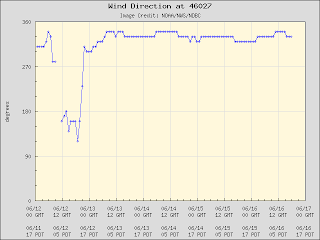
Now lets see if we can prove this is happening. Here is a plot of the wind direction at Buoy 27....360 or 0 is north, 180 is south, 200 is NW...you get the picture. From mid-May until early June the winds were all over the place, but recently they have pretty much stuck with NNW.
Here is a blow-up of the last week...north-northwesterly all the time except a short period of southerly winds on June 12th and 13th...exactly when we had the spike up of temperature. During southerly flow the upwelling fails..in fact, you can get downwelling...which is associated with warmer temperatures.
So don't expect to be swimming in the coastal Pacific during the summer...the upwelling refrigerator will keep things uncomfortable if not dangerous. Plus, there is all the debris from Japan....


Don't worry, Cliff. Anyone who has been to the Pacific Ocean off WA, OR, or CA knows it is c-c-c-cold. Summer, Fall, Winter, and Spring.
ReplyDeleteNow, please, give me some good news on my tomato plants setting tomatoes, for gosh sake...
Yes, the Invasive Species with the Japanese tsunami dock came in from the Briny Deep last week! And Today, maybe because that N/S Pressure Difference Set Up, there was a Big Oregon Quake Offshore! I just moved to Port Angeles and it is always a cold refrigerator here, apparently! I've noticed down at the waterfront, the Tides come in at an angle...from the North!
ReplyDeleteHow does the, Pacific Decadal Oscillation, I have been reading about play into this?
ReplyDeleteThere have been some questions...this relationship does not have to do with Pacific Decadal Oscillation or El Nino/La Nina...they are completely different features and of a longer time scale.
ReplyDeleteCliff,
ReplyDeleteThanks for remembering our part of the world down here in northern California. You are absolutely right. The waters have been very cold over the last couple weeks due to the northerly winds and upwelling. Surfers and other water enthusiast here know this acutely. It's fun to watch the change in SST here: http://polar.ncep.noaa.gov/sst/oper/nepac_sst_oper0.png. It also has a direct impact on the fishing industry as well, with nutrient rich waters rising to the surface, but a fisheries person could go more into that one. With pattern a change on the near horizon, SST should be on the rise. So we'll go from 45F back up to 50F. Yeah? Still, hypothermia only takes a handful of minutes to set in at these temps. Thanks again, great post.
Brian
Cliff, can you comment on the flooding in Duluth? I know it is not the PNW, but that was some huge rainfall!
ReplyDelete