Sometimes during springtime one looks at the visible satellite imagery over the eastern Pacific and can't help but be impressed that nearly the entire ocean is covered by low clouds. This morning provides a prime example:
Pretty amazing. You have to feel sorry for those poor mariners crossing the ocean with day and day of low clouds (mainly stratocumulus). Even central and southern California coastal residents are in the murk and you can see the low clouds spreading to the crest of the Oregon and Washington Cascades. Folks, this is what June gloom looks like from space.
You see the checkerboard pattern over the ocean? Those are ship tracks....the result of the effluent from fossil fuel burning ships. The particles from combustion result in more condensation nuclei and more water droplets. More droplets results in more of the sun's rays being reflected back to space. Here is a close-up view. You can see why the U.S. Navy likes nuclear ships...no ship tracks!
To illustrate the murk at ground level, here are the latest webcams at Cannon Beach Oregon:
and at Del Mar near San Diego.
Kind of makes a Northwestener feel better...we have have company.
The ironic thing about this extensive shield of low clouds is that it is the result of HIGH PRESSURE.
Don't believe me? Well, here is the proof...the 6-h forecast for sea level pressure over the eastern Pacific. A huge high pressure area dominating the eastern Pacific, while low pressure is found over the southwest U.S.. Between the two there is a large difference in pressure near the Oregon/CA border...which produces very strong winds there (described in a previous blog).
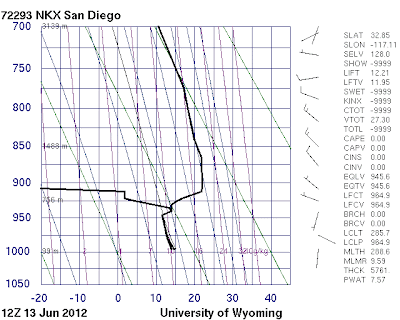
High pressure produces sinking air and sinking causes warming. The sinking decreases as the air approaches the surface. So with strong warming aloft and cool water near the surface we end up with an inversion (warming with height) in the lower atmosphere. So we have a veneer of cool, moist air (with lots of low clouds) near the surface and dry warm air aloft. Here is the latest sounding from Quillayute on the Washington coast (red is temperature, blue is dewpoint)... this structure is really obvious.
The vertical axis is pressure. 850 hPa is roughly 5000 ft. Where the temperature and dewpoint are on top of each other we have a saturated (cloud-full) environment. Here is a similar figure for San Diego (no color coding of lines). Same structure.
So the secret of getting away from the low clouds is either to go above roughly 3-5 thousand feet (good if you own a helicopter or can hike up a local peak) or cross the Cascades. Sorry.
This blog discusses current weather, weather prediction, climate issues, and current events
Subscribe to:
Post Comments (Atom)
"Perfect Storm" Rainfall Comes to the Northwest
It has happened multiple times this past year. After an extended dry period, the circulation pattern changes, bringing wet conditions tha...

-
Today may be the last day you will need air conditioning this summer in western Washington. And fears of wildfires west of the Cascade cres...
-
For those worried about Pacific Northwest drought, I have some news that should give them substantial comfort: substantial rain and snow wil...


Interesting. Can definitely see the inversion in the 800-900 hPa region. It looks very warm a loft in San Diego, and much cooler up north, but still the inversion. NEVERTHELESS, after today, I don't see any rain in the forecast for the Seattle area-- There a variable amounts of clouds and a good bit of sunshine in the 10-day forecast. Althought weather.com says change of showers on the weekend. High Temps around 20C +/-. Looks like the onset of summer.
ReplyDelete\
Cliff, although I see what looks like typical June weather on your photos and maps, still my overall sense this year is that there are a few more closed lows and fast moving troughs than usual.
ReplyDeleteIs that my imagination?
Thanks
http://earthobservatory.nasa.gov/IOTD/view.php?id=78208
ReplyDeleteKinda neat Aqua MODIS image from near Australia a couple weeks back showing the effects of a high pressure system on ocean clouds.
Cliff, so if i high produces clouds over the ocean and a low produces cluods over the ocean, how does the ocean get clear weather?
ReplyDeleteIt seems to me that s high, with it's subsiding warm, dry air should not see condensation at the surface UNLESS there is considerable water temperature contrast so that advection fog can form. That is, air at the surface becomes saturated over warmer water, and then that clear but humid air moves over cooler water, were it gets cooled below it's dewpoint. Am I correct?
Ansel
Do you think the June gloom will be over as we get closer to the Solstice? I'm getting married June 23 in an outdoor wedding and currently it is forecasted to be cloudy, but no rain! I'm hoping for sunshine!
ReplyDelete