Potentially one of the warmest autumns in years.
And this is exactly what the National Weather Service's long-range forecasting system is predicting.
We start with "the blob", the highly persistent area of warm water west of the Northwest coast (described in my previous blog). The sea surface temperature anomaly (difference from normal) for the first 8 days of September are shown below. You can see the warm water off our coast.

Since the air that reaches the Northwest comes off the Pacific, you don't have to be a meteorologist to understand that they will tend to warm our area. The warm blob has been very persistent and will certainly remain in place for the next month or two.
And then there is the developing El Nino (associated with warmer water in the central and eastern tropical Pacific). Here is the latest prediction from the NOAA/NWS Climate Prediction Center. Roughly an 65% chance of El Nino this winter.

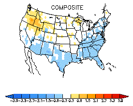
And what do El Ninos typical favor in the Northwest? Warmer than normal temperatures. Here are the typical temperature anomalies (from climatology) for some previous El Ninos... the orange/red colors are above normal
So we have both the warm blob and El Nino working together for warmth.
But what does the National Weather Service's fancy Climate Forecast System (CFS) say? A sophisticated coupled ocean/atmosphere combination that takes everything into account? Here are the air temperature anomalies (right above the surface) for October-November-December. Warm.


And what about the official Climate Prediction Center forecast for this fall? (see below). Not surprisingly warmer than normal.
.gif)
The rest of the winter looks the same.

Is a warm fall and winter guaranteed? Of course, not. But the meteorological dice are heavily weighted in this direction.
Particularly, when these two folks below combine forces.


Please define what "warm" means. Does that mean it will be 70 at Christmas? Or just a few degrees warmer than normal? Using the terms "warm" and "much warmer" doesn't tell us what to expect temp wise.
ReplyDeleteCliff said in this post that the forecast is for 2-4 F warmer.
DeleteThank you Kevin. I didn't see the previous post. Appreciate the response. :)
DeleteMaybe El Niño's name is "Blob". At least, this year.
ReplyDeleteLaura T, one of the maps above shows temperature anomalies for this winter. This shows the predicted difference in temperature from the average between December and February. That map shows A 1-2 degree Celsius increase from the average winter temperature or a 1.8-3.6 degrees Fahrenheit increase. This may not seem like much but to the meteorologist this is a big increase in temp and so they use the term 'much warmer.' It doesn't imply we will have 70 degree temps on Christmas. In fact if you were to just add the predicted rise in temp to the average temp for Christmas Day you would be looking at a high around 48 and a low around 38. Not anything too far from the usual. The main things we may notice as the public is higher snow levels and less opportunities for lowland snow events. Low ski resorts may have to shut down and the snow pack may not be as high as usual, but in terms of just general feel we may not even notice the difference. I hope that answers the question. We won't be looking at a tropical winter, but the warmer temperatures will have some effects on day to day weather events.
ReplyDeleteJack, that makes total sense. Thank you so much for the explanation.
DeleteThe models estimate that it will be 2-4F warmer in December.
ReplyDeleteSource: My eyes; I used them to read the blog post
To the average person 2-4 degrees doesn't equate "warm" and "much warmer". I'm sorry that I didn't understand what was written. No need to be rude.
DeleteOne year down here in Chehalis the first day of summer was 59F, and the first day of winter 60F. I assured our Australian exchange student he should feel at home, warmer on Christmas than on graduation day. He was not impressed.
ReplyDeleteHow strong will the El Nino be? Strong enough to end the CA drought? Strong enough to end the "hiatus" in global warming?
ReplyDeleteAwww, that Blob is so cute. So we've gone through the temperature predictions for the fall/winter (and I like it!) but I haven't seen you say anything yet about likely precipitation.
ReplyDeleteIf I recall correctly, El Nino often means slightly drier here and slightly wetter in California. While I never want to be drier here (in broad terms, we need the water, no matter how much I whine about a particular day's rain), I really hope that California gets a break, enduring a wet winter would be a very good thing for them and for all lovers of grapes, lettuce, etc.
What do you think, Cliff? I could go look at the long-range predictions, but I'm always appreciative of your analysis.
P.S. I'm not a skier, so I don't really care about snow vs. rain, except again to look at the predicted snow pack and the following year's water supply.
:-)
El Blob-o
ReplyDeleteaccording to the Spanish wikipedia page for the film The Blob it's:
ReplyDeleteLa Mancha Voraz
(roughly 'the ravenous spot') so portmanteau:
niñcha
Last time we had that sort of autumn I remember hiking to the top of Hannegan Peak on December 6, with only ankle deep snow.
ReplyDelete80%? That NOAA bar graph you provided looked like it was showing 65% at best?
ReplyDeleteRex Block,
ReplyDeleteI don't think you are correct. First, the pressure or height anomalies have been small during the summer, so what you said can't be true. If you want proof of this go to the ESRL web site and plot the 90 day anomalies.
And although it is true that atmosphere can force the ocean, it is also true the opposite can occur as well. During the summer, when the synoptics are well and synoptic anomalies have been week, the effects of the warm ocean can be substantial.
..cliff mass
We haven't had a good early October "heat" wave for many years...Hot weather in September and warm sunshine (at least for Oregon) mid/late October last year. Is this the year that we see a repeat of 1952/87/91?
ReplyDeleteAlso, I wonder if the "fake cold" inversion problem is going to screw up the temps for the lowlands this winter? Given that warm upper-level high pressure tends to cause inversion during late fall and winter, a really persistent blocky-ridgy pattern could theoretically give a month with below-normal temps for the valleys and basins, coupled with above-average temps for the mountains.
ReplyDeleteWould be interesting if something as crazy as that happened this season. I would hope the payback for all that gloomy inversion would be an early start to spring after Valentine's Day as the higher sun angle began to smash though the inversion.
OK Cliff, so sounds like this Winter is going to be warmer than normal. Is there any way to predict precipitation if we get blob plus El Nino this winter? I would assume split jet stream and dry weather in the PNW correct? Wet in California? I seem to recall that March and April are good ski months in El Nino years. Right after everyone gives up on the season.
ReplyDelete