
For warm weather lovers, today did not disappoint. As shown in a plot of today's high temperatures, many stations in western Washington climbed in the mid-60s, with a number of stations on the western slopes of the Cascades reaching 70F and more.

In Oregon, several locations in the foothills of the Cascades and coastal mountain got into the upper 70s and 80s. Cool foggy air was trapped at the lowest elevations of the Willamette Valley, as illustrated by satellite image at 1 PM below. Temperatures stayed in the upper 40s in that fog.
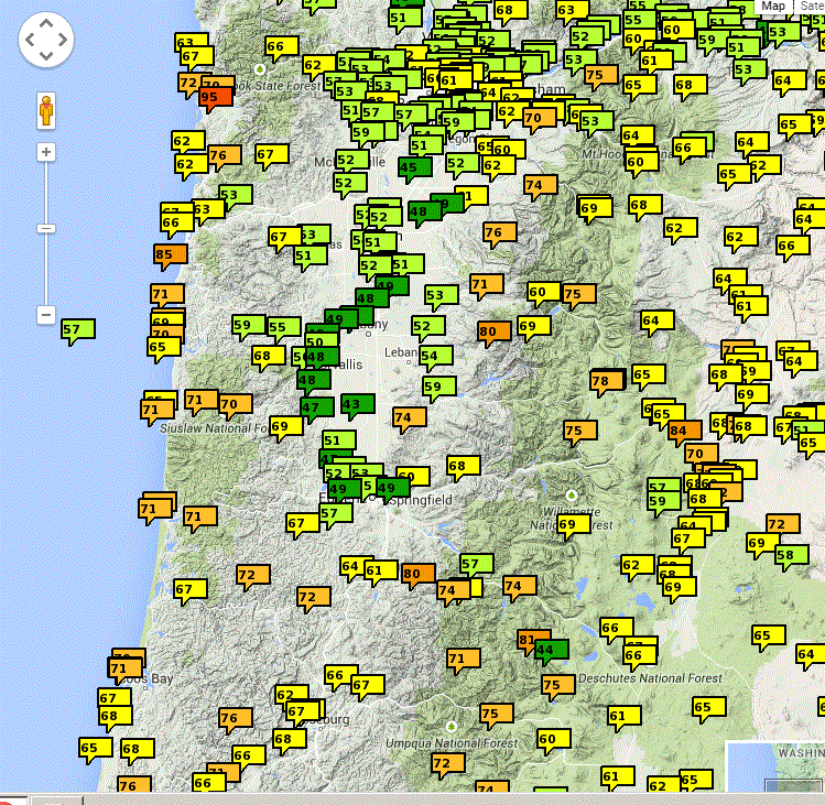

Seattle's high of 63F was the second warmest January day in the entire record. Some of the warmest temperatures were in the mountains and upper slopes. Why?
The reason is clear if we look at a vertical sounding at Salem, Oregon at 4 PM today (red lines in temperature, blue dashed line is dew point). The vertical axis is pressure (700 is roughly 10,000 ft, 850 is about 5000 ft). There was a shallow layer of cool, moist air topped by a very strong inversion,with temperature increasing with height. That is why the warmest locations were found at elevations of a few thousand feet.

Today I was biking along the Cedar River Trail with some friends and I saw something interesting: river fog. Fog that was hanging at low levels right about the river. Here are some pics:


Why such fog? We had warm, relatively moist air and quite cold water in the river (being fed by lots of snow melt!). This warm, moist air was cooled by the cold river water to its dew point...producing fog.
Tomorrow may be even warmer in some places.
In contrast, far colder than normal temperatures are in place over the East Coast, where parts of the Northeast are expecting an historic snowstorm.


Is that 95 flag on the Oregon coast for real?
ReplyDeletewe had an interesting 'river' of fog come towards Port Townsend passing west of Indian Island! Is there a way to post pictures Cliff?
ReplyDeleteAwesomeness. I saw Boeing field record 65. My thermometer at 400 ft. in Shoreline topped at 62.4.
ReplyDeleteI went for short sleeves today, and temporarily ditched the fleece lining. Thanks for the heads up, Cliff!
(I think that 95 flag is faulty....)
At this rate we won't get to go sledding at Paradise this winter at all. 60 degrees??
ReplyDeleteAccording to NOAA, temperatures on the East Coast are about normal. But there is a huge storm brewing.
ReplyDeletehttp://www.cpc.ncep.noaa.gov/products/tanal/temp_analyses.php
Klon...that is not true..look at the latest 30 day anomalies:
ReplyDeletehttp://www.esrl.noaa.gov/psd/map/images/rnl/sfctmpmer_30b.rnl.html
..cliff mass
Cliff,
ReplyDeleteDo those eighties and nineties represent amateur readings improperly taken?
More likely than not March will at least give is some snowpack. I have observed that when the first half of the winter fails, the second half frequently makes up for it. It may make for a short ski season, but I am still betting there will be a snowpack. I just hope it isn't still cold rain in May, and the garden plants aren't too confused by the strange temperature profile.
ReplyDeleteKlon et al,
ReplyDeleteIf you want to see the recent cold anomaly over the eastern U.S. check out:
http://www.cpc.ncep.noaa.gov/products/tanal/mon2day.F.gif
If you would prefer a 90-day mean, check out:
http://www.cpc.ncep.noaa.gov/products/tanal/90day/mean/20150123.90day.mean.F.gif
Related to forecasting: You will surely have interesting comments on the missed blizzard forecasts. Was the European model any better?
ReplyDeletehttp://www.myfoxny.com/story/27950449/missed-call
Cliff,
ReplyDeleteAny chance you could compare the NWS models/predications vs the European model for the "biggest snowstorm of all time" on the East Coast yesterday/today?
Would be interested as NWS came out and admitted their models were "off"/