One important development: Janet Cole of the National Park Service visited the site yesterday. Bill Bacchus, chief scientist of Olympic National Park, sent me this map of the damage, based on Janet's survey of the scene, and the following narrative:
"Most of the trees appeared to be wind thrown, but as you can see from the photos, many were also broken near the base. The amount of trees down was inconsistent, in some areas, nearly every tree is down, but the majority of the area seemed to have lost about 40-60% of standing trees. ... I am attaching an image which shows Janet's rough estimate of the blow down area including arrows showing the direction of most blowdown. Near the drainage outlet, the trees seemed to have fallen southeast, while the western edge trees were oriented more north south. In the eastern edge, the trees were closer to east/west"

And below is a box of similar dimensions to what she drew....with the sides about 1/2 mile long. The prevalent wind direction was from the north-northwest with a tendency to splay out towards the lake.

Another interesting piece of evidence, in fact something quite unique in such weather detection work, is the seismic record at Quinault, something sent me me by Dr. John Vidale, who used to be WA State Seismologist. At 1:26 AM that morning there was a lot of activity...and no tremors were noted at other regional stations. Dr. Vidale suggests that it may represent the tremor produced by huge, falling trees. Fascinating. More evidence for the timing.
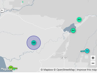
 Now lets examine local weather stations to see if there is any evidence of strong winds or a major weather transition at surface stations. Using the nice weatherunderground.com interface, we turn to the closest station on the south side of the lake, only a few miles away (KWAQUINA2, see map below). The station stopped recording at 2 AM.
No real change in temperature or dew point (top panel, right figure). Wind speeds were quite low (second panel, with blue being sustained winds, dots are gusts). Steady rainfall (blue line in third panel). And the pressure shows a weak downward trend (bottom panel). But look closely. VERY closely. There is a downward spike at 1:25 AM. Something abrupt and short-lived happened. Is this important, or is it a red herring provided by some meteorological Moriarity?
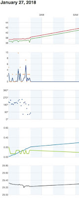

Another station on the map (NE corner), a highly accurate NOAA climatological site, only has temperature and dew point. Here is the plot from that station (MQTCW1). Nothing happening at the time..


Our meteorological Sherlock is perplexed. The trees fell to the south or southeast, implying a very strong northerly wind. None of the surface locations shows strong wind and most of them are easterly or southeasterly. Wrong direction. There is no strong convection or thunderstorms, so no microbursts.
But there had to be something going on around the time of the tree fall...and there was---a frontal zone was approaching, with warm air and southerly flow surging in aloft, while cooler easterly flow dominated near the surface.
The National Weather Service official surface analysis for 1 AM shows the front approaching, and it was associated with a low pressure system that would bring strong winds to western Washington later in the morning.

Could this be important? We get fronts all the time without extreme local blowdowns as occurred on January 27. Sherlock is unsure.
We will investigate this last lead in the next installment.
 _______________________________
Announcement: A very interesting free lecture open to the public
The history of cloud seeding to enhance precipitation, and prospects for the future. Professor Bart Geerts, University of Wyoming

And below is a box of similar dimensions to what she drew....with the sides about 1/2 mile long. The prevalent wind direction was from the north-northwest with a tendency to splay out towards the lake.

No real change in temperature or dew point (top panel, right figure). Wind speeds were quite low (second panel, with blue being sustained winds, dots are gusts). Steady rainfall (blue line in third panel). And the pressure shows a weak downward trend (bottom panel). But look closely. VERY closely. There is a downward spike at 1:25 AM. Something abrupt and short-lived happened. Is this important, or is it a red herring provided by some meteorological Moriarity?
Frustrating....perhaps the Sasquatch or alien visitation explanations should be taken seriously! OK, let's move out a bit.
The station in the terrain to the SE showed nothing interesting, with moderate easterly flow during the period. Wrong direction
And the station to the west-southwest was similarly bland, with southeasterly winds:
Our meteorological Sherlock is perplexed. The trees fell to the south or southeast, implying a very strong northerly wind. None of the surface locations shows strong wind and most of them are easterly or southeasterly. Wrong direction. There is no strong convection or thunderstorms, so no microbursts.
But there had to be something going on around the time of the tree fall...and there was---a frontal zone was approaching, with warm air and southerly flow surging in aloft, while cooler easterly flow dominated near the surface.
The National Weather Service official surface analysis for 1 AM shows the front approaching, and it was associated with a low pressure system that would bring strong winds to western Washington later in the morning.
Could this be important? We get fronts all the time without extreme local blowdowns as occurred on January 27. Sherlock is unsure.
We will investigate this last lead in the next installment.

Announcement: A very interesting free lecture open to the public
The history of cloud seeding to enhance precipitation, and prospects for the future. Professor Bart Geerts, University of Wyoming
February 15th, Kane Hall, University of Washington Campus
For information and to register go here:


Hi Cliff,
ReplyDeletehttp://www2.mmm.ucar.edu/imagearchive/
It looks as if there is some kind of convective feature at this time that just crossed KHQM moving NE?
This line looks to be just SW of the mini-blowdown at 09:30Z
Just looked curious and I thought I would throw that out there...
http://www2.mmm.ucar.edu/imagearchive/
What about our current weather? Where did the La Niña go?
ReplyDeleteI posted the mystery on the PNSN Facebook page.
ReplyDeletehttps://www.facebook.com/groups/thePNSN/permalink/1740839305979277/
We'll see if anyone contributes clues.
The Sasquatch explanations should be taken seriously.
ReplyDeleteMy grandfather believed that it was the UFOs that drop the Sasquatch off to do research on the region then they picked them back up. That's why there's no trace of their remains or are able to track their Footprints. Something to think about...
DeleteI think this event will be a good topic at a future NW Weather Workshop.Perhaps an interesting project for UW Atm Sci grad students?
ReplyDeleteNot the first big blowdown in the area. Compare 2006 and 2009 images in Google Earth along the south shore of the lake just south of the Rain Forest Resort. Big windstorm in December of 2007. But that storm was over a wide area.
ReplyDeleteGiven the lack of climatologic phenomenon supporting wind at the time and the fact that this appears to be in a fan-shaped drainage of a hillside coupled with the incredible amount of rainfall recently saturating the ground, I would guess that it was likely a small landslide that abruptly moved on top of a relatively impervius layer of blue clay. A quick jolt created by the movement that caused the trees to sway, then recoil subsequently snapping them off above the ground, not tipping them over with their root structure. Such "deceleration" events are a well-described event in aortic trauma in car crashes with sudden horizontal deceleration. The "whip" tears the structure at areas of attachment due to variable shear. So my guess is; Meterology, yes; saturated ground but the ultimate event likely a localized geologic phenomenon.
ReplyDeleteThis is what I was thinking as well!
DeleteI think it was likely a small landslide of the top soil in the drainage causing a sudden lurch, then whipping and snap of the trees. Lots of saturated ground. Hillside. and no wind noted.
ReplyDeleteFrom my experience in the 1990 windstorm that struck the eastern San Juan Islands, the winds in this event were probably closer to 100 mph to do that kind of damage. Can't offer any insights into the cause of this. A splendid mystery.
ReplyDeleteWell, I do not have any ideas but enjoying reading about the mystery and how it is being solved!
ReplyDeleteGravity Wind.
ReplyDeleteHaving grown up in that area I would be interested in investigating any ancient tribal writings or passed on stories of similar events. There is a lot of history for the area.
ReplyDeleteBig blowdowns aren't uncommon in the area. South side of the lake, December 2007 along Gatton Creek, also Willaby Creek. That one was apparently a big coastal storm though.
ReplyDeleteI suspect it was a tornado. A similar event occurred in the ONP in 1921..
ReplyDeletehttps://www.fs.usda.gov/Internet/FSE_DOCUMENTS/fseprd493595.pdf
I'm more convinced its a williwaw or any other colloquial term for localized Katabatic winds. Cold dense air descended the drainage from the high saddle on the ridge east of Higley Peak directly above the drainage. Gravity directed flow like water into the drainage, concentrating and intensifying it. This would explain why it was so local, and would also explain why the tree fall pattern splays out where the drainage enters its alluvial plain and is no longer constrained by the topography.
ReplyDeleteThe temperature graph from the KWAQUINA2 does show a sharp downspike roughly half hour after the event (or is that the dewpoint... meteorological graphs are notoriously bad at not containing captions/figure descriptions. Can we do something about that?). Could that temp drop be associated with continued katabatic flow over the ridge on the north side of the lake slowly filling the lake basin and dropping the temperature? That doesnt explain why the decline in temp was so short lived though...
Another colloquial term for katabatic wind in Greenland is "Piteraq" which, apparently, are most intense whenever a low pressure area approaches the coast... But thats a big ice sheet phenomenon.
Given many of the trees were right beside a paved road, and fell over it, yet the road wasn't affected at all (based on the picts), then landslide seems unlikely. This is heavily forested old growth land and not on a steep slope.
ReplyDeleteIt would take one heck of a monster seismic event to snap huge trees off like that, yet only a tiny seismic event was seen of the magnitude that could be explained by falling trees snapped off just above ground level.
Curiouser and curiouser...
Quasi Linear Convective System tornado
ReplyDeleteShock wave from a small asteroid bouncing off the atmosphere or breaking up in the atmosphere... a thought.
ReplyDeleteI still think this has something to do with the lake. The tree fall happened along the shoreline (not higher) but they are falling toward the lake (it would be great if we could get an aerial shot)... so if the williwaw hits the hard surface of the lake, what is the physical change in the wind? Like a waterfall hitting the bottom, could there be a lot of turbulence there?
ReplyDeleteIt was actually much higher than on the shoreline - I live a mile from it
DeleteWhat if it is a small Tunguska-like event?
ReplyDeleteCliff, myself and my co-workers observed a similar situation in the spring and summer of 2011. I believe the actual tree fall occurred in the winter, but am not sure. I can recall at least two areas where narrow swathes of large, old growth firs and hemlocks were felled in thick forest. The swathes were maybe a quarter mile long and 100-200 feet wide. One was along the Cathedral Pass Trail in the Alpine Lakes Wilderness (about one mile up from the trailhead). The other was along the Pacific Crest Trail about a mile north of Snoqualmie Pass. I think there was a third area also, but can't recall where. None of us could figure out what had happened, or how. Never seen anything like it.
ReplyDeleteCliff I grew up in the east and spent a lot of my adult years in the south. The only thing I've ever heard of twisting trees off like that is a tornado.
ReplyDeleteWhy don't you post on what seems to me to be an unprecedented streak (now 3 weeks or so and more to come) of spring weather in the middle of "winter"?
ReplyDeleteThis is devastating for ski resorts and may bode ill for water supplies later.
Water supplies are fine if you check the data and the snowpack info.
Deletemaybe this will shed some light on it...
ReplyDeletehttp://www.peninsuladailynews.com/news/forest-service-approves-special-use-permit-for-navy-electronic-warfare-training/
Wow, so 100’s of trees have mysteriously fallen in the middle of the night, and in the background of all this is the military doing daily warfare tests in the area which, it seems, many local people are against for fear of it damaging the environment and wildlife.
DeleteThanks for sharing, this is fascinating.
This isn't an "unprecedented" streak of spring weather. It's not even close. We have had significantly warmer streaks in the winter (particularly February; at 54 degrees yesterday we were 12 degrees off the record for the date).
ReplyDeleteThis has been a great winter (began mid-November) for ski areas. The last 2 weeks at lower elevations haven't been great but that doesn't make a season. Mt. Baker and Crystal have been fantastic this year. And now next week it is looking like the sun is going to hit the slopes. With 14' of packed snow at the top of Alpental, do you think people won't be enjoying the skiing in the sun?
The water supply here is all but done. Massive amounts of snow at higher elevations (which is the only "snowpack" that matters after June), reservoirs currently dumping water they are so full. Water managers here are going to breathe a sigh of relief next week when the sun comes out. Given the current reservoir height the vast majority of lower elevation (<6k feet) snowpack will go down rivers back to the ocean April - June. Of course that's if it doesn't cool back down in spring. You do know spring meltout dates have been trending later here, not earlier?
http://cliffmass.blogspot.com/2016/05/stevens-pass-melt-out.html
I just read a Cliff Mass paper (2010) looking at spring meltout dates in the Cascades back to 1930. He found that meltout was trending five days earlier over that time period, not later,though the difference was statistically insignificant.
DeleteI can't think of skiing at Crystal as "fabulous" this year, a matter of opinion of course, but they did install a whole lot more snow-making equipment for this season. Quite a few days of operations have been with limited lifts running. Any comparison of opening dates has to be further qualified: Though skiing started in mid-November this year, local areas now open with as little as 16 inches (or less!) on the ground. Back when my spouse and I were involved in area operations (70s-80s), we wanted about 36 inches before opening; we didn't have today's slope grooming capabilities.
Cliff, please give us the heads up on the weather workshop... I might want to go this year.
ReplyDeleteStrong gust induced by avalanche from the ridge above, itself caused by the warm front which also melted the evidence
ReplyDeleteBigfoot on a rampage.
ReplyDeleteThat's the only plausible explanation.
As Sherlock Holmes would say
"When you have eliminated the impossible, whatever remains, however improbable, must be the truth"
I think S S may have an important clue regarding the Navy exercises.
ReplyDeleteA number of years ago, I was hiking with a group in the Cascades just west of the Leavenworth area. We were walking along a long, narrow lake at about 6,000 ft altitude. Suddenly an A-6 jet swooped down into the canyon, flying on its side, and flew along the lake, scaring the bejesus out of us, then righted itself and accelerated up out of the canyon.
If something similar to this occurred, especially at supersonic speed (if possible), the shock wave could have done this.
Is there any observation of such activity in the area at the time?
Late at night, on New Year's Eve, 1995, a narrow blast of wind came straight out of the west and roared through the forests at the northern edge of La Pine, Oregon. It was about a mile wide and knocked down mature lodgepole pines, snapping them off at their bases. Knocked power out for a week. It came through at the lowest point in the area, which was at an elevation of about 4200 feet.
ReplyDeleteBest guess put forward as to what happened was that the wind was the edge of a jet stream touching down. But do they do that?
Also, what was similar to what happened at Lake Quinault, is that it was unusually warm that day in La Pine. It was 60° that afternoon. This country is High Desert and is typically cold. Within a day or two of this, we were into heavy snows.
So we are very interested to hear what Sherlock Mass is going to say about it all!
We walked the fall area this morning. The nature of the damage needs some clarification.
ReplyDeleteFrom Part I: "First, how strong did the winds have to be to do such damage? I spoke to Logan Johnson, Meteorologist in Charge, at the NWS Seattle Office. He suggested that to snap off such big trees would take winds of at least 70-80 mph. Maybe more."
This comment needs some clarification. The majority of the downed trees have root balls attached, they pulled out at the roots. They were clearly very shallow rooted. Also one of the two very large trees that shattered (in the picnic area) was rotted in the center; I could not get close enough to examine the other. In addition, some of the shattered trees were clearly hit by others; others were clearly rotted and weak.
So perhaps we are not talking about quite such high winds.
That still leaves the mystery of how local the damage was.
Rebecca -
ReplyDeleteI agree with you on the changes in technology since the 80's re: opening dates (I probably saw you up there!) but I was responding to a post that said the current conditions would be "devastating for ski resorts" and pointing out the lack of context. Baker did open Heather Meadows with 30"+ in mid November this year - https://www.seattletimes.com/life/outdoors/for-real-crystal-mountain-ski-area-to-open-wednesday-baker-on-thursday/ (Nov 14, 2017)
Cliff updated the 2010 meltout article in 2016 and said this: "...here are the mean melt-out dates for recent decades (again, thanks to Mark Albright). It appears that the melt-out dates are getting progressively later..." and then provided this:
1980s: 30 May
1990s: 1 June
2000s: 2 June
2010s: 4 June (thru 2016)
I actually think the skiing has been above average this year but yes, if we are basing this off of the last 3 weeks, not great!
Walt D, good point. In my area of responsibility in Northern Minnesota, after a couple years of drought and a heavy insect infestation trees went down in 40 mph winds. We stopped using downed trees to verify. Root balls suggests very wet ground, also weakening. Maybe it wasn't the weather at all but circumstances.
ReplyDeleteSo c'mon, Doc, give.
Is it too late to start a betting pool? There are some pretty wild horses in the race!
ReplyDeleteSnowpack has not been the greatest here in OR, with Mount Hood Meadows and others having small bases. However, skiing conditions here have always been a crapshoot, Oregon natives who are avid skiers usually head out to Bend and/or Canada during many winters.
ReplyDeleteOur version of a crop circle? Giggles
ReplyDeleteA comment above said: "Also one of the two very large trees that shattered (in the picnic area) was rotted in the center; I could not get close enough to examine the other. In addition, some of the shattered trees were clearly hit by others; others were clearly rotted and weak."
ReplyDeleteThis is what you will find when trees fall - they are all sick and weak. The underlying reason is that they have been absorbing toxic levels of background ozone pollution for decades.
https://www.youtube.com/watch?v=sn1Xy_j48k0
I haven't heard any mention of the fact that more than 50% of the trees were second growth Hemlocks that uprooted. NPS needs a more extensive survey of the types of trees and method of failer. How many were diseased damaged too. Also, there was over 100 trees downed just across the road. That is not counting the whole area effected. Could be thousands. As someone who worked on the cleanup, there was very few other species than hemlock which have a very shallow root structure and could easily tip in minor, opposing prevailing wind, especially with the amount of ground saturation present. Those Hemlocks provided a lot of collateral damage.
ReplyDeleteThis phenomenon captured my attention because I experienced a similar event in the Bavarian Alps during the mid 80s. During a foehn (Chinook wind?), several isolated stands within a nearly continuous forested area were snapped and thrown. Some buddies and I went to check out one of these areas as it began to calm down (don’t do this at home – wait until completely calm!). It was probably less than a quarter the size of the Quinault event, and the 25ish large conifers seemed to have fallen in a more random orientation.
ReplyDeleteI looked for information about foehn winds in that area of Bavaria and there is fair amount available, some in the public domain. This was written clearly enough for a layman (me) to grasp some key concepts while giving meteorologists enough material to judge its merits (link is 125 page pdf): http://acinn.uibk.ac.at/sites/default/files/Vergeiner_Johannes_2004_Diss.pdf
“South foehn studies and a new foehn classification scheme in the Wipp and Inn valley”
Perhaps embarking on another adventure with a skill set not up to situational demands, I accessed the NEXRAD archive and roughly overlaid some of the Doppler images – doing some scaling in GIMP since the base map I used wasn’t georeferenced. I didn’t check whether the images are unusual for the area, so it is possible what I’m seeing is just noise – my original thought – until I stretched the images to fit the coastline. Using the spectrum width and radial velocity data from the three lowest angle scans 0921-23Z, it sure looks like something was going on.
The radial velocity and spectrum width elevation angle 0.38 at 092223Z show distinct features that are somewhat larger but less distinct in both 0.78 elev angle images. In the 0.12 angle images they are less discernible, but still apparent. Unfortunately I don't see a way to attach photos, so hopefully you'll have a chance to check the NEXRAD II data if you haven't already. Look for a "beak" with the tip generally oriented to the SSE.
Here's an idea: tell me if I'm crazy. We know that extremely dry soil conditions can cause a weakening of the roots. The previous summer was a terrible drought in that area. Could this be a combo of an extremely high force of a wind funnel; combined with weak soil that could have made them topple?
ReplyDeleteThis just in from a friend: Could be the navy playing with a new type of weapon technology. (Yipes.)
ReplyDeleteWas thinking the same thing
ReplyDeleteJanuary 27, 2018 5 large fir trees fell in our yard around 10 AM or so. On the southwest side a valley was opened up by logging which as created 300 x the sustained wind activity. On that Saturday I was upstairs, with the curtains wide open for light, since we had lost power already, the wind when all of a sudden changed direction and came from the east. The house was pelleted with branches and loose debris, I looked up and watched limbs go by at nearly eye level in a two-story home, then in a few seconds, it died down and I was still watching when 5 large fir trees, south-west of the house fell toward us. One took out the shop, the rest laid out in the yard, missing the front porch by a foot or so. We have recent logging activity, high water tables and heavy clay soil. So no brainer, but that wind shift, that I've never experienced before with such intensity. Of course the fall shook the house. We were the only house hit like that in a 2 acre lot community. That snap in direction change was the key, while obviously the trees had become more at risk by loosing their protection.
ReplyDeleteHowdy Cliff, Several years ago I had this one dream about a huge wind event wiped out a bunch of trees. This was around that huge storm we had around 2006. Then I hear about this and whoa I just got my mind blown.
ReplyDeleteHi! We live a little less than a half mile from the start of the incredible blowdown here on the North Shore of Lake Quinault. I woke up about 1:30 am on January 27th and could hear the wind blowing VERY hard. I heard a huge thump, living here on the North Shore for 32 years we have heard lots of huge trees go down in the forest and I knew that was what I had heard. My husband woke up and heard the wind and we both went to the front door and opened it. The wind was blowing so hard then we heard a loud rumbling sound which I thought was thunder. It probably went on for about 2 or 3 minutes. My husband went out on the porch and he could hear lots of trees going down he thought it was a blowdown or a landslide. We had never heard anything like that! Two of our neighbors heard the same rumble. My husband is a weather fanatic, to say the least, and he is always watching the radar and satellite images to see what is going on. He had looked at the radar about 11:00pm and saw some very heavy rain in the area. Before we went to bed he told me that it looked like a major weather event was going to happen from what he was seeing on the radar. We have a National Weather Service meteorologist in our family who my husband consulted with about it. He asked my husband to look to see if the trees had fallen in the same direction or in a spiral pattern. Since most of the trees blew down towards the south he said that it sounded like a micro-burst. This is from someone who in his job (along with assistants) goes to disaster zones that have been caused by tornadoes and other wind events to determine what more than likely happened. He says that at times it is very difficult to make a judgement on what caused a wind event. . the same as our meteorologist relative. Because the lightning did not show up on the radar would not definitely mean that it did not occur especially since 2 other neighbors also heard what they believed was thunder. I know you are making a judgement from what you have seen in photos, read about it and from your knowledge of weather but as you know there are always different opinions based on identical facts. I think you should come see the site and talk to locals and then make your judgement. Thanks for listening!
ReplyDeleteGoogled out of curiosity as we have witnessed a similar tree fall in Pune, India, a week back. A whole bunch of trees have fallen all around the city.
ReplyDeleteYes, we did have rainfall, but nothing abnormal to cause trees all over the city to fall down. This is highly unusual.Trees communicate through their fungal networks and there has to be a reason for such massive fall spread out in different pockets throughout the city!