Let me show you and explain the fascinating and complex situation we are in.

Here is a plot of the particulate levels (PM2.5) at the Puget Sound Clean Air Agency Duwamish site from last Tuesday to 3 PM today (Monday). You can see the rapid surge of smoke yesterday afternoon, followed by a sudden fall in yesterday evening. And then it started rising again this morning, reaching a peak now that is far higher that either yesterday or last week.

In fact, this hourly smoke level is the highest on record at this site (going back roughly two decades) and higher than anything last summer--the plot below is the proof!

Yesterday, as the winds aloft turned northerly and northeasterly, the huge reservoir of smoke in British Columbia and eastern Washington surged southward overhead, but air quality did not decline immediately.
As the surface warmed, the lower atmosphere started to mix, higher and higher, eventually tapping the smoke aloft and bringing it down to the surface. That is what caused the air quality to rapidly degrade.
Last night, the surface cooled, the mixing driven by surface heating dropped off, and the lower atmosphere became stable, with little vertical mixing. So we stopped tapping the smoke aloft. Then relatively clean air moved into central and northern Puget Sound from the Strait of Juan de Fuca, leaving us with better quality air, which was present this AM.
But why did things get so bad this afternoon? For one thing, the surface started to warm, resulting in more mixing of smoke down to the surface. The noon MODIS satellite imagery clearly showed smoke above the region and particularly Puget Sound. Eastern WA looks like something out of Dante's Inferno.
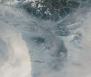
But look really closely. You can see smoke plumes over the eastern slopes of the North Cascades, with the smoke moving toward Puget Sound.
The 3:40 PM satellite image from the NOAA GOES satellite shosw the smoke from these fires crossing the Cascades and reaching Puget Sound. Some domestic smoke. A source of primo smoke aloft.


Wednesday is the transition day, with a onshore, marine push beginning that evening. Thursday, should be a MUCH better day, with clean ocean air over our region.
On a lighter note, the Puget Sound Clean Air Agency gives advice on what you should do in this smoky situation. The only thing advisable is to work on your laptop!


Thank you, Cliff, for this blog and the analysis and explanation of the smoke and other weather phenomena. I learn so much!
ReplyDeleteBellingham is currently swimming in smoke, and appears to be down to ground level.
ReplyDeleteWitnessed a few folks walking around with masks, as passerby's looked on.
A bank on Alabama & James showed 86 degrees at 11:30amish, when I saw 52 this morning @8:00 am with Rich Marriot on Kong.
Went for a short MC ride yesterday (90 miles),
toward the foothills of the N. Cascades, with the smoke and smell down to the surface increasing the father east I went (Maple Falls).
Had a mild headache heading east and north, then dissipated a bit heading back west.
I think lo-energy Whining is sort of the activity of the day! And probably tomorrow.
ReplyDeleteWow! What an apocalyptic day. The Crescent Mtn. Fire generated an impressive pyrocumulus cloud today. The shadow is easily visible even in the MODIS thumbnail image.
ReplyDeleteCliff, can you comment on the 'hazardous' levels shown in parts of western and washington? WAQA says you should evacuate when levels reach the hazardous condition, but I've seen no mention of it in the news.
ReplyDeleteI haven't really seen much talk about true health effects or if any longterm effects exist for being exposed to hazardous levels of smoke/air.
I thought it was odd that only today did the news suggest buying a mask.
We get that it's terrible. How do we stop them? Consensus is that until it snows, we're screwed. Are there ANY new ideas at all? I remember an old John Wayne movie where he put out oil-well fires with explosives that sucked away all the oxygen or something. But seriously, if money we're no object, how could we put out these remote, high altitude fires? Bueller, bueller?
ReplyDeleteClimbed Glacier Peak this weekend. Setting off on Friday and wrapping up today. The smoke on Sunday was bad enough to make you feel nauseated on the way up; definitely not good for anyone's health. Being next to the White Chuck Glacier that recently retreated from a large area and on a volcano with all of the smoke felt very sureal and apocalyptic.
ReplyDeleteFine ash (1/16”-1/8”) falling on South Beacon Hill right now.
ReplyDeleteSurprised to not read more comments about how normal forest fires are in our environment. Fire is a natural part of forests. Forest managers lose crops/trees that they would otherwise sell, but the forest lives on after fire.
ReplyDeleteCliff, can you explain two things please:
ReplyDelete1) Why is there such a preponderance of non-westerly winds? Given the jet-stream and regular weather patters over this part of the continent, isn't this unusual? Weather systems almost always flow west to east in this part of the world, no?
2) I know that wildfires have increased in recent years, but does this explain the extent of smoke, all on its own? That is, I cannot remember smoke really at all for more than a day at a time before last year, and now it pervades for literally an entire month (last August and this August in absolute entirety). My point is that the uptick in wildfires is not as drastic as the uptick of smoke in the area; why is the smoke proportionately worse?
Thanks.
200s in eastern Washington..Chelan was at 406 earlier today and Wenatchee has been consistently well into the 300s. Compared to that, our air is pristine.
ReplyDeleteI'm seeing airquality.weather.gov forecasting surface smoke in North Seattle of between 800-1000 tomorrow morning. Can you explain if this means it will be as bad as it sounds! Extremely hazardous even? for comparison they're saying 76 right now.
ReplyDeleteThank you for this information. Can you explain where the smoke goes once it's "gone"? Thank you
ReplyDeleteI just heard this morning on NPR about a study that shows that summer precipitation is the most important factor in predicting fire risk- and it trumps temperature, forest management, lightning strikes, and winter snow-pack, and that rainfall has decreased 45% since 1979. I was left uncertain about which area they were referring to, however.
ReplyDeleteI also want to mention that many of these fires are burning in remote virgin forest which presumably never had much "management".
Again, cliff, how about some historical records on summer precip over the last 40 years or so?
All the datasets I can find seem to stop around 1990. How does this air quality compare to an average to bad day in pre clean air act major cities? How about industrial revolution England?
ReplyDeleteTo Sam: We obviously didn't have sensors that could measure PM2.5 in the past, not even in the 1960's in the US. The ability to measure the small and dangerous PM2.5 particles is a fairly recent thing, especially in terms of being deployed in lots of locations.
ReplyDeleteOne thing that is clear is that wildfire (wood) smoke isn't the worst contaminant. Coal/coke smoke that blackened everything during the Industrial Revolution (and still does in Beijing in winter) is truly nasty, full of sulfur. Also, the exhausts of automobiles and diesels pre-Clean Air Act was also wildly dangerous and full of not only partially burned hydrocarbons and soot, but also tetraethyl lead, which is truly a horror.
This is small potatoes compared to that.
But the real point, in my mind, is that we mostly cleaned all that up, thanks to government involvement and many people's leadership in the environmental movement. Enough that "small potatoes" events like this freak us out now. That's good. It says we've made tremendous progress.
The trick is not to succumb to current economic and political pressure to slide backwards. One of our new challenges is to figure out how to reduce our current problem of more impactful forest fires.
"I also want to mention that many of these fires are burning in remote virgin forest which presumably never had much "management"."
ReplyDeleteRemote virgin forests had manned fire towers for 60+ years. They had smoke jumpers. They had aerial drops. Putting out fires immediately is exactly the forest "management" we are talking about. All forests in N. America - when it came to fire - were managed this way.
The management has completely reversed. Now, instead of immediately putting out a fire when it starts, forests are actively burned through the use of drip torches, flare pistols, and heli-torches - through to October.
Read about the Wolverine fire in 2015: a fire that started in June - was allowed to smolder through July - then blew up into a massive conflagration in August and September. That would never have happened in the 80's.
Fires - particularly those in remote wilderness - are being actively burned across thousands of miles around us now, and we share their air. That is a fact. If people don't like the smoke then tell the Forest Service and DNR (and Canada) to put them out when they start in the summer, and start burning in the shoulder seasons instead. It won't stop all summer wildfires - but it will certainly begin to mitigate what we are seeing now.
We are paying for the misguided practices of our past, and have now over-reacted the other way. But at least forests are getting back to a more normal cycle. I personally can deal with a week or two of smoke for that.
These fires should cause everyone to get a clue. The solution is long term attention to the causes of climate change and getting government policy at all levels to be informed by intelligent debate instead of the dictated of the oil industry.
ReplyDeleteIs this an accurate source?
ReplyDeletewww.purpleair.com/map#10.19/47.5997/-122.2214
The Purpleair monitors appear accurate for PM 2.5 and 1.0; not for larger PM 10. See, e.g., http://www.aqmd.gov/docs/default-source/aq-spec/field-evaluations/purpleair---field-evaluation.pdf
ReplyDeleteSo, yes, the small particulate data are accurate. And a cool use of crowd sourcing technology!
On Monday I decided to get out of town..Port Townsend..and hiked the Upper Dungeness river trail. There was some haze, but it was Much clearer at 2600'. Driving back home was...gross. Today there are larger particulates dusting every outdoor surface.
ReplyDeleteTo mpulsiv: I've attached the link to a lab test where they compared Purple PA-II sensors it to a GRIMM sensor, which costs about $25,000 and an APS that costs $50,000.
ReplyDeleteThe Purple Air sensors cost $200 to $300 dollars and are designed to upload via your internet (Internet of Things devices) to that Map that you linked to. Essentially, think PWS except they are for particles only.
The conclusion I derived from the report is that the Purple Air sensors are pretty good up to about 250 μg/m3. Above that they increasingly overestimate the particle count, especially PM10.
Given that 0 to 250 for PM2.5 is pretty much the needed range for our area, given it would be unusual for Western WA to get much above 250 unless we had a local fire, I'm planning on buying one.
So yeah, they're pretty decent sensors, and are being deployed in many more places than AirNow, and growing. I hope people are going to buy a lot of these to fill in the holes that AirNow can't cover. Just like having PWS filling holes that NOAA can't cover with their limited sensor locations.
Here's the link: http://www.aqmd.gov/docs/default-source/aq-spec/laboratory-evaluations/purple-air-pa-ii---lab-evaluation.pdf?sfvrsn=4
I appreciate what Sunsnow12 stated. He referred to my Grandpa (Clarence Larsen) as one of the smoke jumpers working with the Forest Service decades ago. Hopefully the analysts with USFS are brainstorming with their Canadian counterparts to reform our current forest management strategy (and somehow they get the necessary Federal support).
ReplyDeleteMy Grandpa loved his work for the Forest Service, and I never got the impression that he felt he was mismanaging the forest by assisting in putting out natural uncontrolled fires as soon as possible. Though I'm sure he would have preferred the wood be used for building, since that was the livelihood for many of his neighbors in places like Forks.
On the UW Doppler radar page it is showing lots of light blue and blue returns. Is that smoke it is picking up?
ReplyDeleteHey Ansel - the Northwest Climate Toolbox is a great resource for looking at historical temperature and precipitation data for a given location:
ReplyDeletehttps://climatetoolbox.org/
Try the 'Climate Tracker' or 'Climate Normals' tool.
I just learned that there's a major hurricane bearing down on Hawaii. Suppose maybe it gets sucked into the westerlies and gets blown over here. I am hoping so... even if it makes an extra-tropical transition, it could deliver enough rain to put a stop to the fires up and down the west coast! If there is one thing I hate it's wildfire smoke!
ReplyDeleteThat hurricane appears to be strengthening, instead of the usual weakening you see when hurricanes approach Hawaii:
ReplyDeletehttps://www.forbes.com/sites/marshallshepherd/2018/08/22/what-experts-are-saying-about-rare-category-5-hurricane-lane-threatening-hawaii/#5c22ebb72fb3
Smoke affecting mosquitoes?
ReplyDeleteSince it has been so smokey we have not been bothered by mosquitoes in the evening.
My wife is a real mosquito magnet but has been out in the evening and not seeing any.
Coincidence or is smoke confusing the little buggers? Al
Dr. Mass, as a retied forest scientist, I anxiously await your next two blogs. In conducting your research for these blogs I hope you will review the forestry experience in the southeastern United States, where advanced forest management has been in practice for many decades. You rarely read of catastrophic forest fires in the southeast despite the fact that large acreages there are forested. Nearly all of these forest lands are privately owned and their management prescriptions include frequent intermediate cuts (thinning) and controlled burning. A good source of information on this subject is Prof. David South at Auburn University.
ReplyDelete