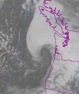
The infrared satellite picture, available 24-h a day, shows that the comma-shaped clouds of the storm are quite high (light shade).
The radar image at 9:48 AM is picking up the offshore circulation, something we could not have seen before the Langley Hill radar was installed near Hoquiam:
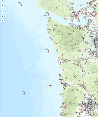
The low center is nearly going over NOAA Buoy 46089, nearly due west of the Columbia bars (see map). The pressure is dropping rapidly there--already down to 980 hPa. This storm is deeper than originally predicted at this time (982-986 hPa). The storm is also moving in faster than forecast by 2-3 hours.
Currently (9AM), winds over the region are not impressive (see plot of winds, wind gusts (red), and pressure). Click to expand. The low is clearly seaward of buoy 46089, where the pressure is 980.1 hPa.
So what about the forecast? The 5 AM WRF prediction for noon shows an elongated, poorly defined low center making landfall on the southern WA coast. Such a distortion works against having the very strongest winds, with the area of large pressure gradient limited to near the Oregon/WA border. But looking at the latest radar loops, I believe this forecast has problems...the storm is staying farther offshore.
The WRF forecast at the time of strongest winds over Puget Sound (about 2 PM PDT) shows sustained winds of 35 knots over Seattle, which would imply 40-55 knot gusts in exposed locations. The low center is just south of Sequim.
But considering the storm's current path, I suspect the winds will be lighter.
There is a modeling system called HRRR that is updated every hour...let see what it shows.
At 11 AM, the low is still offshore...much better.
At 4 PM, the low is over southern Vancouver Island and the pressure gradients are only moderate over Puget Sound. Much more reasonable and implies a much more modest Puget Sound event.
So will it get windy here in Puget Sound? You bet. But I suspect most will only see sustained winds of 20-25 mph with gusts to 35-45 mph. You won't have to wait long to know.
10:50 Addition...the lowest scan angle from the Langley Radar...stunning. Only Langley Hill has this angle (.26 degrees), due to the intervention of Senator Maria Cantwell. You can see the elongated circulation clearly and the fact that this low center is still offshore.
Announcement: Public Talk: Weather Forecasting: From Superstition to Supercomputers
I will be giving a talk on March 16th at 7:30 PM in Kane Hall on the UW campus on the history, science, and technology of weather forecasting as a fundraiser for KPLU. I will give you an insider's view of the amazing story of of weather forecasting's evolution from folk wisdom to a quantitative science using supercomputers. General admission tickets are $25.00, with higher priced reserved seating and VIP tickets (including dinner) available. If you are interested in purchasing tickets, you can sign up here
I will be giving a talk on March 16th at 7:30 PM in Kane Hall on the UW campus on the history, science, and technology of weather forecasting as a fundraiser for KPLU. I will give you an insider's view of the amazing story of of weather forecasting's evolution from folk wisdom to a quantitative science using supercomputers. General admission tickets are $25.00, with higher priced reserved seating and VIP tickets (including dinner) available. If you are interested in purchasing tickets, you can sign up here


The radar picture of the circulation is incredible at noon... a wonderful cyclone. Even better than at 11:00am. A work of art. Can't remember a prettier storm.
ReplyDeleteI put the artwork up on my second monitor so I can enjoy it as I work.
Brovo!
ReplyDeleteThanks for the continuing updates!
ReplyDeleteWe, in the greatly beseiged Northern Interior, thank you.
ReplyDeleteI really appreciate this analysis.
ReplyDeleteHere in East Bellevue at 1:45 pm, we're having sustained 23 mph winds (over 2 minutes) and have had a 36 mph gust with others in the mid-30s. I think you've about nailed it. This is higher sustained speed than we had in our "surprise" storm last week.
Thank Cliff. This is a fun one to watch and better with your analysis. I'm on the north side of the Strait on Southern Vancouver Island. Looks like the low is tracking right at us. Winds are gusty, but I don't think the 50kt forecast from WRF/GFS. Langley radar continues to impress. This storm looks like it has an eye.
ReplyDeleteOn my trail run this morning we got hit with slushy rain at the 1600 foot level. Plenty of cold air around with this one. Looks like the tropical plume is aimed at California who need it more than we do.
Nice to have a good round of storms to provide symmetry with the start to winter and all its fury in December.
In Queen Anne, we've had a gust as high as 55mph, with sustained winds of 35 mph and above. Not a trivial storm, though so far, we've still got power (unlike 35,000+ other City Light customers).
ReplyDeleteCliff, any idea when the winds in Seattle will start to die down?
For those of us aspiring weather nerds, would it be possible to include links to the pages where some of these graphics can be accessed?
ReplyDeleteThis comment has been removed by the author.
ReplyDeleteCliff,
ReplyDeleteYou showed a 9am map of wind speeds across western WA. Is that a live map that can be accessed by anyone? If so, could you post a link.
Thank you!
Cliff: just discovered your place. Interesting stuff, well-explained to this non-weather guy, who enjoys looking out the window at the weather here in Port Ludlow. (Got a great view of the harbor and Sound.) Have a simple WU place (KWAPORTL19) via Accurite stuff - not the best, but almost good enough.)
ReplyDeleteNoticed that you are on BlogSpot....I could help you move things to your own domain name. (This is not a spam mail....just wanting to help.)
Contact me, if you are interested, via the link to my comment. In the meantime, I've put you on my 'daily bookmark' list.
Thanks.
Been pretty strong here in Duvall. Lost power twice (10 seconds first time, 1/2 second second time). Typical erratic wind gusts with a winter storm.
ReplyDeleteBellingham airport just hit 66 mph and Bellingham Bay looks like it's being boiled. This is a pretty impactful storm up in Whatcom Country right now!
ReplyDeleteThe storm picked up here in Bellingham at about 3pm. The Bellingham Cold Storage weather cam is showing SSE sustained winds and gusts in in the mid-50s over the last hour. Exciting! https://www.bellcold.com/about/
ReplyDeleteI guess Marco has a shot after all.
ReplyDeleteAs the storm came through Walla Walla at about 3:15pm we had a minute of kettle drum thunder claps at 5 second intervals. Thye did not roll. Just a series of regular thumps. Never heard thunder like that before. The trailing edge of the storm brought traditional clap and roll thunder.
ReplyDeleteHi Cliff,
ReplyDeleteI always look to you as the "weather expert" in this area but clearly you were very wrong about this storm after dismissing the NOAA forecast as hyperbole. In your blog post you stated ...
"Yes, it will get blustery during the latter afternoon, but we are talking about 30-40 mph gusts, NOT the 60-70 mph gusts being advertised. Thus, we are talking about a relatively tame event."
This was clearly incorrect on many levels. I took your forecast and headed outside to the UW campus where I was stranded from my home on the east side as the 520 bridge was closed for the first time since 2014 after structural damage and high winds. There were many left without power, 405 closed due to downed trees and a person killed by a falling tree, hardly the "tame event" that you stated to the general public.
What went wrong Cliff? Was this a lack of data issue? A problem with the models? Why did NOAA Meteorologists interpret the same data so differently and **accurately** predict the storm as expected?
Dixon,
ReplyDeletePlease reread my blog. I said that most folks would only see 35-45 mph gusts and that is exactly what happened. Some locations near the water and in exposed locations had some stronger gusts. My point was that there was substantial uncertainty in the forecasts and than many of the model runs showed a weaker storm. The storm ended up different than forecast.....much earlier, strong, and better structured...and happened to follow the ideal route for strong PS winds. I was trying to communicate the uncertainty of the forecast, which is something the NWS and others often do not provide.. Forecasts are really probabilistic exercises....cliff
Interesting article. Check this out
ReplyDelete