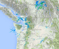
First, today's weather. The 8:20 AM radar shows a few showers over Northwest Washington and along the western slopes of the Cascades. Scattered light showers elsewhere.
The visible satellite image at 8 AM shows extensive low clouds over the eastern Pacific and western Washington and Oregon. Classic situation with cool marine air enveloping the region west of the Cascade crest.
The latest forecasts suggest a cool day, with extensive cloudiness breaking up into partly cloudy skies away from terrain. Here is the UW WRF model precipitation forecast for the three hours ending 11 PM tonight (fireworks time). A few scattered sprinkles, particularly on the Cascade western slopes.
The weather.com forecast for fireworks time (see below) suggests temperature around 60F with about 15-20% chance of precipitation. Bring a sweater.
But marginal July 4ths are a tradition in western WA, and usually this is a rapid improvement in the following week.
Not this year.
Here is the forecast upper level chart (500 hPa) for next Saturday morning. A HUGE low pressure centered east of Vancouver Island. The jet stream (where the lines are close together) is strong and heading south into Oregon and northern CA. What season is this?
The latest Climate Prediction Center 6-10 day forecast for temperature and precipitation is enough for you to put away the shorts and pull out the sweaters. Blue cold in the west, while the eastern US is warming
Precipitation? Wetter than normal over us.
But the next 72h is amazing, with several inches in the Cascades.
The new normal has switched to the old normal.


So far, this looks like a replica of the summer of 1983 when I moved back to Portland after an 18 year absence. Temperature hit 100 on Memorial Day and was still in the 80s the first week of June. The day I arrived, June 9, was the last hot day until mid-August. It was a green tomato summer for sure.
ReplyDeleteEvery year is different it seems. Last year it was 90s and 100s in the PACNW, this year 60s and 70s and rain and wind in places. I enjoy summer weather, but it is refreshing to get a break for a bit until more heat comes in. I mean 2014 and 2015 were so hot, and this spring was so hot, so a little moderation is welcome.
ReplyDeleteCliff, I have read some other reports that the BLOB is not dead but still around, just in weaker form. Is this true? I personally couldn't tell from those NOAA graphs showing SSTs for the whole Pacific Ocean.
Ah, yes, just like it was several years ago: cool and cloudy. Though unlike in past years the furnace did not kick on.
ReplyDeleteSure was humid today!
ReplyDeleteLots of summer left.Things can change pretty fast.I remember past years that had cool and wet June's and early July's that turned out hot and dry for late July and August and even into September. Some years that immediately come to mind are 1990,1993,2005,and 2012. Some summers had hot and dry starts with rainy weather in August like 1991,2004,2008,and 2015.Even in 2010, 2013 and 2014 we had wet Septembers after pretty nice summers. Than there were the summers that never really got going like 1999,2001,and 2011.
ReplyDeleteThe fireworks turned out fine in Bellevue, no rain during at all. Not sure if it was raining at the Seattle event, but the Bellevue one was great weather, and an amazing show.
ReplyDelete