Where should you head? British Columbia's Strait of Georgia.
Zooming in closer, one sees the coastal upwelling and the warmer offshore. But if you look even closer (in the NE corner) was will notice some warmer water (yellows and even oranges) in the Strait of Georgia, between Vancouver Island and the BC mainland.
Let's move ever closer. Cold in the Strait of Juan de Fuca, but into the mid-60sF within the central Strait of Georgia. Warmer than Los Angeles!
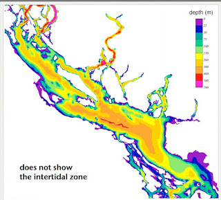
So why is the Strait of Georgia so warm? The topographic map of the region (below) and the depth of waters of the Strait of Georgia (also shown) give some hints. The inner Strait of Georgia is isolated from the ocean and has weak tidal currents. Furthermore, there are substantial areas where the water is shallow.
Quite suitable for swimming without a wet suit!
Talk in Port Angeles on Wed. August 17th
I will be talking in Port Angeles about the Future of the Pacific Northwest Under Global Warming at 6:30 PM on August 17th. More information here.


Pendrell sound is here, on East Redonda Island: https://www.google.com/maps/place/50%C2%B016'29.1%22N+124%C2%B042'50.5%22W/@50.2205164,-124.8028356,11.5z/data=!4m5!3m4!1s0x0:0x0!8m2!3d50.27474!4d-124.714035
ReplyDeleteThe water temp there was 70F there 2 weeks ago. We've seen it 85F in Squirrel Cove. It's the Mediterranean of the PNW (for 2 months of the year anyway).
Eric
I'd like to see the water temps around Port Susan/Warm Beach. When the tide is in, it's like bath water on Camano Island.
ReplyDeleteWhen the water is at high tide at Centennial Beach in Delta on a warm summer day I wouldn't be surprised if the water temperature was in the 80's as well. The one time I was there the water felt almost tropical.
ReplyDeletehttps://www.google.ca/maps/search/centennial+beach/@49.0180345,-123.047783,1590m/data=!3m1!1e3?hl=en
Someone who lives on Cortes Island related:
ReplyDeleteNot mentioned in the article is that the “tidal divide”, where water that moves around the north and south ends of Vancouver Island meets, is near the south end of Cortes Island, so the water doesn’t move much and heats up – I think this is one of the most important factors.
Some areas in the south Puget Sound get very warm in the summer as well. It's been years since I've swum there, but I remember the water at Kopachuck State Park being well into the seventies in August. Apparently the tides circulate the water over extensive shallow areas that warm it in the sun, plus circulation with the open ocean decreases as you get further south.
ReplyDeleteQuestion the "weak tidal currents" in Cliff's interesting note. Some of those places have the speediest currents in the world. Viz., Seymour Narrows. Or the Mouth of the Sechelt Inlet. 2 knots of current is common. Now, whether there's much mixing, I don't know. Perhaps it's like water sloshing around in a bathtub. But not weak.
ReplyDeleteSo the Pacific NW is cold, and SW Canada is warm.
ReplyDeleteWhen we had our boat, we sometimes stopped off in the Desolation Sound (Marine Park) area in August. As others have mentioned, the limited tidal mixing there creates some very warm late summer water. We stopped going because of all the other noisy Vancouver boats that were there, with the water full of swimmers. But that's one of the prettiest areas between Seattle and Juneau, Ak in June and September when the boat population is low. But it would take a brave and hardy person to go there in the off-season.
ReplyDeleteFor all its beauty and warm water and calm weather in summer, it was named Desolation by Captain Vancouver's men in the 1790's because they arrived "off-season" and found it to be the most inhospitable and desolate place they'd ever seen. Of course, their definition of "desolate" referred to the fact that they couldn't imagine farming the area, or doing anything else to earn a living. Like nearly everyone of their time, their appreciation of natural beauty was limited to finding places where people would actually live, and make a living. That was their job. To find such places. Even the salmon avoid the warm water.
Thankfully, for all the reasons they hated it, Desolation Sound remains mostly desolate, beautiful and empty today, other than during July and August when it fills up with boats. There are no roads that lead to that area, which is pretty awesome.
Yes, I sailed to Desolation Sound in August 2014. It is very beautiful and swim-able, though the water was green with algae and full of jellyfish (not the stinging kind, fortunately). It wasn't any more crowded than Puget Sound, mostly, though the winds were light.
ReplyDeleteBut it takes two weeks, starting from Seattle, to do the trip properly in a sailboat.
@Jeff McClean, there are locally high currents, especially at the fjords, within the basin, but there is relatively low exchange with the outside Pacific.
ReplyDeleteI wrote an article for the Seattle Times magazine section in 1997 entitled, "Where to Swim in Puget Sound" that included a map of sea surface temperature contours from the hydrographic database maintained for the Puget Sound Partnership by the Department of Ecology. The contours were based on all available data from the month of August and "swimmable" water was defined as that above 65F. The warmest water was consistently in Lynch Cove (Hood Canal), which averaged about 72F. Other warm spots were in South Puget Sound and certainly on the landward side of Camano. The computer-generated map was similar to the one Cliff shows, although a staff artist re-did it as a beautiful water color print. - Skip Albertson
ReplyDelete