Take a look at the visible satellite picture at 1 PM today (Sunday). You see the beautiful hooked shaped cloud just off the southern WA coast? That's it. Stunning.
The radar image at 1:28 PM from the Langley Hill radar was amazing...it looks like a tiny cyclone with a beautiful inner vortex, which is associated with a low pressure center. Precipitation intensity was enough with this vortex to drive the snow level to the surface along the coast.
While at the University of Washington wind gusted to 27 knots.
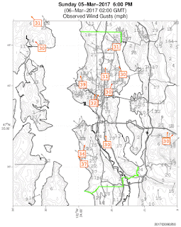
At 6 PM, a number of locations observed 30-40 mph gusts, and winds were strong enough at Seattle Tacoma Airport (40 mph gust) to result in 1-h delays for arriving planes.
The mini-vortex was embedded in an area of unstable, convective showers, which in turn were associated with a larger upper-level trough moving across our region.


It was beautiful. I saw it hit the coast at Tokeland on the radar and watched in all the way in. The front was awesome when it arrived, clocked a max gust of 17mph here in Auburn (although likely closer to 25mph due to obstructions around my wind gauge).
ReplyDeleteI don't remember seeing such a pretty storm on radar in this are before, or at least not for a really long time.
We landed at Sea-Tac at 5:25 pm Subday and we were seriously rocking and rolling as we came in. It was crazy!
ReplyDelete