April 29, 2017

A Spatial View of a Wet Winter

This has been an amazingly wet winter-- but where has it been most unusual?   To gain insights into this important question, here is an analysis from the Western Regional Climate Center (WRCC) showing the percent of normal for October 2016-March 2017 precipitation over the western U.S.  The darkest greens indicate the wettest on record.  A huge region region stretching from northern CA through northern Nevada, into Idaho,  Wyoming, Montana and eastern WA.  Nearly the entire Northwest U.S. was in top 10% wet season.  The April version will add parts of western WA.


The late winter (Feb-March) maps shows how wet conditions were particularly unusual in the northern Rockies.  Eastern Washington, Idaho, and western Montana had unprecedented large amounts of precipitation.

Mean temperatures from October through March?  Cooler than normal over Washington and Oregon....no big surprise.


This week, a colleague at the US Army Corps of Engineers told me that the soils of our region are extraordinarily saturated....and that he was worried about spring flooding.   Well, here is the latest soil moisture observations based on the GRACE satellite (measures moisture using its effects of gravity). The entire Northwest is WAY wetter than normal (darker blue colors).


A front is now approaching our region and there will be rain later this afternoon, tonight and early Sunday morning (see forecast precipitation for the 3 hr ending 8 PM tonight).  So get out now.


Fortunately, the latest forecasts suggest drying from mid-Sunday through the middle of next week, and the latest NOAA Climate Prediction Center forecast indicates drier than normal conditions for much of the West Coast for the 6-10 day forecasts (see below).  Time for me to try planting grass seeds again...


April 27, 2017

Strong Spring Convergence Zone Demonstrates Improvements in Numerical Weather Predicton

The most important western Washington weather feature is probably the Puget Sound convergence zone, a band of clouds and precipitation that stretches roughly east-west across northern Puget Sound and into the Cascades (see schematic)


Puget Sound Convergence Zones typically occur when the low-level  winds on the coast are from the west to northwest, peel around the Olympics, and then converge over Puget Sound.  The converging air streams cause upward motion, and thus clouds and precipitation.  Spring is the big season for convergence zones:  westerly winds are more frequent than any other time of the year and the air is often unstable, which gives lots of clouds/rain when the air is given an upward nudge.

Such conditions were evident yesterday (Wednesday).  A satellite image around noon showed the telltale signs of a convergence zone with a band of clouds across the north sound and clear zones to the north and south.  Why clear?  Due to sinking on the Olympics mountains and the mountains of Vancouver Island.


The convergence zone held into the early evening, as suggested by the Camano Island radar image at 7:30 PM.   Wow...that is a nice band of precipitation north of Seattle!

Convergence zones typically drop modest to heavy precipitation from north Seattle to Everett, and this one was no different.   To illustrate, here is the 24-h precipitation ending 5 AM Friday morning.  A few hundredths of an inch over south Seattle, a half inch north of the ship canal, and roughly an inch over Snohomish county.  Even more around Monroe and the Cascade foothills.


A radar-derived 24-h precipitation total from Seattle RAINWATCH suggests a similar picture.
When the convergence zone moves southward, the weather changes  as it crosses a location are dramatic.  Around noon, the convergence line passed the UW, resulting in an abrupt wind shift (southerly to northerly), a few tenths of an inch of rain, a jump in relative humidity from 60 to over 90%, the loss of most of the sun's radiation, and a roughly five degree temperature drop (see below).
Now let me show you how good high resolution numerical weather prediction of the convergence zone has become.

For example, here is the 27-h forecast of the 3 hr precipitation ending at 8 PM Wednesday from the high-resolution (1.3 km grid spacing) UW WRF model forecast started on 5 PM Tuesday....very nice convergence zone.

Or the 24 hr total ending 5 AM Friday from the same run.   Looks good, with heavier precipitation north of Seattle and dry zones to the north and south.  An expanded view over Puget Sound is also shown.


A decade ago we couldn't make such skillful forecasts, but today it is not an outlier.   It represents the impacts of better data and use of data over the Pacific Ocean, higher resolution models, better model physics, and much more.

The Puget Sound Convergence Zone got me interested in NW weather and I still find it fascinating.

April 25, 2017

Darth Vapor Strikes Again (And Again)

The ominous music rises...in a galaxy far, far away... a band of unnatural moisture strikes incessantly on a sodden land ...

The satellite-observed water vapor imagery tonight highlights the menace, unimaginably wide and extending across the largest ocean basin of the planet. Its tentacles spread so wide that is covers the entire west coast of the U.S. Extraordinary for April.


An infrared satellite imagery at the same time shows a disturbing form, something out of horror/sci-fi films.


And a strange ship has just docked in Elliot Bay.


But this is a scientific blog, so let's consider the facts. During the past week, as much as five inches has fallen on the windward side of the coastal mountains from northern CA to the Olympics, with similar amounts over the Oregon/southern WA Cascades.


And it is not over.  The forecast for the 72hr total precipitation ending Friday AM shows as much as 2-5 inches in the Cascades.


The dark side of the atmosphere has produced, well, dark skies, as illustrated by the Space Needle cam later this afternoon.  No sun glasses needed.


And as noted in my previous blog, we are experiencing the wettest October 1- April 30th in the history of Seattle, as depressingly shown in this figure of cumulative precipitation at Sea-Tac for the water year (starting October 1).  The dark green show the amount above normal (44.69 inches total so far).  At this point in time, we should have 30 inches.


Did you know that the West Coast has been so wet, that San Francisco had more than Seattle's normal precipitation this water year?  Unbelievable but true. 
Here is the proof, with a cumulative precipitation chart for San Fran--more than 30 inches so far. 


No wonder the SF imports in our high-tech industries haven't run back to the Bay area...it has been savage even there.

Darth Vapor will hold its grip on us for a few more days...


April 23, 2017

Pacific Mega Moisture Plume Approaches the West Coast

Major Update:  As of last night, Seattle now has exceeded the ALL TIME record for October 1 to April 30 precipitation. The amount so far?  44.67 inches.
__________________________

It is the JAWS of Pacific moisture plumes.  And it is now reaching our shores.

Today's satellite imagery is stunning... a wide plume of moisture stretching across the entire Pacific Ocean and headed for the Pacific Northwest.  Let me show you.

First, a visible satellite image --what you would see from space--showing a continuous band of clouds, 1000 miles wide, stretching from the western Pacific to just off our coast. Scary.


Next, an infrared image, which shows the temperature of the clouds (or surface), with white indicating high/cold clouds.  Similar thing.


Or an image from the water vapor channel, showing the emission of radiation from water vapor.  Even more impressive, with clear evidence that some of the water vapor plume has reached our coast.


We can also measure wave vapor using the microwave part of the spectrum, and here is a global viewpoint from that wavelength.  The moisture plume  (at midnight Sunday/Monday) can be traced all the way back to the northern Philippines, 6600 miles away!  Moisture from the subtropics and tropics is coming to us!

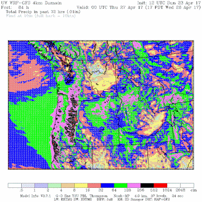
As I noted in my previous blog, this is a relatively unusual situation for late April and ground zero for landfall of this moisture will be the Oregon coast. As it rises over NW terrain, substantial precipitation will be observed.  For example, the 72h total precipitation ending at 5 PM Wednesday, brings 2-5 inches over the Oregon Cascades and the coastal mountains.  Importantly, northern CA gets heavy precipitation, which is quite rare in late April.

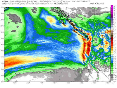
The latest European Center forecast for total precipitation through Thursday AM shows a very wet Pacific Northwest.

You really want to get depressed?  Here is a count of the number of days with precipitation over the past 30 days.  Western Washington is a sunless disaster area.

The complaints about this winter's clouds and rain have been deafening;  perhaps it was contribute to large migration back to California and relieve the housing situation in the Puget Sound region.   I was wondering why traffic has been greater southbound on I5...perhaps our weather is coming to our rescue, sending the high-tech hordes back to the sun-drenched Bay area.


_______________________


How will Northwest Weather Change Under Global Warming?  Help Us Determine the Local Impacts of Climate Change

Society needs to know the regional impacts of climate change and several of us at the UW are trying to provide this information with state-of-the-art high resolution climate modeling.  With Federal funding unavailable, we are experimenting with a community funding to build this effort.  If you want more information or are interested in helping, please go here.  The full link is: https://uw.useed.net/projects/822/home    All contributions to the UW are tax deductible.

April 22, 2017

A Late April Precipitation Pattern I Have Never Seen Before

The model precipitation forecasts for the next few days is extraordinarily unusual for late April, with some aspects unique for any time of the year.

We are talking about an amazingly long and wide precipitation/moisture band coming from the west that will bring record amounts to some locations from northern CA to southern WA.

Let me show you what I mean and be prepared to be impressed.   I will start with the 24h precipitation ending 4 AM Monday from the UW WRF model (relatively coarse outer domain).  I have never seen anything like this:  a very wide band of precipitation stretching thousands of miles due east into the Pacific.  The width of the precipitation band is extremely unusual (very wide).

 Next, zooming in to the higher-resolution (12-km) domain for the 24h precipitation ending 5 PM Monday, one views a very wide precipitation band that is enhanced as it is forced to rise by the terrain in western Oregon and northern CA (1.28-2.56 inches indicated by the pink colors).  I have been looking at these model runs for decades and have never seen anything like it.

Or how about the cumulative precipitation through Tuesday at 5 PM from the vaunted European Center model?  The huge precipitation band is shown, with 2-3 inches from the Olympics to northern California.   Want dry conditions?  Head to the Columbia Basin.

To get an idea of how unusual this amount is, here is the % of normal for the above precipitation totals.  Some locations are 400% of normal.  But it is the north-south extend of the precipitation that really impresses me.

The moisture coming into the Northwest is from a zonal (east-west) atmospheric river.   During the winter, the most significant atmospheric rivers come from the southwest, but they tend to become more east-west during spring.  One measure of an atmospheric river is the vertically integrated water vapor graphic, that shows the total moisture in a vertical moisture in a vertical column of air.   The WRF forecast for 11 PM Sunday shows the high values (blue and reds) heading right towards the CA/OR border.
A forecast of atmospheric water vapor for 8 AM Monday shows the extraordinary east-west extend of the the water vapor plume, which originates over the southwest North Pacific.

You can see the ejection of the moisture from the tropics into the midlatitudes in this animation, which show the distribution of water vapor during the past few days (click on image if it doesn't animate).  So the substantial rainfall we will be experiencing can be traced back, in part, from moisture starting over the Philippines.

The depressing fact:  here in the Pacific Northwest we are living through a record-breaking wet winter and spring, and the action is not over yet.   The good news:  we should transition to an El Nino next winter, which should be associated with a different, and drier, atmospheric circulation.


_______________________

How will Northwest Weather Change Under Global Warming?  Help Us Determine the Local Impacts of Climate Change

Society needs to know the regional impacts of climate change and several of us at the UW are trying to provide this information with state-of-the-art high resolution climate modeling.  With Federal funding unavailable, we are experimenting with a community funding to build this effort.  If you want more information or are interested in helping, please go here.  The full link is: https://uw.useed.net/projects/822/home    All contributions to the UW are tax deductible.

April 21, 2017

Why the March for Science is a Bad Idea

On Saturday, thousands of people around the country will take part in a March for Science.  There will be a lot of well-meaning folks participating, most of them concerned about the activities and intent of the current administration.

But for reasons I will outline below, I believe they will be harming science more than helping.  They will feel better for sure, but they will do little to advance the cause they care about, and possibly do long-term harm.
There are many reasons why the Science March such a bad idea.

(1)  The Science March is overly political and endangers the relationship between science and society.

Science play a critical role in civic life, acting as non-political source of information about the the natural environment and as the generator of useful technologies.  Scientists are credible only when their information is considered unbiased and not politically motivated.   The lack of political bias is why both sides of the aisle have supported the nation's large scientific establishment over many years.

The Science March is clearly political and is an attempt to put pressure on the Trump administration.  It will be seen as political by everyone and particularly those it means to pressure.    Furthermore, the major concern driving this march is not science in general, but of the Trump administration's appointments and future actions regarding climate science and fossil fuel regulations.

(2)  The Science March Makes Science a Target

The march will identify supporters of science as being against the Trump administration, putting a big target on the back of the U.S. science establishment.
I have just finished reading my third book on Donald Trump.   One thing is clear: he tends to act very aggressively against those who cross him, and particularly those that attack his public image.  Do science supporters really want to provoke him unnecessarily and to little advantage?

Furthermore, there is no reason to think that Donald Trump is anti-science in general or that he really has any strong feelings about science.   His anti-climate rhetoric might be similar to his pro-Russian talk: something that might rapidly alter as circumstances change. Do science supporters really want to push him into a corner?

(3)  Republicans are Not Anti-Science and Can Protect Most Science If They Are Given a Chance.

Science research has generally done well when Republicans have been in control.  For example, climate research funding went up substantially during the last Bush administration.  Recently, the Weather Research and Forecasting Innovation Act passed the Republican-controlled Senate and House with overwhelming support.  I have talked to a number of Republican staffers on critical House committees who told me that since they control the "purse" they could protect most of the science establishment.
Climate research is only a small part of the Federal scientific portfolio.  Having questions about climate issues does not make one generally anti-science.

(4)   The March will Fuel Partisanship and Polarization in the Nation

A key problem in the nation has been the polarization of the population and Congress.  The moderate center of the country has been severely weakened, and a cultural divide has developed between the liberal coasts and the conservative interior.  Between haves and have nots.  Will a large protest march for science help bridge this divide?   Or will it identify scientists with other, generally left-leaning, protest groups?  Will those hurting economically that voted for Trump be more likely to support science after a protest? I suspect not.

This is not going to win over Trump supporters

(5)   We Really Don't Know What the Current Congress Will Do Regarding Science Budgets

Congress has not passed a budget yet, so there is little information about what cut-backs or rebudgeting will occur.  Why protest without knowing whether there will be significant reductions and in what areas?

(6)  The March Does Not Have Clear, Explicit Goals.

Go to the the March on Science website. Try to figure out what they are marching to change.  According to their website the March is a "first step of a global movement to defend the vital role science plays in our health, safety, economies, and governments."   Who is trying to reduce this "vital role?"   What actions exactly are being called for?

(7)  The March Organizers Will Not Control the Message

Overtly political or damaging messaging could easily be presented during the march.  What is to going to stop anti administration signage?   What happens if violent or disruptive protestors join the marches?


(8)  There Weren't Marches When Democratic Administrations Distorted Science and Particularly Climate Science

The political nature of this march is highlighted by the fact that there was no call for protecting science  or marches when Democratic administrations played fast and loose with science.   A good example was the sensational and unsupportable claims of the Obama administration science adviser (John Holdren) that eastern U.S. cold waves were caused by global warming.   Demonstrably wrong, but few protested this obvious distortion and politicization of science.  Or the claims by NY Govenor Cuomo that Hurricane Sandy was the result of climate change.  Both political parties have distorted or miscommunicated science when it was in their political interests.


A Better Approach

Instead of marching and being seen as opponents of the current administration, scientists and their supporters would be far more effective if they greatly increased their outreach to the community, communicating both the process and results of science.


Scientists should go into the community and talk about their science.  Speak at local libraries, in schools, and fraternal organizations.   Folks are extraordinarily interested in what we (scientists) have to say.  Make an effort to connect with political leaders.  Use social media (like blogs!). Nothing is more powerful than person to person contact.   Help increase science literacy.  In the long term, public understanding of science and the motivations of scientists is the most powerful tool for protecting the  health of the nation's science enterprise.

Worried that some folks feel climate change is a hoax?  A good reason to have climate scientists enhance active outreach into communities doubting the science.

I won't be out marching on Saturday, but I will continue my science outreach using this blog, my radio show on KNKX, and talks at local groups.   And yes, by continuing do my science, including the determination of the regional impacts of global warming.

Let me end, by saying that there is nothing wrong with marches against the current administration or the current Republican leadership in Congress. But don't involve science in it.  If folks are honest, they would admit that this is basically a political protest against the current leadership in DC. Perhaps the most problematic leadership in the history of our country.   So have a march, but don't use science as a cover, and don't put science at risk.  

Marches like this don't build bridges.   And in a highly polarized society, bridges are desperately needed.   Several of us have built bridges in the area of weather prediction, and this week the Weather Forecast and Research Innovation Bill was signed into law.  Let's build bridges in the area of climate change.  It can be done if we have the wisdom and patience to do so.


Another Northwest Bomb Cyclone with Localized Strong Winds

  Don't tell the media folks, but another midlatitude cyclone will be "bombing" off our coast today, with some local impacts. ...