

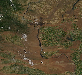
Yesterday's high resolution MODIS satellite imagery shows the smoke from the fire, which was mainly heading southeast towards Moses Lake.

You can actually see the burnt area from space. Here are two images, one from earlier this week and one today. The blackened area resulted from the fire.

Meteorology had a lot to do with the fire....in fact, it was a classic set up. We started with the building of high pressure over the region earlier this week that caused temperatures to surge and humidities to plummet. Here are the temperatures over the past two weeks at Wenatchee. Temperatures warmed towards a peak on Monday into the mid-90s. And there was no rain during that period.

So there was considerable drying.
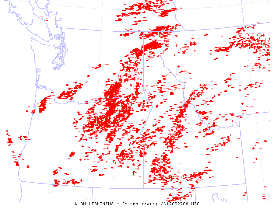
Then there was an initiator of fire: lightning on Monday night as an upper level trough pushed through (see 500 hPa--around 18,000 ft--weather map at 8 PM)

Take a look at the lightning strike map for the 24 hr ending Tuesday at 1 AM. You can see the band of lightning, associated with some modest thunderstorms, that ignited some of the grass around Wenatchee. And started the other fires as well.

You can appreciate the wind acceleration on the eastern Cascade slopes by looking at the sustained winds and gusts at Ellensburg (see below). Big acceleration on the 27th than extended to mid-day today.


Such winds can really stoke a fire and cause it to rapidly spread.
And there is one more thing. A bumper crop of dried cheatgrass, also known as grassoline. Cheat grass is a non-native, invasive grass that has taken over the sagelands of much of the west. It grows prolifically and crowds out the native grasses, which tend to grow in isolated "clumps". Cheatgrass not only grows well, it tends to brown out much earlier than native grasses and is highly flammable.

The spread of cheatgrass has made wildfires more severe in eastern WA, irrespective of global warming. Similarly, poor forest practices and fire suppression on the eastern slopes of the Cascades has made forest fires far worse.
So we had hot, dry conditions, lightning to initiate the fire, strong winds to stoke it, and an ample and highly flammable fuel supply. All the ingredients for major grass fires.
And a message for this weekend.... folks should avoid playing with fireworks east of the Cascade crest, since the potential for major grass fires is in place.


Cliff, have you been following the articles about the Eclipse, and the potential for trouble should it be overcast on the Coast and in the Willamette Valley - and suddenly a million people rushing to east of the Cascades to view it? Combine that with campers, careless smokers, roads all being gridlocked and emergency vehicles not getting through and it could be something. I am hoping that it is clear in the Willamette Valley and am planning to leave from my motel room (along with a party of paleontologists from Japan and elsewhere) sometime after midnight - 3AM to get to our viewing spot. And hopefully avoid the traffic rush.Are you planning to see it?
ReplyDeleteHi Cliff I am wondering where you got the high resolution satellite pictures thanks
ReplyDeleteLots of fine fuels getting dry out there.
ReplyDeleteNice Post
ReplyDeleteDave, the detailed color images are from the MODIS instrument on the Terra and Aqua satellites. Terra passes overhead in the morning, and Aqua in the afternoon.
ReplyDeleteThe NASA Worldview website https://worldview.earthdata.nasa.gov has the easiest access to current imagery.
The Pacific NW is covered by smaller imagery subsets https://earthdata.nasa.gov/earth-observation-data/near-real-time/rapid-response/modis-subsets that may be quicker and easier to view. You can easily download full-resolution images. Look for the HJ Andrews and Saturn Island subsets.
Another neat image resource is from DISCOVR: Epic at https://epic.gsfc.nasa.gov which provides real-time imagery of Earth's entire sunlit hemisphere. Resolution is low at only 24km/pixel.