
Picture courtesy of Nancy Flowers
Picture courtesy of Dyana Stevens

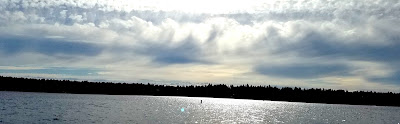
Seattle PanoCam 6PM
What was going on? Yesterday, a weak front was approaching and this feature was associated with an upper level trough coming off the Pacific (see 500 hPa--around 18,000 ft--map at 5 PM Wednesday). Such an upper trough causes


As a result, some altocumulus clouds (middle level puffy instability clouds) formed and were vigorous enough to start precipitating out ice crystals. The long tails of precipitating ice are called fallstreaks or mares tails. They get distorted and curved by the change of wind with height (wind shear).
So the bottom line is: folks saw precipitating altocumulus clouds forced by an approaching upper level trough.

Finally, if you want to see an absolutely stunning weather video dealing with clouds and precipitation in Arizona, check this out. Heroic music, gorgeous imagery....it may bring tears to your eyes.
The Weather of Arizona - A Time Lapse Film from Bryan Snider Photography on Vimeo.


Cool. Good to know. I thought of Casper the ghost at first. LOL.
ReplyDelete"Mares tails and mackeral scales
ReplyDeletemake tall ships carry short sails"
An old weather rhyme that means that strong winds are coming. There were some excellent mackerel skies and mares tails last night.
Thanks - you flashed me back 20 years with that video!
ReplyDeletehttp://www.allmusic.com/album/release/oasis-video-mr0001431180
Great clouds too, I call them Yes-clouds (flashing to mid-70s Roger Dean now!)
img src="https://classicrewind.files.wordpress.com/2012/04/yessongs_arrival.jpg">
I have a curiosity question. For me, it's a lot easier to see the structure of what's happening (e.g., roll clouds, convection, etc.) when its viewed in time lapse. Do you use time lapse when you're teaching or doing research? Thanks for the post!
ReplyDeleteThis comment is on a different subject.
ReplyDeleteWas there any measurable rainfall at SeaTac last week?
If not, it looks like the Seattle area might break the 1951 rain-less record of 51 days.
The Weather Channel indicates no rain until sometime after August 7th which means 52 rain-less days could occur.
It seems like we may not see any rain until September or so.
Your comments?
John Gowdy
john@thegowdys.com