Temperature-wise over the West Coast (see below)...nothing unusual. Slightly cooler than normal over most of Washington and Oregon, grading to warmer than normal over the southernmost portions of California. Toasty in Arizona.

Precipitation has been a bit more interesting. Coastal Washington and northwest Oregon has been substantially wetter than normal, as have the western slopes of the Cascades. This last week, of course has been quite wet.

Slightly drier than normal in southern CA.
All the precipitation has been good for business in terms of filling area reservoirs. The critical Yakima reservoir system is well above normal (blue is current and red is normal), with the combination of heavy precipitation and warmth causing a huge rise in the reservoir levels the past few days. (Note that the current reservoir storage is what would be normal for middle January).

So things are looking good for Yakima Valley's agriculture next year. Lots of hops, grapes, and veggies. Seattle's reservoirs are in good shape as well.
An important element of the eastern WA water supply is the snowpack, and the latest graphic of the snow-water content of the regional snowpack is generally near normal. Unusually large values in the sodden Olympic Range. Importantly, the Sierra Nevada snowpack is excellent.

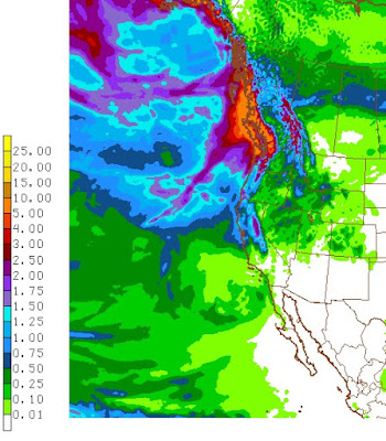
What about the next week? One weather system after another...with nothing serious (e.g., big winds or heavy rains). One-week totals from the NWS GFS model (below) are substantial (5-10 inches) over the Olympics, North Cascades and southern BC, and even northern CA gets wetted down.
And there is some good news for skiers.
Temperatures have been cooling, and although there will be some brief warm interludes, there will be snow at higher elevations above the mountains (particularly above 4000 ft). The 72hr total snowfall ending 4 PM Wednesday (below) shows several feet of new snow at elevation. Snoqualmie will be too warm. Sorry.

In general, a typical fall for our region.


I have been in full-on anticipation of lowland snow, since the announcement of La Nina, and temps expected below normal for northern tier of states, for Dec-Feb. Any long term forecast models indicating cold and snow in the not too distant future?
ReplyDeleteMt Baker Ski snow report looks good https://www.mtbaker.us/snow-report
ReplyDeleteBaker bus useful transit http://bakerbus.org/
Long-term forecasts are low skill under the best of circumstances, but predicting lowland snow in the PNW is the ultimate challenge.
ReplyDeleteHard to do even a day out because so many things can (and almost always do) spoil it.
The only solution is elevation. As in, having more of it.
It's interesting to note that the Medium Range models lately have been indicating a wx pattern in December more typical of an El Nino year than a La Nina one:ridging in Western Canada,and a big trough in the East.However,in La Nina years an abrupt pattern change to cold temperatures often occurs around,or just after, mid December.We'll see if this is the case again this year.
ReplyDeleteJust wanted to ask if you have any inside knowledge of the situation with KATX Level II data feed being inoperative for the past couple of days now. My favorite "avoid getting soaked" tool 'RadarScope' can now no longer do it's job and I am getting soaked this weekend because of it. :)
ReplyDeleteIf anyone is interested this gives a great overview of Level II data operational status:
http://radar2pub.bldr.ncep.noaa.gov/
Went cross-country skiing for the first time this season at Amabilis mountain (~10 miles east of Snoqualmie Pass) yesterday. The snow-pack has really been knocked down. We actually had to drive the logging road up to 3100 feet. The sun come out around noon (surprise!) for an hour or so, then a cold front hit, and it started to rain, which quickly turned to snow above 4000 feet.
ReplyDeleteHere in Glacier WA, as of today, I've observed/recorded 22.38 inches (10.66" in October, 11.72" so far in November). Wet, you betcha. And the snow level is pretty low right now - probably about 3,000' Temperature is dropping because it's clear. Winter, here we come!
ReplyDeleteSo much for Snoqualmie being too warm for snow. They've gotten 10 inches today and it's still coming down.
ReplyDeleteAbout that "too warm" comment... I've got a foot of snow on my deck in Hyak that begs to differ. Why is accurately forecasting the easterly flow such a challenge? Surely the folks in Sand Point are aware of it. Those who live in the pass know that when an east wind is in the forecast along with the words "little to no" it's going to result in shoveling "unexpected" snow. Is it a scale issue with the models? Are there not enough data points in the right places to predict it?
ReplyDeleteHopefully the easterly flow returns again tomorrow for another round :)