The interesting thing: they were directly connected. Let me explain.
Kauai by any measure is a wet place. But it is also a place of great precipitation contrasts. These contrasts are directly related to the terrain, with the two highest peaks being Kawaikini (5243 ft) and Mt. Waialeale (about 5150 ft.). Moist tropical air ascending this terrain results in huge amounts of precipitation.
The annual precipitation illustrates this (below), with much of the higher terrain soaked by over 150 inches a year. In fact, the heaviest average annual precipitation in the U.S. occurs at Mt. Waialeale with 460 inches a year-- much more than our Olympics, which enjoy the record for the highest total in the rest of the U.S. (about 150-180 inches a year on the windward slopes). The northern/northeastern side of Hawaii tends to have heavy precipitation since it faces the incoming trade winds, while the southeastern side (e.g, Poipu) is relatively arid, with only 20-40 inches a year. Most vacationers head to the south side of the island for obvious reasons.
Last weekend there were unimaginable amounts of precipitation hitting Kauai. Below are the 48-h totals for the 48-hour period ending at 6 PM HST on April 15, 2018 provided by the National Weather Service. All values are in inches.
Wainiha and Hanalei on the north side got huge amounts (28-32 inches). No wonder there was massive flooding. But Kalaheo on the southern side only had 1.55 inches (which is still a significant amount of rain)
Wainiha : 32.35
Hanalei : 28.41
Mount Waialeale : 22.34
Princeville Airport : 14.60
Kilohana : 13.19
North Wailua Ditch : 10.62
Kapahi : 10.12
Wailua : 8.21
Lihue Variety Station : 3.36
Anahola : 3.20
Lihue Airport : 1.92
Kalaheo : 1.55
A map of the 24h amount ending 9 AM HST April 15th shows the amazing contrasts. Keep this in mind when you consider a vacation in Kauai.
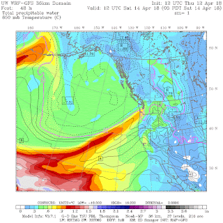
It turns out that there was a direct connection between the plume of moisture hitting Washington State and the moisture inundating Kauai. The UW model forecast for the vertical total of precipitation at 5 AM Saturday (PDT) shows this.
And a satellite-based measurement of moisture for the 12h ending 5 AM (PDT) Saturday, shows the connection, with Kauai getting hit by MUCH larger values (orange colors) than we endured.
And the connection was quite clear in satellite-based water vapor imagery, with the lighter colors indicating more water vapor in the upper troposphere.
But what caused the connection in moisture? An upper-level (500 hPa) map at 5 PM Friday (0000 UTC 14 April) shows an extensive upper level trough that extended back to Hawaii. The strong southwesterly flow associated with the trough (where the lines are close together) moved moisture into our area, while the trough extension over Hawaii contributed to vertical motion and precipitation there..
A surface map 12-h later (5 AM our time) shows a front approaching our coast, while a trough (area of low pressure indicated by the dashed lines) extended back towards Hawaii,with moderate northeasterly flow that rose up the northeast slopes of Kauai.
Hawaii and the Northwest have a lot of weather connections..... atmospheric rivers (which we call pineapple expresses) are, of course, one. But there is a lot more, including the ocean currents which, move water from off our coast to Hawaii.
And those currents will assist a brave UW student in rowing from the West Coast to Hawaii in June.
________________________________________
Announcement: The Northwest Weather Workshop is on April 27-28
The NW Weather Workshop is the big annual meeting for those interested in Northwest meteorology. This year we will have a major session on the meteorology of NW wildfires and others on other aspects of our regional weather. The gathering takes place at the NOAA facility in Seattle. To view the agenda and to register, go to the meeting website. The workshop is open to everyone, but registration is required.


No comments:
Post a Comment
Please make sure your comments are civil. Name calling and personal attacks are not appropriate.