June can have lots of clouds, and occasionally murky conditions can extend just beyond the July 4th weekend.
But then something wonderful happens: the clouds fade away, temperatures rise, and the chance of precipitation plummets. A magical period from roughly July 10 through early September when the coastal half of the Northwest has the best weather in the nation.
And it is going to happen right on schedule this year. But there is a dark side to this perfect weather: the potential for wildfires.
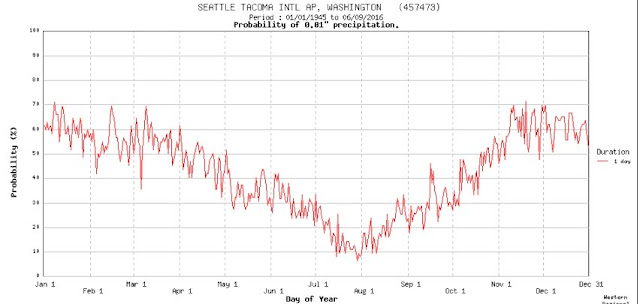
To illustrate typical conditions, here are the typical daily probabilities of measurable precipitation (at least .01 inch) at Seattle-Tacoma Airport. About 27% in late June and early July, but plummets to around 10-12% (and sometimes less) by mid July.
Best time for a wedding or outdoor party? The last few days of July!
The excellent weather.com forecast for Seattle shows a transition to sunny skies and essential no chance of precipitation starting on Wednesday, with temperatures increasing into the mid-80s. Warm, but not too warm, and dropping into the 50s at night. You will be able to sleep well, particularly if you have a fan.
But as I have talked about many times in this blog, one should always think probabilistically about forecasts, which means using ensembles of many forecasts. Below are the ensemble forecasts from the North American Ensemble Forecasts System (NAEFS) that combines roughly 40 model predictions from the Canadian and U.S. global ensembles. The predictions are for Seattle, with the horizontal line showing the median of the ensembles, the "whiskers" showing the range of the forecasts, and the yellow box indicating 50% of the forecasts closest to the median.
The forecast shows relatively cool temperatures through July 11th (Wednesday) but nice and warm after that (20C is 68F, 30C is 86F). A chance of light precipitation early in the week as well as some clouds... then dry and mainly clear.
Portland? Similar story, but a bit warmer.
Spokane? No precipitation. Temperatures getting into the uppers 80s to low 90s and not much clouds.
The 72h total rainfall ending 5 PM Friday shows nothing over Washington State and most of Oregon.
The downside of all this? The surface fuels (e.g., grasses, small bushes, debris on the forest floors) are going to dry out quickly during the next few weeks. Right now fuel moisture is in the normal range, but that won't be true by the third week of the month. The potential for wildfires will increase substantially.
One good thing is that there won't be much lightning, which is a major igniter of wildfires, particularly in remote locations. So people will have to be very careful not to start fires. No fireworks, no practice shooting in rural locations, only carefully controlled cooking fires, etc.


I've never heard of firearms starting fires before, so I did some quick research -- there's no solid numbers on it, but it seems that steel-jacketed ammo is a suspected culprit. And also exploding targets.
ReplyDeleteSo as in so many other contexts, some common sense would probably prevent a lot of the trouble.
...looks like 89 fire management specialist jobs just opened up at the USFS
ReplyDeletehttps://www.usajobs.gov/GetJob/ViewDetails/504283300
I would think that plant moisture would be pretty normal for the date now, and that given the forecast is for mostly climatic average weather, that plant moisture will remain normal for the forseeable future.
ReplyDeleteOf course, “normal” is for plants to get increasing drier through July and August until they become extremely dry.
Yet your blog says that plant moisture will be dropping below normal soon. I don’t understand why. Seems like plants would follow the usual moisture curve.
When conditions get dry enough, almost anything can start a huge blaze. During a short time in the Rockies at 8,000 feet, it was not uncommon to see fires begun by someone on a dirt bike gunning the exhaust among the brush.
ReplyDeleteAll I ask is that we stay below that 30C/86F mark all summer. We do that and I'll be happy.
ReplyDeleteThat's the trouble with the west- especially the pacific coast. I love the sun, but a solid shower- even a thunderstorm- with 1/2 to 1" of rain once a week in the afternoon or evening- would go far to prevent fires and keep things green.
ReplyDeleteFires are also started by people pulling off the highway into tall grass. The catalytic converter gets hot enough to set the grass on fire. There have even been cases of fires starting along the highway when a mower hits a rock and causes a spark. And for those of you who smoke, please don't throw your cigarette butts out the window. It doesn't take much to start a fire when the conditions are ripe.
ReplyDelete