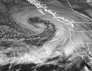
But forgetting about the wind and rain, there is something else about this storm: it is beautiful in shape and structure--a gorgeous spiral of clouds and complex structures. Let me show you.
Let's start with the GOES-17 visible image around 3 PM (below). Huge storm, with the frontal cloud bands spiraling into the low center. And if you look closely, the can see the mottled/speckled clouds of cold air instability spiraling into the low center. Very nice.
But we can do better than that: here is the view of the higher-resolution MODIS satellite around noon. Just stunning. The low center is in the middle of the spiraling clouds.
A closer look at the low center is found below. You can see the frontal cloud band (solid layer) and and instability clouds spiraling around on the outside.
By why stop there looking at this beautiful storm? Here is the water vapor imagery, showing you the amount of water vapor in the upper troposphere (roughly 20,000-30,000 ft). White means a lot of water vapor, dark means little in that layer. Cool, dry air is spiraling into the low center. Exquisite!
To serve as a comparison, here is the 1800 UTC (10 AM) sea level pressure and frontal analysis provided by the Weather Service; they estimated the central pressure as 980 hPa--a strong storm, but not an equal for any of greats (like the Inauguration Day-1990 or Chanukah Eve-2006 storms).
The model wind gust forecast for 1 PM today shows two areas of strong winds, on ewith the main front, that was battering the coastal waters at that time, and the second in the region just south of the low.
By 1 AM Sunday, the low center will be approaching landfall, just north of Vancouver Island, with the strong winds to its south. Just some spare change for us, here in WA State. Which is fine.


Aww great, just as I re-erected the rickety car canopy blown over in the last event. :-)
ReplyDeleteUp here on pat bay, Vancouver island, quite blustery now.
Alistair
Yes, this seemed to be a classic weather system. NWS seemed to get the forecast quite well on this for Bellingham.
ReplyDeleteI would be interested in what the jet stream is doing this year. It is something that TV weather folks like to talk about at times, but the discussion is usually not very informative. I also found it difficult to find very much discussion on the Internet on this year's pattern. I did come across the SFSU jet stream website that allows you to run 20 day loops using archives. When I tried to compare November 2017 and 2018, this year seemed weaker and farther to the north, but it was hard for me to really interpret it. Here are the links to both the current page analyses and the archives:
http://squall.sfsu.edu/crws/jetstream.html
http://squall.sfsu.edu/crws/archive/jetstream_archive.html