The models are all in agreement that a huge storm will develop a few hundred miles offshore on Tuesday and Wednesday.
A storm known as a "meteorological bomb" because its central pressure will deepen by more than 24 hPa in 24 hours
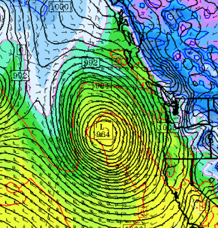
Below is the forecast from the UW model for 10 PM Wednesday: a deep 964 hPa low of enormous size. Strong pressure gradients and thus strong winds over a vast swath of the Pacific Ocean.
A simulated satellite image near the same time shows an enormous storm, with the associated fronts ranging over two thousand miles.
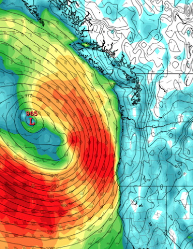
Strong winds will swirl around the storm for hundreds of miles as shown by the sustained winds on Thursday morning at 4 PM predicted by the European Center Model (solid lines are pressure, colors are sustained winds, with red/brown the strongest--red is 40 knots). A dangerous period to be sailing offshore.
Although remaining offshore, this storm will have substantial impacts along the West Coast.
With such a huge cyclone over the NE Pacific, with massive scale and powerful winds, huge waves will be created. For example, the NOAA WaveWatch3 model predicts that 20-30 foot waves/swell will arrive on the NW coast on Thursday morning (see below).
I suspect there will be some good wave-watching on the coast (but be careful if you do that).
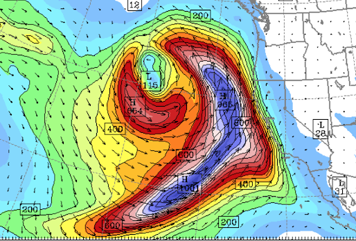
And to the southeast of the big storm there will be a plume of moisture that will run into California (see forecast for water vapor transport by the low-level winds for Wednesday morning, blue is the most).
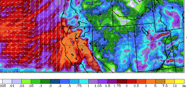
When this moisture is forced to rise by the substantial terrain of California, heavy precipitation will result (see the forecast of accumulated rainfall through Wednesday below). Very nice for helping to reduce the California "drought".
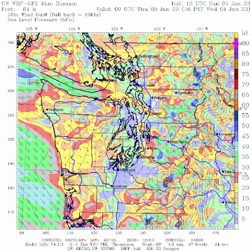
And finally, with a strong low offshore and higher pressure over eastern Washington, a large pressure difference will develop over the Cascades, resulting in strong winds over the western foothills of the Cascades, particularly in locations like North Bend and Enumclaw (see forecast gusts on Wednesday evening below--the dark blue and green colors are the stronger.) SeaTac Airport will get a piece of this.
For a meteorologist, a big storm is an interesting way to start the new year. And the latest long-term model runs suggest a lot more strong storms over the next 10 days. 😀 One could have our name on it...





What a monster storm
ReplyDeleteWait why is "drought" in quotes? Isn't California having an actual drought?
ReplyDeleteI'm sure Cliff hasn't a different reason for putting drought in quotes. But it's hard to argue that there's a water shortage when 47% of water used in CA is for livestock production (Pacific Institute
Deletehttps://pacinst.org › 2013/02PDF
California's Water Footprint).
if you've read Cliff's past postings on this subject, he's gone into great detail regarding the US Drought Monitor's protocols on establishing their relative measures on current drought conditions.
Delete"A storm known as a "meteorological bomb" because its central pressure will deepen by more than 24 hPa in 24 hours."
ReplyDeletePer Sanders & Gyakum (Synoptic-Dynamic Climatology of the "Bomb" - 1980) ... this is true only at 60° latitude. Elsewhere ... requisite the 24-hour pressure fall to qualify as a "meteorological bomb" needs to be adjusted for the latitude where the cyclone is analyzed as follows: sin(45°) / sin(60°)* 24 = 19.6 mb
They had a monster storm yesterday in Central California and Western Nevada.Near all time 24 hour precip totals;SF had second wettest day in 170+ years of record. Widespread flooding.Some places had more than one third of their 2022 rainfall on the last day of the year.( It was the only day of 2022 that the running annual precip total was above normal!)
ReplyDeleteThe ground is saturated and many rivers are near flood stage.If the upcoming atmospheric river sets up as predicted,it could be quite a disaster later this week.
Another year - Another bomb.
ReplyDeleteCould this be anything like the Great Coastal Gale of 2007?
ReplyDelete"global warming is making these kinds of winter storms, often called “bomb cyclones” for their associated rapid drop in atmospheric pressure and rapid development, more likely and more destructive." Jonathan T. Overpeck; Professor, Climate and Space Sciences and Engineering, University of Michigan
ReplyDeleteThere is no evidence for this claim. I know the papers on this issue and worked on it as well.
Delete"In the 30 years between 1961 and 1990, we detected low-pressure systems that met the criteria for a bomb cyclone 988 times, or an average of 32.9 times annually. In the 30 years between 1991-2020, we detected such systems 1,199 times, or 40 times a year, an increase of 21.4% compared with the first 30-year period." "The analysis was conducted in the North Pacific Ocean between 140-180 degrees east longitude and 35-50 degrees north latitude, where low-pressure systems are likely to affect Japan" University of Tokyo and Kyoto University
DeleteI think those results are clearly bogus. Why? Because our ability to observe developing storms has increased dramatically over time. If one looks looks at deep low-pressure occurrence at a single location, there is no increase. Model simulations show no increase.
DeletePretty impressive on the Satellite loop https://www.star.nesdis.noaa.gov/GOES/sector_band.php?sat=G17§or=np&band=GEOCOLOR&length=24
ReplyDelete