July 20, 2021

Fires on the West Coast Produce Smoke and Bad Air on the East Coast

 A remarkable situation is evident right now.   Fires over the western U.S. are producing a dense veil of smoke that moved across the continent and then descended over the East Coast.

And there is a great irony in all this: most of the West Coast has excellent air quality while the air is unhealthy over the northeast U.S.

To illustrate this strange situation, here is the latest AIRNOW air quality map showing the air quality based on PM2.5, small particles that can move deep into your lungs.  ( I want to acknowledge UW Bothell professor Dan Jaffe, who brought this to my attention)

Green is good air quality while red is unhealthy.  Really bad air quality in parts of New York, New Jersey, and Pennsylvania.  But air quality is really good along the West Coast!


You can visualize the movement of smoke by an image showing the smoke distribution at 11 AM this morning from the wonderful NOAA HRRR model.  Smoke generated over eastern Oregon, northern CA, and eastern WA moved northward around a ridge of high pressure centered over the Rockies and then headed southeastward towards the northeast U.S.


The smoke was quite apparent over the Northeast in the visible satellite imagery mid-day today (see below).  The grayish stuff is smoke.


The air reaching the East Coast has an interesting three-dimensional trajectory (the path of air in 3D space).  Using the NOAA Hysplit software, I found the origin of the air ending over New Jersey at 11 AM PDT today at 500 meters, 1500 meters, and 2500 meters above the surface ( see below).

Wow..the air reaching near the surface in New Jersey started over Washington State (red line).  First, the smoky air rose over the Northwest, gained altitude to catch stronger winds aloft, and then got mixed down to the surface over the East Coast.  A Washington import that may not be as popular as wine, apples, or cherries.


Kind of wacky, really..... start a fire here in the Northwest and the folks in the NY Metro area are choking in the smoke.

This kind of transcontinental smoke has happened before, but this event is particularly dramatic in terms of the air quality degradation along the East Coast.


July 18, 2021

A Favorable Short-term Forecast for Wildfires, and Satellite Technology for Wildfire Monitoring

Just as meteorologists were able to provide excellent forecasts regarding the heatwave, we are also able to contribute valuable one-week predictions of meteorological conditions that can lead to wildfires and smoke.

And the forecasts for the next week are favorable.

But before I provide those forecasts, let me show off some powerful weather satellite technology that really helps our society keep track of wildfire occurrence.

For example, our GOES (Geostationary Operational Environmental Satellite) covering the West Coast can spot the heat emissions from fires.  Below is the image from last night, with the orange colors indicating fires. Several little fires in BC and northeast Washington, but the big action is over south-central Oregon.  The biggest smoke plume too.


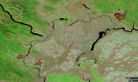
Other satellites (polar orbiting weather satellites) can view the earth in several wavelengths and can map out where fires have burned over the past several years.   Here is such an image for mid-day yesterday (Saturday).  The reddish areas are recent fires, while the green shows vegetation, including irrigated areas in the Columbia Basin.

A close-up view shows the recent Apple Fire near Wenatchee and the Chuweah Creek fire in the northwest portion of the image.  Not much smoke from them now.


The Regional Wildfire Forecast

Today, several of the recent grass/range fires are under control and there is cool, moist onshore flow across western WA and Oregon.  Most of the region is pretty much smoke free (see visible image)


Air quality is good (green circles in the AIRNOW graphic) for most of the region, with poor air quality limited to areas downstream of eastern WA and OR fires.


With a dry spring and the recent heatwave, the lower elevation fuels (e.g., grasses, bushes) are quite dry, and according to USDA Forest Service, they are ahead of schedule in drying by 2-3 weeks.  The Forest Service also notes a positive about the dry conditions:  less low-elevation fuels, since spring moisture promotes grass growth.

Another favorable is that the Northwest should not be warmer than normal:  no heatwave for us is in sight, as a moderate trough of low pressure is parked right offshore.

And there are some other positives for the next week.   

Many wildfires are started by lightning, particularly in remote, difficult-to-reach areas.
And the latest model forecasts suggest no lightning over Oregon, Washington, and southern British Columba.

And there is the question of wind.  Strong winds play a critical role in starting fires (e.g., trees falling onto powerlines) and contributing to rapid fire growth.   Fortunately, the latest model forecasts suggest a generally low-wind period.

The strongest winds east of the Cascade crest will during the late afternoon/early evening on the eastern slopes of that barrier, but even they will not be exceptional (see winds for the next week at Yakima below).

All this adds up to a period in which the meteorology will not be favorable for large, fast-spreading fires.  It should also give wildland firefighters a chance to make progress against current blazes.

But don't get me wrong....fuels are dry at lower to middle elevations and we must be careful to avoid starting new blazes.  

And we should also remember that wildfire is an essential part of the regional ecosystem and one that can not be excluded without eventually paying a heavy price, both in terms of enabling catastrophic large fires and in undermining the future health of our rangeland and forests.

A Fall Front Approaches

September is a meteorological transitional month in the Northwest.   The jet stream starts to strengthen and move south, while we begin to f...