After one of the most dismal periods of incessant clouds and rain in a long time, we are finally getting a break.
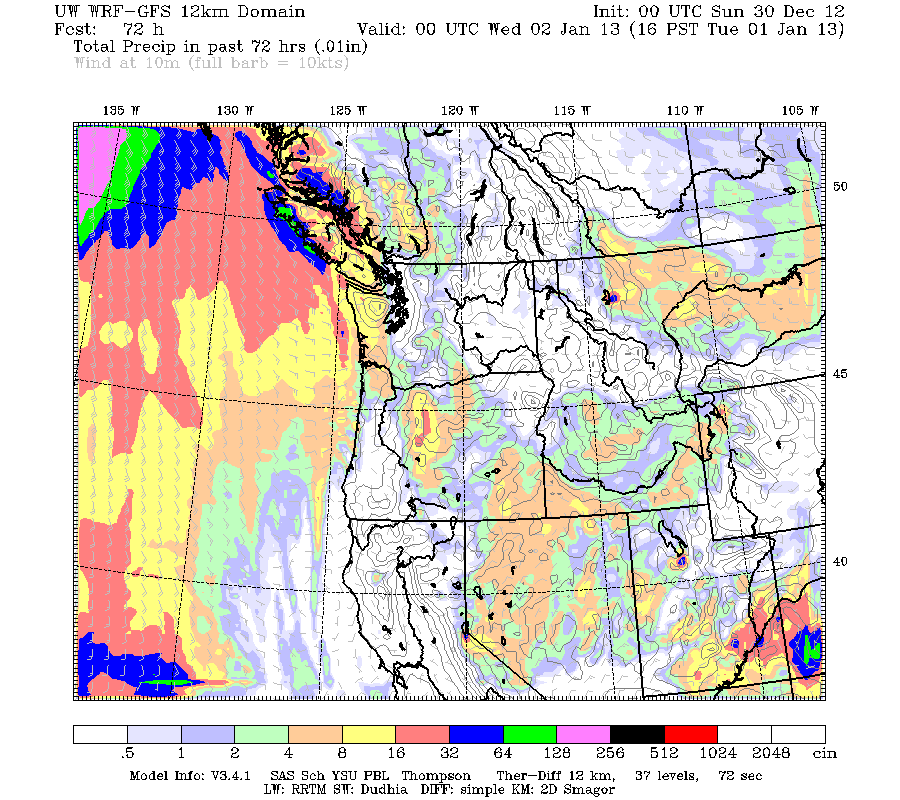
Here is the precipitation forecast for the next 72h. Although the NW coast will get some precipitation on Monday afternoon, most of western WA and Oregon will be dry.
The Climate Prediction Center prediction for the next 6-10 days is drier than normal for most of the west:
The origin of this boon is a major switch in circulation, with persistent ridging along the West Coast. Here are some sample upper level charts for Sunday and Tuesday:
What a wonderful opportunity to clean leaves out of your gutters and rake up leaves in your sodden yards....or to enjoy an outdoor walk or bike ride.
But with a wet surface and high pressure over the region (with attendant weak winds and clearing skies at night), expect a lot of fog, particularly in the morning. And if the temperatures drop below freezing, then roadway icing could be a threat.


I can't help but love the extended Gfs runs.
ReplyDeleteI'm hoping that it's on to something with it showing a massive arctic outbreak after day 10 or so.
I can dream right?
I'll be coming down on Amtrak in a couple days and I'm really hoping the Everett-Seattle run will be clear of mudslides. That stretch of track has been closed to passenger service for two weeks now.
ReplyDeleteCliff:
ReplyDeleteIt is Sunday morning Dec. 30 in Skagit County around 9:00 and not a cloud in the sky. Sun is burning off the fog. Suddenly, a few minutes later we are foggy with limited visibility and looking up there is no appearance of blue sky. It is now 1:30 in the afternoon and nothing has changed.
I have never seen this phenomenon in my travels. My thoughts are two possibilities. One is a front past and dropped the temps at or below the dew point or two we have received a moist air mass.
I have seen this a few times up here. We are not in the mountains or foothills and are in a flat area.
Why did we not have a sunny day here?
I, too, am "dreaming" that the extended GFS runs don't change! Shows cold air moving in around the 9th of January and by the 15th it's in full swing...with lots of moisture! Oh, yea! One can always hope and dream!!!!
ReplyDelete
ReplyDeletefor tree falls, add unusually saturated soils
Ack! What's this about the extended GFS models? A bout of snow would have been *lovely* during the holidays. But why must it inevitably hit once school's on and activities are in full swing?
ReplyDeleteWhen is the Arctic Blast heading our way? I'm dying for some lowland snow:-). Happy New Year!
ReplyDeleteHA! 4 miles NNW of Onalaska. Up about 620 feel. It's snowing! Have about 1/2" so far. Called some friends over in Adna. They're a lot lower. They have snow coming down, too.
ReplyDeleteBut then, we're in the Napavine triangle .... :-) .