Strong warm fronts are unusual in the Northwest. Our most frequent type of front is a warm occlusion, which brings unremarkable temperature changes, modest winds shifts, and wet weather. Occasionally we get a cold front. But rarely a warm front. For those of you who have not taken Weather 101, consider the classic evolution of a midlatitude cyclone (see graphic). We start with a wave on a stationary front. Where cold air is moving south you get a cold front, where warm air moves northward a warm front. The cold front (blue) moves faster than the warm front (red), eventually catching the warm front and in the process producing an new front that combines the characteristics of both...an occluded front (purple color on the figure). Occluded fronts are boring and uneventful in general.

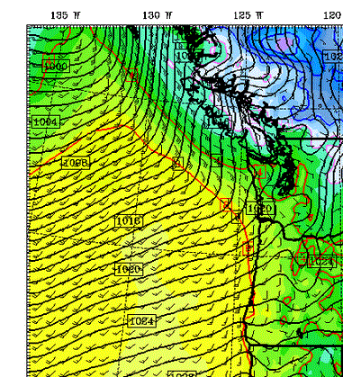
But sometimes we get lucky and a system revs up over the eastern Pacific and we get a decent warm front...and that happened during the past day. Here is a model forecast for Thursday morning (solid lines are surface pressure, shading is temperature at about 1 km above the surface, 10m winds are also shown). A very nice warm front. Southwesterly winds on the warm side and southeasterly winds on the other. Good temperature contrast (yellow is warmer) and a well-defined pressure trough (area of lower pressure).
As the front went through today along the coast and the Northwest interior winds switched to southerly or southwesterly and temperatures rose. Here is what happened at the UW (times are in GMT, 18 is 10 AM). Temperatures rose during the day into the lower 50s (third panel down), winds shifted to southerly (second panel), and wind speeds increased (top panel).


And take a look at the water vapor imagery Friday morning from a NWS satellite (it shows the amount of water vapor in the middle to upper troposphere).....a strong current of water from guess where? Hawaii! (whiter means more water vapor)

Fortunately, for Washington and Oregon most of this stream is heading just north of us, resulting in the heaviest rain over the next 48 h over Vancouver Island and southern B.C. Red colors are 5-10 inches! The Olympics and north Cascades will get a piece of this. Head south to escape it.

And remember that the NW Weather Workshop is today and tomorrow (see link in the upper right of this blog for more information). It will be a great meeting and one that should be generally accessible to layfolks.


"generally accessible to layfolks." What exactly do you mean?
ReplyDeleteThat water vapor image is absolutely gorgeous! Thank you.
ReplyDeleteCliff, this entry reminded me that what I call the "NOAA Global Precipitable Water streaming graphic" is available at: http://tropic.ssec.wisc.edu/real-time/mimic-tpw/global/main.html. You've shown the stills, including today's, but the time-lapse streaming images are beautiful and instructive. Maybe I can turn it into a screen saver. Much better than Video Aquarium. Please offer this to the folks viewing your blog.
ReplyDelete