Here is the visible satellite around noon on Friday. You can see the swirl of clouds associated with the low off of northern Oregon.

.jpg)
Here are a few cam shots on I5 near Eugene--this does not look like pleasant travel.


As the low moved south of Washington, easterly flow has increased over Washington State--thus air is approaching the Olympics through depth from an unusual direction...from the east. A plot of the winds over Seattle shows this change clearly (time increases to the left, the y axis is pressure, red lines are temperature). The atmosphere is cooling and the winds are easterly to 700 hPa (roughly 10,000 ft)

With easterly winds approaching the Olympics we are getting an interesting phenomenon...a convergence zone on the WESTERN side of the mountains, with an accompanying band of clouds and even some precipitation. Many are familiar with the Puget Sound convergence zone, in which westerly winds approach the Olympics, move around the Olympics at low levels, and converge over Puget Sound producing a band of clouds and precipitation (see graphic).
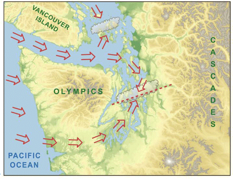
Now reverse the winds and you get a convergence zone to the west of the Olympics.
Let me prove it to you. Here is a MODIS visible satellite picture at 12:10 PM Friday. You see the band of clouds extending southwestward from the Olympics?...that's it. There are also clouds north of the Olympics, produced by the NE flow coming out of the Fraser River gap and passing over Bellingham and the San Juans before being forced to rise by the Olympics. Perhaps some snow over south Port Angeles!

We can get an even better view of the offshore convergence zone by viewing an image from the Langley Hill radar in Hoquiam (see below). An amazing image...you can see a narrow plume of precipitation in the coastal convergence zone.


A model forecast of the winds at 1 PM show the converging winds west of the Cascades.

The coldest temperatures are coming the next two nights...here is the forecast temperature at 7AM Saturday AM. 16-20F over many locations on the eastside of Puget Sound. Single digits and negative temps in eastern WA. Wind chills in the mountains will be brutal...below -20F will not be uncommon. Be prepared if you go up there.

Are you in venture capital/private equity and have an office in the Bay Area, or knows someone who does?
If so, I have a question for you. Please send me an email (cmass at uw.edu) ....thanks, cliff


fascinating as always doc. (so no goose-stepping snow zombies in metro seattle come tuesday morning?) thankee!
ReplyDeletea humble request, (easily ignored): since the UW local profiler link has been "temporarily unavailable" for over a month now, is there any hope of knowing the link that produced the slick profiler plot in this posting? thank you!
"Snow in South Port Angeles" was right on. I live about 5 miles south of Port Angeles at 1800 ft. elevation. It's been cold (<20 F) and cloudy and I've seen light flurries all afternoon today but no accumulation. Loved the sat photo of the convergence zone SW of the Olympics.
ReplyDeleteLake Dawn John
Convergence to the west is very cool. Happy Seattle missed the snow, but the kid in me is still a little disappointed.
ReplyDeleteHere near Lake Samish at 550 ft it was 10F this morning. Close to the coldest it has been in the past 21 years (7F). Probably colder tonight.
ReplyDeleteSteven
Here on Orcas Island, at the far eastern tip (Point Laurence) we are experiencing relentless wind and very cold temps. It's beginning to drive us crazy! Any clue as to when this wild weather will end? Limbs are falling and everything is frozen!
ReplyDeleteHere in Olympia--it's tooooo coooold!! I've been out tying up the boysenberries that fell off in the last big wind and I nearly got frostbite racing to net them from the deer before the sun went down. Looks like tonight will be the coldest. Stars have been great. Everyone--give the wild birds water please!!
ReplyDeleteLow This morning in Eatonville was 12.1....the high today, in blazing, bright sun was a balmy 28. An hour ago it was 26. Right now, at 5:02 it is already 18.8. It's gonna be a cold one if some clouds don't roll in soon! So glad we have a wood stove for heat. Our forced air heater would probably blow up trying to keep the house warm! If it's going to be this cold, why can't it just snow!!!!
ReplyDeleteCliff, as I take a break from studying for the weather final Monday to read this, I am so disappointed we will not get any decent snow during this cold snap!
ReplyDeleteNormally at least my Hood Canal scrapes out a couple inches, but probably not this time...
I must say though, that reverse convergence zone is pretty cool. It must be fairly rare.
I'm with windlover in all but name. That is to say, I'm more than happy the freight train that is the relentless northeaster has ceased to blow. But with no wind & temps this low, there really should be some snowflakes gently falling!
ReplyDeleteThis is turning out to be a once-in-a-generation snow and cold event here in Eugene and the southern Willamette Valley. It snowed for the better part of 12-14 hrs on Friday, leaving 7-9 inches accumulation. This snow has not melted at all, the roads are still compact snow and ice, and it looks like most of not all schools and universities will be closed tomorrow (Monday).The temperature dropped below freezing on the afternoon of Weds. the 4th and is not forecast to get above freezing until next Tuesday at the earliest. We get many fewer snow events than the Puget Sound region, but low temperatures during arctic outbreaks are often colder due to the lack of a moderating influence from the Sound. This time, with the added influence of the snow cover, night-time lows have been colder than any time in the past 41 years. The Eugene airport got down to -10 degrees F last night, not too far off the all time record of -15 degrees set in December 1972. The airport is located in a low spot in the valley and can get colder than surrounding areas - at my house in town I recorded -3 degrees. I checked the Wundermap at 8 AM this morning and it was interesting how much variation there was, from -6 at the airport to 10 degrees in the south hills, but most stations were in the low single digits at 8 AM (when temps had already started to rise). This is definitely the coldest that has been recorded in the 20+ years I have lived here. I'm expecting to lose the Zone 8 trees and shrubs I've planted in my yard over the years...
ReplyDeleteEd
I wish you were wrong about the snow. After freezing for days, I wish we would could have at least had a couple of inches of snow.
ReplyDeleteWhat in your opinion say about a White Christmas or at least a frosty on?
Saw a beautiful red sky at dawn this morning. What is the significance, weather wise, here in the Northwest?
ReplyDeleteI refer to the old saw - red sky in morning, sailor's warning
red sky at night, sailor's delight.
Chuck