We seem to be experiencing a reversal in seasons. November is normally wet and blustery, with a good chance of flooding and strong winds. March is generally a month in which the risk of flooding and high wind recedes.
November 2013 was dry over most of the Northwest, with 3.79 inches at Seattle Tacoma Airport, 2.78 inches below normal. February 2014 had 6.11 inches at Sea Tac, 2.61 inches above normal. March so far (5 PM Wednesday) has brought over 2.35 inches and much more is on the way.
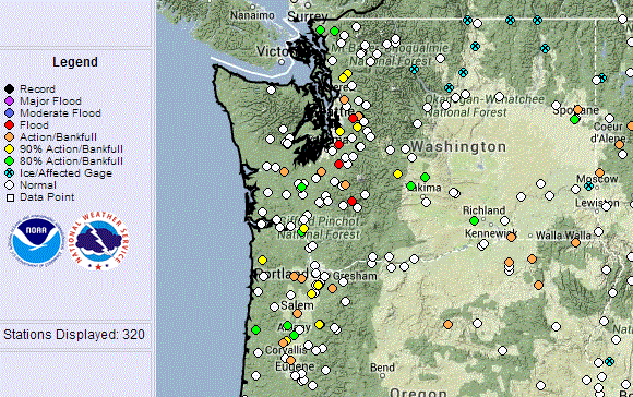
Flood levels are predicted by the Northwest River Forecast Center for a number of western Washington rivers (see graphic)
and the latest satellite image shows a line up of storms heading for the West Coast that really looks like mid to late fall (see image).


gauges soaked by 1.5-2 inches. And this is warm rain with a very high freezing level, leading to all kinds of avalanche problems in terrain.
And it is not over yet. To start with, it is pouring outside right now, with local urban flooding. But take a look at the precipitation forecasts for the next two 72 hr periods. In both time slices, the Washington Cascades get 2-5 inches, and even more in the mountains of BC. Washington snowpack numbers are starting to surge above 100% of normal. Oregon gets plenty as well, particularly during the second 72 hr. Oregon still has below normal snowpack, but there are moving up to normality fast. Most exciting of all this is that northern California gets substantial precipitation, further aid towards refilling the big reservoirs in that part of the State.


Take a look at Lake Shasta, the biggest reservoir in CA. The dark blue line is this year's storage, which is now heading upwards fast (the light blue represents normal conditions). Reservoir levels are now pulling away from the terrible 1976-1977 situation (red line).

And small reservoirs in S. California near LA are above normal after the huge rains last week, Here is Pyramid Lake:

The reason for all this early winds warmth and precipitation: a shift to persistent southwesterly flow aloft:

Want to experience spring time warmth on Friday and Saturday? Head to the Tri-cities where the low to mid 60s will be waiting for you.


Hi Cliff,
ReplyDeleteI have a friend that has just recently moved here permanently from SoCal, and I was just telling her today that this weather is very indicative of November instead of March. She is trying to adapt but out Fall and Winter are sooooo mixed up.
I'm just glad we are receiving the rain finally but someone needs to turn off the faucet!!!
Cliff- I love your blog and continue to learn much from it. Being a relocated southern California hydrogeologist, your blog has been more than useful.
ReplyDeleteI wanted to point out that southern California lakes are usually reservoirs for imported water , with their water levels being primarily controlled by water allocations between water agencies. So, while the water levels in these reservoirs will generally fluctuate with precipitation they can also be full during periods of drought, especially during early signs of a prolonged drought.
November was unusually dry, but March thus far doesn't seem terribly out of whack. It tends to be a challenging month, weather-wise. Historically, the most significant flooding in Whatcom County has happened in January & February. Flooding in November & March tends to happen on an equal opportunity basis.
ReplyDelete"And small reservoirs in S. California near LA are above normal after the huge rains last week, Here is Pyramid Lake:"
ReplyDeleteIf I am reading this plot correctly, Pyramid Lake has not been a problem since 10/13.
El Nino is coming! Get ready for the wild ride!
ReplyDeleteThis little graphic illustrates the rain this February and March is not 'normal' and is approaching in scale other notable recent rainy stretches.
ReplyDelete