The Pacific coastal water from south of the Columbia River outfall to the tip of Vancouver Island to the north (see map below), is commonly known as the Graveyard of the Pacific, and for good reason. You start with abruptly rising rocky coasts, add strong winds, and mix in low visibility from incessant fog and rain.

The blue region on the map is known as the Graveyard of the Pacific
Strong winds, sometimes reaching hurricane strength, batter the Washington and Oregon coasts in winter and the foggiest location in the continental U.S. is Cape Disappointment on the northern terminus of the Columbia River (with 106 days a year of dense fog!). The interaction of the westward moving flow of the Columbia River and incoming waves produces the dangerous Columbia Bar (see picture), with large waves and threatening shoals. Strong easterly winds exit the Strait of Juan de Fuca, frequently reaching 60-80 mph.

The Columbia Bar is treacherous for marine passage

A variety of obstacles greet the mariner at the western entrance to the Strait of Juan de Fuca
These dangerous conditions have produced hundreds, of not thousands of shipwrecks, along the Washington, British Columbia, and Oregon coasts (see figures). Most of these shipwrecks were between 1850 and 1950 and modern navigational aids have dramatically reduced the threat. But the threat is still there...strong winds, low visibility, rocky shorelines.


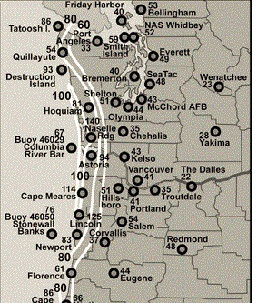
The Northwest may not get hurricanes, because our water is too cold, but our strongest cyclones have winds equaling that of category 1 or 2 hurricanes, and our storms are far larger in size. Our shores are no stranger to 100 mph winds, as illustrated by the recent December 1-3, 2007 coastal gale (see map)
Our offshore conditions are so severe that the National Weather Service can not maintain our offshore buoys: most are broken or adrift today.
Coal and oil ships from Puget Sound and Northwest Washington (e.g., Cherry Point near Bellingham), must exit the Strait of Juan de Fuca, a waterway infamous for strong and often poorly predicted winds. When air pressure is higher inland and lower offshore (very frequent in winter), the winds accelerate to the west, often reaching 60 mph and more at and east of Tatoosh Island, at the Strait's western terminus--a danger to shipping recognized for many years (see article below)

Here is a simulation from the modern WRF weather prediction model for a modest esaterly case in 2010, with winds only getting to 60 knots near the western entrance.

And when fronts moves eastward across the region or marine air surges into the Strait during summer onshore marine pushes, westerly winds can increase to 60-90 mph over the central and eastern Strait. One of these events destroyed Ivar's Mukilteo Landing restaurant in 2003 and another heavily damaged the Ferry Elwha in Everett Harbor and caused a huge blackout over Snohomish County.


But far more dangers await coal and oil ships heading towards the proposed mega terminal at Cherry Point. First, to get from the Strait to the terminal they have to wend their way through a maze of narrow passages and islands (see map).

And a major meteorological lurks in this area: strong northeasterly winds pushing out of the Fraser River valley. When there is cold, high pressure in the interior of British Columbia and lower pressure over western Washington, air can accelerate down that gap, often reaching 40-50 mph north of Bellingham and out towards the San Juan Islands. Yes, we are talking about right over the Cherry Point terminal. These winds can be as strong as 80-90 mph, as illustrated by the event of December 28, 1990 (see map below). The inner dotted line indicates winds exceeding 40 meters per second--that is about 90 mph!

And here is what happened at Anacortes Harbor that day, or what was left of it. Let's say many of those boats never floated again.

Not only do the Fraser gap winds make marine traffic difficult if not impossible when they are active, but they would blow coal dust from Cherry Point over the San Juan Islands. What's not to like?


Strong winds, dense fog and poor visibility, landslides, sand bars, rocky coasts, strong wind shear, and more. Northwest waters are uniquely threatening to oil and coal ships, at the same time our environment is uniquely vulnerable to a major spill, including a huge shellfish industry and valuable fisheries. Acting as a huge coal/oil port makes no sense for us. And it is particularly senseless because the huge carbon export will come back to harm us in two ways: (1) make a large contribution to CO2 in the atmosphere and thus global warming, and (2 ) some of the the pollution from burning the coal and oil will be spread across the Pacific back over the Northwest.
Marine safety has improved dramatically over the past 50 years, there is no doubt about that. But human error is still with us, as shown dramatically by the recent sinking of a Korean ferry, the grounding of a cruise liner off Italy, and the loss of the Exxon Valdez in 1989, to name only a few. Huge increases in the number of oil and coal ships entering our waters enhance the risk that human error will lead to an environmental catastrophe for our region. And for what?
Life is always about risk versus reward. In this case, the former is far, far greater than the later.

The grounding, break up, and burning of the new Carissa in 1999 show the threat of ship wrecks continues today. Oil from the ship polluted the coastline.
Climate 101 Luncheon on Monday in Seattle
If any of you are interested, I will be participating in a Climate 101 luncheon sponsored by the Seattle Chamber of Commerce and mc'ed by Jeff Renner of KING TV. There is some space left. For more information go here.


Cliff: While not in the Pacific Northwest it would be interesting to get your take on the ship passage through the Aleutian Islands. The ships use a great circle route that takes them though narrow ocean passages in the Aleutian Islands.
ReplyDeleteMr. Mass:
ReplyDeleteWhilst I understand your opposition to the export of natural resources, and expertise in weather matters, the marine portion of your argument is in error. The "Graveyard of the Pacific" gained it's reputation long ago, before both modern ships and navigation aids (as noted in the Wikipedia article you took the chart from). It is not a "maze of narrow channels" from the mouth of tje straight of Juan de Fuca to the Cherry Point Oil Refinery but a wide and heavily regulated vessel traffic route (no narrower than 2 nautical miles). Both CDN and US CG VTMS systems have excellent overlapping coverage of the entire route. Having steamed these waters (and all over the world)for more than 25 years they are safest in the world. A combination of low traffic, wide traffic lanes, and no `hostile` nation states nearby. I defer to your knowledge of weather. Aloha TCM
Where would alternative port for oil & gas ships be, in terms of coastal safety?
ReplyDeleteIt's too bad to see you take sides in this. I always liked your blog because you seemed to cut through all the sensational BS the TV networks do. Now you're posting pics of shipwrecks that happened long before pilots, radar or any modern navigation and what's up with his pic of the Columbia River Bar? That's the coast guard practicing just off shore outside of the channel and protective jetty not at the entrance of the bar. Ships that enter the waters of Puget Sound are built to withstand storms in the middle of the Pacific. What you are taking about in Puget Sound is really only a worry for small pleasure crafts (hence the small 45' Coast Guard vessel you show) not ships.
ReplyDeleteTCM,
ReplyDeleteMost of the shipwrecks were between 1850-1950. But the risks are still there and will increase as shipping of oil and coal increase. As the Korean ferry incident shows, human error is still with us, with modern navigation aids...cliff
This article doesn't even begin to address the challenges of attempting to clean up an oil spill in the PNW. All the challenges to shipping, exponentially compound the clean up problems. Combine that with new types of crude - alberta tar sands and Bakken Crude - and it is a recipe for utter disaster to all that live here, oil that would possibly last for decades if not centuries in the environment.
ReplyDeleteThe areas in Alaska around the Exxon Valdez spill still have crude oil on the beaches, and are not even close to recovering 25 yrs later.
The chance might be small, but the price would is so high it's not worth it. Perhaps a post on the weather challenges to cleaning up an oil spill would be a good follow up to this one. :)
I just returned from Orcas Island, and while I was looking out to the west, I saw a large tanker traveling through Rosario Strait. I thought about what might happen if there was a spill, and I couldn't imagine what would happen to the San Juan Islands if a large spill occurred.
ReplyDeleteSeveral of the commenters here seem to have completely forgotten about the Exxon Valdez spill. Even with the best technology, and the most experienced crews, human error is always a possibility. Do we really want the Salish Sea to become another Prince William Sound (which still hasn't recovered, 25 years later)?
Cliff, you didn't even mention another significant problem. When high winds blow against the strong currents in Haro, Rosario and Juan de Fuca Straits — say a gale-force south wind blowing against an ebb tide in Haro Strait — the conditions on the water can become truly frightful. Under such extreme conditions, the likelihood of human error increases markedly and the margin for error drops accordingly.
ReplyDeleteEven in comparatively calm conditions, such error occurs, as happened in the Cape Apricot incident on 7 December 2012, which took out a causeway at the Westshore Terminal and dumped over 30 tons of coal into Georgia Strait waters. Canada's Transportation Safety Board recently attributed the incident to pilot error and poor communication with the captain and tugs.
All risk No reward. Clean water and productive fisheries are worth far more to many more people in the PNW than the few short term jobs that will result from exporting fossil fuels.
ReplyDelete"Are Pacific Northwest Waters Too Risky for Oil & Coal Ships?"
ReplyDeleteCliff, you could have just typed: 'Hell Yes! They're too risky!!!' ;)
(Even better, if we imagine you sounding like Samuel L. Jackson, while reading it...)
Breaking news: Oil tankers have been docking at the refinery near Anacortes since the 70's, without a single notable incident.
ReplyDeleteUnknown..more breaking news... in that case the REFINERY has blown up or exploded several times..has to make you feel good about the risks, doesn't it?..cliff
ReplyDeleteUnknown,
ReplyDeleteIt says something about human error and the explosive nature of fuels...highly relevant issue...cliff
People need to start taking the ecological effects of human actions into account over economic benefits. If residents of the PNW allow coal and oil shippers into our waters than it does put our environment in jeopardy. We need to stop thinking about the economic benefits of shipping coal and start thinking about the ecological benefits of keep coal out.
ReplyDeleteI think the larger picture here is that PNW residents need to fight for their right for clean air and water. After we stop the coal terminals, we need to improve the water quality of our storm water runoff!
This blog is so relevant in exposing the deepening risk of last ditch efforts to save the carbon extraction industry that it would be nice to see it widely published. Could the GPT at Cherry Point not become climate "ground zero" for a West Coast based climate justice social movement?
ReplyDeleteThose who have observed that the risks are not worth the gains to be had by a few short-term jobs are entirely spot-on.
ReplyDeleteThanks, Cliff, for calling attention to the hazards involved in this venture.