The forecast problem today regarding Hurricane Joaquin is extraordinarily similar to the one faced by meteorologists during the week before Sandy made landfall. Amazingly similar but with an interesting twist.
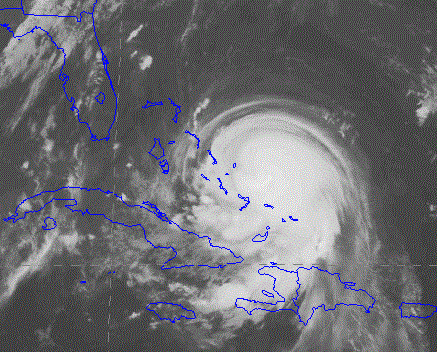
Hurricane Joaquin at 8 PM Wednesday
Just as with Sandy, one major forecast model is bringing the hurricane inland with a "left hook" while the other is taking the storm out to sea. But in this case, the situation is reversed....the latest (Wed evening) U.S. GFS model is taking the storm inland over New York with heavy precipitation and strong winds. In contrast, the usually (but not always) superior ECMWF model is pushing the storm out to sea.
Let's look at the latest forecast, starting with the U.S. GFS model (lines are isobars of constant pressure and shading is precipitation). One can hardly believe one's eyes: New York/New Jersey is in the crosshairs.


But before New Yorkers panic, I should note there is a great deal of uncertainty in this forecast. The previous runs of the GFS model took the storm into North Carolina and Virgina, so the modeling system has not stabilized on a solution. Furthermore, the GFS model ensemble system (GEFS), in which the model is run many times with different initial conditions, is producing a wide variety of tracks and intensities. Here is the 90h forecast of GEFS (previous run at 1800 UTC today), presented with what is known as a spaghetti diagram, with each lines representing the 984 hPa isobar (line of constant pressure). You see the circles all over the place and of different sizes? That means a lot of uncertainty.

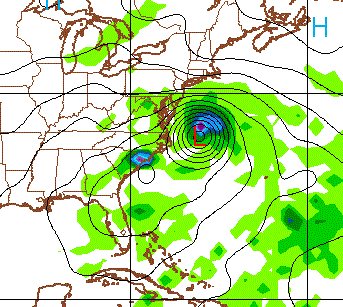
The GFS and GEFS are run at relatively coarse resolution (13 km and 50 km grid spacing, respectively). The National Weather Service has its high-resolution HWRF model (4km grid spacing) that cost tens of millions of dollars to develop....what does it show? (see below). Interesting, HWRF is going further south of the main GFS model.

Saturday at 5 PM PDT


There is substantial uncertainty with the ECMWF forecast, something we can explore by looking at the output of their ensemble system. Here is their high-resolution forecast (solid lines, isobars of constant pressure) and variability in their ensemble (shaded colors) for 1200 UTC on Monday (5 AM PDT). The shading to the left of the high resolution low center suggests that some of the forecast took the low farther to the west.

The National Hurricane Center puts out a subjective forecast based on looking at all the models, tempered by human experience. Their solution? Take the hurricane up the coast over DC. This would shake things loose in the nation's capital....maybe encourage the purchase of a better weather supercomputer!

And one thing that is pretty sure-- no matter what happens: the East Coast will be hit by heavy rain. Here is the cumulative precipitation through Tuesday at 5 PM. Five to 15 inches along the coast.

So what should you take away from all this?
A dangerous hurricane is moving northward but the track of the storm is still highly uncertain. Major international modeling systems disagree. Their ensemble systems (many forecasts run with slightly different initial states) disagree. Consider the trending of the GFS model farther northward each run and the stability of the EC solution, I suspect the storm will track into New England or just offshore, but it is impossible to be sure at this point. HWRF seems to be going the wrong way (too far south).
Folks should not panic, but those from Cape Hatteras to Boston should watch the forecasts carefully and begin preparations. Hopefully, the models will converge during the next day to a robust solution.


Hurricane Bob in 1991 made first landfall straight over Block Island, RI. What are the chances this one will beeline there?
ReplyDeleteIt's still heading straight for Cuba right now, with a SW path. It was not predicted to head that far SW. In order for it to follow the predicted bath at this point it would need to do a immediate "on a dime" 180 degree turn to the NNE.
ReplyDeletehttp://images.intellicast.com/WxImages/SatelliteLoop/hifloat2_None_anim.gif
http://www.spaghettimodels.com/
I get the feeling it's going to sag to the SW as it skims along the florida coast, eventually turning NE back into the atlantic.
Great and interesting facts to read. I'll stay tuned from Bayville on Long Island Sound in NY
ReplyDeleteHeading to Savannah, GA for a conference tomorrow... I suspect I'll at least see some major rain... But as much as I'd like to experience a hurricane, I'm kinda glad it's staying off the coast!
ReplyDeleteThe European model looks like the clear winner here. Interesting NYT article about this and Cliff you have brought this up in the past as well.
ReplyDeletehttp://www.nytimes.com/2015/10/03/upshot/hurricane-joaquin-forecast-european-model-leads-pack-again.html?hp&action=click&pgtype=Homepage&module=second-column-region®ion=top-news&WT.nav=top-news&_r=0
While looking for model animations for the hurricane, I stumbled across an extraordinarily neat tool for visualizing winds (and weather in general) on a global basis.
ReplyDeletewindyty.com
Playing it forward slowly over the next week is mesmerizing. As expected, the PNW looks pretty boring, but the Pacific is astoundingly active compared to the Atlantic, even with an Atlantic hurricane in the news.
John
Once again, much ado about nothing. Makes me wonder: if we can't accurately predict something of this magnitude several days out, how can we hang our scientific hat on predicting the impact 'global climate change' will have through the 21st century?
ReplyDelete