Time for the July 4th forecast, and we are close enough that skill should be good.
The bottom line: current warming (caused by high pressure aloft) will be followed by a cool-down as an upper-level trough approaches.
This morning, the Northwest was clear except for the typical June low clouds along the coast:

During the next 48 hours, a transient upper-level ridge will be positioned over southwest Canada, allowing temperatures to rise into the 80s in western Washington and mid to upper 90s over eastern Washington (see upper level map, 500 hPa, around 18,000 ft today).

The high temperatures as of 4 PM today (Monday) are shown below. 50s and 60s on the coast, 80s over the Puget Sound lowland, and 90s in the Willamette Valley. Toasty east of the Cascades.

Tomorrow will be similar. But then the situation will change significantly as a complex collection of low-pressure troughs approaches the region (see the upper level map at 11 PM Thursday) as the ridge of high pressure moves eastward.

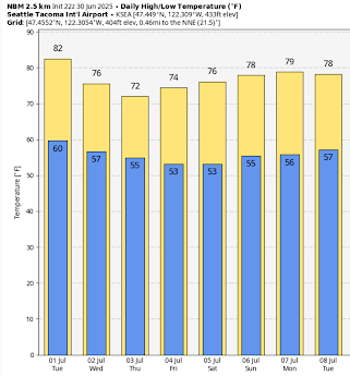
Consider the forecast temperatures for Seattle (below). Lower 80s on Tuesday, followed by a decline into the mid to lower 70s.
In the Tri-Cities, temperatures near 100F will decline into the "cool" upper 80s.

What about precipitation?
The predicted ten-day total is shown below. Precipitation over northern BC, Idaho, and Montanta. Eastern Oregon gets a few showers. But nothing really over Washington.

Strangly enough, this has a silver lining: no forecasts of thunderstorms over WA state, which means fewer fire starts.
Which is a reminder to be careful with fireworks...or avoid them completely.


Yes to avoding personal fireworks! There are plenty of spectacular public displays to attend; please consider our kids, property and pets as we celebrate our cherised independence and freedom
ReplyDeleteIt's about liberty, not freedom. They are not the same thing.
DeleteLooking like a nice long stretch of 80s starting next Monday summer is here to stay.
DeleteI strongly agree with this. Fireworks should be left to the professionals who know how to handle them properly. It is much safer for everyone that way.
DeleteWhile the late spring-early summer period has been concerningly dry around the Bellingham area, unlike most of the rest of the state, it has not been hot. The first day with a max temp of 80F or higher was right on schedule, the first day with a max temp of 85F or higher will occur later than normal as will the first day with a min temp of 60F or higher. My garden of cool/cold weather-loving plants has been very happy given plenty of water for irrigation.
ReplyDeleteThis is off topic but I’m curious about your thoughts. https://www.axios.com/2025/07/01/noaa-document-deep-trump-cuts
ReplyDelete