September 30, 2015

Will Hurricane Joaquin Be This Year's Superstorm Sandy?

Superstorm Sandy struck the NY metropolitan area during the last week of October 2012, result in 233 deaths and 75 billion dollars in damage.

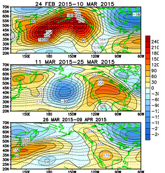
The forecast problem today regarding Hurricane Joaquin is extraordinarily similar to the one faced by meteorologists during the week before Sandy made landfall.  Amazingly similar but with an interesting twist.  

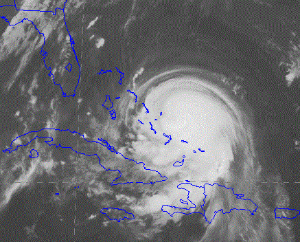
Hurricane Joaquin at 8 PM Wednesday

Just as with Sandy, one major forecast model is bringing the hurricane inland with a "left hook" while the other is taking the storm out to sea.  But in this case, the situation is reversed....the  latest (Wed evening) U.S. GFS model is taking the storm inland over New York with heavy precipitation and strong winds.  In contrast, the usually (but not always) superior ECMWF model is pushing the storm out to sea.

Let's look at the latest forecast, starting with the U.S. GFS model (lines are isobars of constant pressure and shading is precipitation).   One can hardly believe one's eyes:  New York/New Jersey is in the crosshairs.  


But before New Yorkers panic, I should note there is a great deal of uncertainty in this forecast.  The previous runs of the GFS model took the storm into North Carolina and Virgina, so the modeling system has not stabilized on a solution.  Furthermore, the GFS model ensemble system (GEFS), in which the model is run many times with different initial conditions, is producing a wide variety of tracks and intensities.   Here is the 90h forecast of GEFS (previous run at 1800 UTC today), presented with what is known as a spaghetti diagram, with each lines representing the 984 hPa isobar (line of constant pressure).  You see the circles all over the place and of different sizes?  That means a lot of uncertainty.


The GFS and GEFS are run at relatively coarse resolution (13 km and 50 km grid spacing, respectively).  The National Weather Service has its high-resolution HWRF model (4km grid spacing) that cost tens of millions of dollars to develop....what does it show? (see below).  Interesting, HWRF is going further south of the main GFS model.


Now lets turn to the supposed Gold Standard weather forecast model, the European Center Model (ECMWF).  The European Center model takes the storm northward and then out to sea towards the northeast, as shown by the following forecasts initialized at 1200 UTC today (Sept 30th).

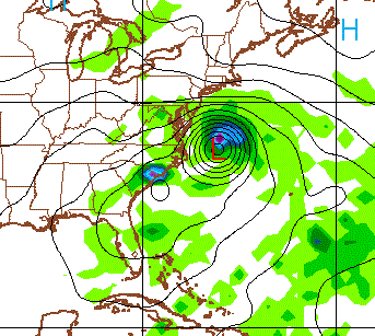
Saturday at 5 PM PDT
 Monday at 8 PM
 Tuesday at 11 AM PDT

There is substantial uncertainty with the ECMWF forecast, something we can explore by looking at the output of their ensemble system.  Here is their high-resolution forecast (solid lines, isobars of constant pressure) and variability in their ensemble (shaded colors) for 1200 UTC on Monday (5 AM PDT).  The shading to the left of the high resolution low center suggests that some of the forecast took the low farther to the west.


The National Hurricane Center puts out a subjective forecast based on looking at all the models, tempered by human experience.  Their solution?  Take the hurricane up the coast over DC.  This would shake things loose in the nation's capital....maybe encourage the purchase of a better weather supercomputer!


And one thing that is pretty sure-- no matter what happens:  the East Coast will be hit by heavy rain.   Here is the cumulative precipitation through Tuesday at 5 PM.  Five to 15 inches along the coast.


So what should you take away from all this?

A dangerous hurricane is moving northward but the track of the storm is still highly uncertain.  Major international modeling systems disagree.  Their ensemble systems (many forecasts run with slightly different initial states) disagree.  Consider the trending of the GFS model farther northward each run and the stability of the EC solution, I suspect the storm will track into New England or just offshore, but it is impossible to be sure at this point.  HWRF seems to be going the wrong way (too far south).

Folks should not panic, but those from Cape Hatteras to Boston should watch the forecasts carefully and begin preparations.  Hopefully, the models will converge during the next day to a robust solution.


September 28, 2015

A Perfect Autumn Week

I know many of you are looking forward to rain and clouds, but they will come soon enough.

In the meantime, enjoy an extraordinary fall week, with temperatures getting around 70F, no rain, and lots of sun.  And the bite of crisp temperatures in the morning to ensure you feel invigorated and alive.

The temperatures during the past four weeks have been very close to normal, as shown by the plot below (red and blue lines are average highs and lows)
Precipitation has been a bit below normal during the same period (blue is normal, red observed), by roughly .7 inches.
Want to see something amazing?  Here is the total precipitation predicted though Saturday at 5 AM (from the GFS model)  Nothing along the U.S. West Coast-:  WA is entirely dry.   But the  East Coast gets washed away.  SE Alaska gets torrential rain as well.


The pattern producing this weather is really not exceptional (see upper level map below for tomorrow afternoon).  A deep trough over the Gulf of Alaska is trenching Alaska, while a weak ridge is stationed over the western U.S. and Canada.  A weak trough is off of our coast.

The National Weather Service forecast for the next four days is  as close to ideal as imaginable (see below), with highs around 70 and lows near 50 (colder away from water). Sun.  No rain.


Last night some of the cooler suburbs southeast of Seattle dropped into the mid-30s...and that was at 2-m above the surface.  Some folks surely had frost.  In contrast, the temperatures only dropped to the mid-50s at some locations near the water. (the 92 was probably a thermometer near someones grill).  I am always amazed by our local contrast on cold, clear nights.  20F differences is not unusual...can get to 30-35F in the right situations.


This good weather won't last forever.  The latest NAEFS North American ensemble forecast of many model predictions indicates more clouds and some rain by the second week of October (see below).   So enjoy this pattern while you can.


September 26, 2015

Perfect Sky Conditions Tomorrow for Supermoon Eclipse

Tomorrow (Sunday) night around sunset, Northwesterners will be able to enjoy a rare supermoon total eclipse with no clouds impeding the view.

We start with supermoon, a full moon that is unusually large and bright because of the moon's unusual proximity to the earth. Specifically, that moon will appear 14% larger and 33% brighter than normal. The moon's orbit around the earth is an ellipse, with the distance between the two varying between 222,000 and 252,000 miles.


Then. on top of that we will have an eclipse, with the earth lined up with the sun to eclipse the moon.  The combination of supermoon and a total eclipse is relative rare, with the last one occurring in 1982


 and the next one in 2033.  Even more impressive and unusual, this lunar eclipse is the last of a series of four, called a tetrad.

Supermoon events are often called blood moons, because the moon can have a reddish hue from light scattering off the Earth's atmosphere.  Here in the northwest, the eclipse will start at 6:07 PM and totality will last from 7:11 to 8:23 PM, when the sky will be quite dark.

The latest weather forecast model runs indicate clear skies over the region during the eclipse.  Here is the cloud prediction from the UW WRF model for 8 PM.   No clouds over Washington and Oregon.


So head to a nice view point tomorrow and enjoy a special celestial show.

But there is more.  Some folks believe that blood moon eclipses are particularly attractive to werewolves and vampires, so you might be a bit careful, particularly if you live in or near Forks. Other believe that a supermoon eclipse ending a tetrad might signal the end of the world.  So you might want to put your affairs in order on Sunday, just in case.


Viewing Tip
     A hill looking east would be good. In Seattle, the kite hill at Magnuson Park is nearly perfect, with a view across Lake Washington.  That is where I will be tonight.

Bicycle Weather Talk

THURSDAY, OCT. 1
I will be giving a talk: A cyclist's guide to weather information: how to increase your chance of a dry ride
Doors open at 6:30 p.m., presentation begins at 7 p.m.
Cascade Bicycling Center
7787 62nd Ave NE, Seattle
Free

September 25, 2015

Drought in 2016 for Washington State?

This morning the Washington State Dept of Ecology held a press conference and released a statement predicting continued drought in the our region.   They forecast a dry fall, lack of snowpack, and conditions as bad or worse than this year.  The media, of course, picked up the story and amplified it a bit.


And state officials were busy tweeting about the coming drought situation.


The media and public officials are talking about a strong El Nino, a continued blob, the effects of global warming.  Some things they are getting right, but there is a substantial amount of confusion and wrong information being given to the public.

Let's examine what we really know.   And as I will show, the odds are that next year will bring substantial IMPROVEMENT over this year regarding snowpack and drought.

The first thing to keep in mind is that the key weather feature that has kept us warm and dry, the large high pressure area over the West Coast and eastern Pacific, is no longer there.

I can prove it to you.  Here are the anomalies (difference from normal) of the heights of a mid-tropospheric level (500 hPa) first for last spring (left) and for the last three weeks (right).  Red indicates higher pressure than normal (ridging) and blue below normal (troughing)


Can you see the profound difference?  The ridge is gone and there is no hint it is coming back.  In fact, the current strong El Nino will make sure of that.

We made change to a more normal pattern during the latter part of August, resulting in the return of precipitation to our region.   In fact, here is a plot of the difference of precipitation from normal for the past month.  Precipitation has been ABOVE NORMAL over more than half of the State, with some portions (north Cascades and Olympics) being hugely above normal.  This is not a drought pattern.

The new flow pattern has also had a large impact on temperatures, greatly cooling off our state.  Here is the difference of surface air temperature from normal the last month (the anomaly).  COOLER than normal over most of the state, particularly over the wildfire areas of eastern WA.
With the lessening of the warmth and return of rain, wildland firefighters have put out or controlled most of the fires.  Fire season is essentially over now.

So the main reason that we were so dry and warm (the eastern Pacific High pressure) is now gone.  And furthermore, its direct offspring, the BLOB (the area of warm water off our coast), is rapidly weakening.  To demonstrate this, here is the change of sea surface temperatures over the past month.
Blue is cooling.   The BLOB is in its death throes.  Sad, but true.


All good news, right?  But then there is the scary El Nino threat.  A very strong El Nino (warm sea surface temperatures in the eastern tropical Pacific) is developing-- in fact, the strongest since the late 1990s.

Based on past experience, strong El Nino's have their main impact after the new year, mainly making it warmer than normal, resulting in less snow pack than normal (about a 20% reduction on average).  But this is HUGELY MORE than the snowpack we had last year (80% reduction).

NOAA and others run seasonal climate prediction models out to roughly 9 months.  What do they say?  The largest ensemble (average) of many models (IMME, International Multi Model Ensemble), shown below, prediction wetter than normal conditons on our NW coast and near normal for most of the rest of our area for October, November, and December.  In stark contrast, to the the drier than normal fall suggested in the Seattle Times headline story today.

For January, February, and March IMME is going for drier than normal over the NW and much wetter  across CA.  Classic strong El Nino pattern.  Big relief for California.

What about temperatures? Both fall and winter are predicted to be warmer than normal by 1-2C.  Substantially less warm than last winter over us. That  will reduce our snowpack.


So temperatures and precipitation are running near normal now and I expect the same will be true for precipitation overall until the first of the year.  There will be rain and storms and we will have an opportunity to fill our reservoirs.   After the new year it will be warmer and drier than normal, but not as warm as last year.  So there should be a far healthier snowpack on April 1, but less than normal.

Armed with this knowledge, the folks than manage our reservoirs should store as much water as possible as early as possible.  We tend not to have major floods in strong El Nino years, so they can fill the reservoirs higher than normal with less fear of dangerous overtopping.

The drought is not going to get worse and we should be in a much better place next spring than this year.  And California will get substantial relief.

I really worry that some of the media and in political circles are going too far in painting an end of the world picture for next year.   Crying wolf undercuts credibility.

September 23, 2015

The Smoke Has Cleared

The media is generally full of gloom and doom, so here is some good news.  The skies of the Northwest are nearly clear of smoke, with most of the fires either out or highly contained.

Consider some of the NASA MODIS imagery.  Yesterday (Tuesday) afternoon's image, shows little evidence of smoke, except for a hint over the far NE section of the State.


Compare that to 2012 on the same date (below).  Smoke land.  Temperatures have been relative normal the past month, with occasional rain moving in.  And very few thunderstorms.  It has made a huge difference.


Even the California fires have declined substantially, with very little smoke evident.

The latest air quality data for throughout the State shows good air quality everywhere (green dots).  This should certainly impress our Chinese visitors.


The view from the SpaceNeedle cam at 10:40 AM shows a finely defined Olympic Mts. in the distance.


To get an idea of the improvement, Here is the particulate levels (PM2.5 small particles for this summer from Seattle (blue), Omak (red), Winthrop (green) and Spokane (orange).  The really bad air quality (PM2.5 over 100) was limited to two weeks in August, after lightning started fires after a dry, warm summer.    The situation is hugely better now.


During the next few days, a weak front will be moving over us, bringing cooling and more rain to the Cascades and western WA.  So expect air quality to remain good for most.

The biggest air quality issue will now switch to woodsmoke from fireplaces and wood stoves, which settles into low spots during cool, autumn mornings.  And, of course, there are those Volkswagen diesels....


_____________________________

Talk on bicycling dry at Cascade Bicycling Club (open to public)

THURSDAY, OCT. 1

A cyclist's guide to weather information: how to increase your chance of a dry ride
Doors open at 6:30 p.m., presentation begins at 7 p.m. 
Cascade Bicycling Center 
7787 62nd Ave NE, Seattle
Free
  

September 21, 2015

Huge Daily Temperature Swings Hit the Region

Imagine frigid frosty temperatures in the low 20s in the morning and then a few hours later the mercury reads near 80F, suitable for a dip in an outdoor pool.  Amazingly enough, 50-60F air temperature swings are not rare around our region during the late summer and autumn, particularly in what I will call the frost region of the Northwest:  valleys in the high plateau of eastern Oregon.  And before I get done with you, Crow Flat will be a place you will not forget easily.

Let's start by looking at the minimum surface air temperatures this morning around the region (see map).  A large range, with lots of stations dropped into the lower 50s and 40s.   And the 17F on the Olympic Peninsula is clear wrong.   But look at central eastern Oregon, there are temperatures in the 30s and 20s!


You can see those low temps more clearly in this blow-up map.  The  Bear Valley region is particularly cold.  Bears like cold temperatures, I understand.


The coldest location is the Crow Flat site with 22F.  Here is the temperature plot there for the past week at that location..  Yesterday had a 60F temperature range....amazing.   That could crack come concrete!

 The Crow Flat site is shown below

 Nice open location above natural vegetation at an elevation of around 5000 ft.  Importantly, it is in a hollow or low spot, with cold air tending to settle into such valley locations (see topo map)


So with clear skies last night and much longer nights this time of the year, the ground is able to radiate heat to space effectively and for a long time.  The ground cools the air above.  The radiational cooling is enhanced by the very dry air over that region (dew point was about 20F).  Moist air can act as a radiational blanket--that is why deserts have big diurnal (daily) temperature swings.  Particularly cool air pools into hollows and low areas, such as Crow Flat in the Bear Valley region.

On the other hand, the sun is still fairly strong this time of the year and the air temperatures aloft remain warm, so with clear skies the surface heats rapidly during the day.  Look at the temperature traces above.....the air warmed abruptly during the AM.   A list of the temperatures and dew point this morning also show this.  The air warmed from 26F to 60F in two hours, between 8:07 and 10:07 AM. That would wake you up.


Very few people live in the Crow Flat area of Oregon, which is just fine with its other residents, who like peace and solitude.


Should I Let AI Write My Blogs?

I spend a lot of time thinking about and writing my blogs.   Could AI apps do the work for me?   Could any of you tell the difference? Well,...