
We do have several weather radars in the Northwest, with the radar coverage map shown showing what the radar can see for various elevations. In Washington, we have the wonderful Langley Hill radar in Hoquiam that has a clear shot offshore. The Camano Island radar helps over the interior of western Washington, but is useless for offshore due to distance and the blocking effects of the Olympics. A radar near Portland has its lower beam blocked by the coastal mountains and thus cannot see offshore well. The Medford radar, on top of Mount Ashland, is very poorly placed: too high and inland to see much offshore.
The result of our current radar configuration is a profound radar coverage gap over most of the Oregon coast and offshore waters. As I will discuss, this is serious problem both of Oregonians and those of us in Washington State.


So what did our local weather radars show Sunday morning? Let's look at the combined radar image produced by the University of Washington. First, two images at 1:30 and 2:30 AM Sunday. At 1:30 AM the Langley Hill radar picks up the advancing precipitation aloft, but the Oregon radars show nothing off the central OR coast. An hour later, Langley Hill is picking up heavy precipitation southwest of Washington (yellow colors). The Oregon radars are only seeing light precipitation with gaps, which is clearly wrong

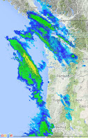
Moving forward in time, at 3:30 AM Langley Hill is showing very heavy rain approaching southwest Washington and that just gets heavier in the 4:30 AM scan. Central and southern Oregon has a strange gap in precipitation, even though the front is, if anything, much stronger there.


Finally, at 6:30 AM, the radar show heavy precipitation from Salem northwards, but an unphysical dry spot to the south.

So if you believed the weather radars, the central and southern coasts of Oregon got hardly much rain. What is the truth? Well, the front has moved through the coast now and we know! Here is the precipitation for the 12 hr ending 10 AM Sunday. The heaviest rain was along the central and southern Oregon coast. You would have never known that from our current coastal radars!

(1) We can not provide skillful short term forecasts of heavy precipitation over the vulnerable coastal mountains, because we can't see it coming.
(2) The lack of Doppler radar coverage at low levels (radars also give Doppler winds), means that meteorologists can not provide good short-term warnings of approaching major storms to the many marine interests along the Oregon coast.
(3) Modern numerical weather prediction systems (like the NOAA HRRR and RAP models) are able to assimilate radar observations (use them to initialize their models), substantially improving short-term forecasts. Unfortunately, the lack of an Oregon coastal radar, makes such forecast enhancement impossible there. And this poor model initialization off the Oregon coast has very negative effects for weather prediction (including wind energy forecasting) over Washington.
Washington State is fortunate to have Senator Maria Cantwell, who championed the acquisition of the Langley Hill radar and who is now pushing for smaller radars over the eastern slopes of the Cascades. Oregon's senators and political leadership need to step up to the plate, pushing for an Oregon coast coastal radar. NOAA and National Weather Service leadership need to work to end this deficiency as well.

Located at roughly 7,000 ft, the lowest radar beams from the Mt. Ashland radar are far too high to sense precipitation coming in off the Pacific,
I would make a stop-gap suggestion. The Medford radar, located at 8,000 ft is nearly useless because of its height and inland location. Move that radar to the coast and put a less expensive radar on Mt. Ashland in its place. This would be a rational and cost-effective plan.
There are also radar gaps over eastern Oregon that could be filled with less expensive radars.


What was the logic at the time for putting a weather radar at 7000 feet? It seems bizarre, they must have had something in mind.
ReplyDeleteThank you. Very interesting stuff in this post. I often times look at the radar online and wonder, why is it raining or snowing when there is no blue or green above where I live? Probably not enough radars inland either, and the info they send is flawed many times. What is the answer though to the problem of weather radar? It is better than without, like in years past, but it needs to improve.
ReplyDeleteIt's funny - I was looking at UW's northwest radar loop last night after midnight because it the sky was clear here (near Sumner), and basically saw your first image without the westernmost blob of clouds and rain. I wasn't considering the radar gap, so seeing just a couple narrow cloud bands with basically nothing over Oregon I thought "why are they saying it's going to rain tonight? There are no clouds to the south of us!"
ReplyDeleteThen of course I woke up to rain and clouds.
This is very true I live in Florence Oregon, and the hole in radar coverage is right over us.Trying to figure out how storms will come in is a real challenge.
ReplyDeleteIs the expense of the radar really concentrated in easily moved electronic components, as opposed to the more permanent structure and large mechanical elements? While having radar sooner is clearly better than later, how much money would be saved by moving an already installed radar, and how much unnecessary money would be spent doing the move? Is it like moving a mobile home, or moving an office building?
ReplyDeleteI don't mean to doubt the idea, but I really have no knowledge of radar costs.
Why isn't a radar located at /near the NOAA Marine Operations Center-Pacific? To my layperson's way of thinking, it seems like a reasonable function to include.
ReplyDeleteThink about..... the flight tracks of radar equipped aircraft over these areas (check out flighttrack24 for example) as well as Rockwell-Collins sites explaining the capabilities of their radars and then what is happening in air to ground data linking. There is great opportunity within those fields of tech to fill the gap and continue to improve the technology faster than fixed stations and at minimal cost.
ReplyDeleteHas anyone thought about old National Guard Radar Site near Coos Bay? How about the FAA Radar site on Laural Mountain? Mt Hebo?
ReplyDeleteLaural Mountain? Hauser Nation Guard (Decommisioned) site?Mt. Hebo?
ReplyDelete