
Take a look at the temperatures above Seattle this morning. The inversion (temperature increasing with height) is incredible. 13C increase between the surface and 500 m (1640 ft). That is 23F increase in 1640 ft!!

Can you imagine taking a hike up one of our foothill peaks? It would be amazing. Cold at the bottom and sweating at the top!
The inversion is so strong because temperatures have warmed up aloft, a very strong offshore pressure gradient developed (producing strong subsidence/compression warming on the western slopes), and cool/foggy air is trapped at low levels. The Space Needle Cam this morning showed the shallow cold/foggy layer very well.

I love the Space Needle Cam and today there was a spectacular optical effect visible...what is known as a glory surrounding the shadow of the top of the Space Needle. You see the rainbow-like circular ring of colors? Sort of like a rainbow halo. That's it.

Glory's are found opposite the sun and result from a combination of reflection, refraction and diffraction of sunlight by a field of cloud droplets of similar size. One sees this effect all the time from airplanes. But not the Space Needle.
Another amazing observation....Paradise on Mt. Rainier got into the lower to mid 60s yesterday and today. Here is the proof:

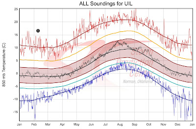
Finally, the warmth above us today is very, very unusual. Here is the plot of this morning's temperature at 850 hPa (about 5000 ft) over Quillayute, WA. The warmest on record for an January, February, or March day!
Northwest Weather Workshop
The big local weather workshop is less than a month away (March 4-5, Seattle). This is the big regional meeting to talk about Northwest weather. If you are interested in attending, the agenda and registration information can be found here.


The halo reminds me of what we used to call Sun Dogs in Montana. What is a sun dog, Cliff?
ReplyDeleteThis website is a fantastic resource for all questions about atmospheric optical phenomenon. http://www.atoptics.co.uk/halo/dogim0.htm
ReplyDeleteVery apparent early this morning. 3 miles north of Monroe at 5:30am out for a run, 35 degrees at home in a sheltered location; 1/2 mile uphill to a clear east exposure, blasting warm breeze. For 4 miles, alternating cold and warm depending on exposure, at times with swirling cold at leg height and warm breeze at head height.
ReplyDeleteBrocken-spectre in Europe!
ReplyDeleteJust after noon today, my car's thermometer said it was 67° at the Anti-Aircraft peak trailhead on Cougar Mountain, elevation 1400'. That was less than an hour after leaving my home on foggy Beacon Hill with a temperature of 45°. As I hiked in the 1200-1500' range, it absolutely felt like mid to upper 60s. An unbelievable contrast in temperatures from sea level to a quarter-mile up.
ReplyDeleteNot a happy condition for us that ski/ride. Lets hope this inversion blows out soon. The ski resorts need a good reset of snow. Good thing there's a substantial base.
ReplyDeleteThis is fascinating, perhaps unprecedented, but is there no reasonable attribution besides Godzilla breathing fire off the NW coast?
ReplyDeleteWe saw a fog-bow yesterday while out on Port Susan. I would like to send a photo but am not sure how.
ReplyDeleteChuck, the pass effect has pretty much kept base temps at Stevens in the 30s. It's been the 40s at the top, due to the inversion. Warm, but not nearly as warm as at similar elevations away from the passes. Great sunny spring skiing the past couple days. Maybe there will be snow on Friday night. The base still doesn't protect from rocks this year, even on groomed slopes. Noteworthy: When setting a short race course on a lower slope this past Sunday, we ran into a very hard layer about a foot down. Hard to drill into it. If it rains in the next few days, it should easily soak through the soft upper snow layer but not through that hard layer. Probably means that rain will create a slippery zone in the pack. Wouldn't want to hit the backcountry under those circumstances.
ReplyDeleteA resort snowpack is not indicative of a backcountry snowpack. Grooming, skier compaction and explosives are not things that generally affect the backcountry snowpack.
DeleteAbsolutely correct, Jason. Didn't say that backcountry would be the same, just that it'd be unsafe if it was. But see NWAC etc for reports this week of hard slab conditions at similar depth in some backcountry areas (eg at Mt Rainier), depending on slope aspect. There's a weather history here.
DeleteThe inversion was very evident on Baldi Mt east of Enumclaw on Tuesday. We were visiting the peak to work on an equipment problem at the radio site. We were able 4x4 to about the 3200 foot level but had to snowshoe the last mile and a half and 800 vertical feet in due to deep snow.
ReplyDeleteThe temp reading in the vehicle was in the low 40's in Sumner after we finished breakfast. Topping the hwy 410 hill in Bonney Lake and escaping the fog it was reading low 50's. By the time we got to 3200 feet and started snowshoeing, it was 65. The breezes on the hike were very odd. You'd get a real warm breeze, 50 feet ahead it would drop at least 10 degrees cooler and then further along it would warm up again. It was warm enough up there to start to smell the fir trees like you can in summer. I had to carry my coat and roll up my long sleeves; I could've done it in shorts!
Here are a couple photos from the hike; feel free to use them in the blog if you'd like, Cliff.
Mt Rainier from the south side of Baldi Mountain:
http://i52.photobucket.com/albums/g13/jackiegrady89/20160209_145603.jpg
The Olympics, Puget Sound, Seattle and Tacoma in the background, myself in the foreground:
http://i52.photobucket.com/albums/g13/jackiegrady89/12670042_10208691477104245_6145673613584952897_n.jpg
In case anybody is interested, recent snow pack information. http://www.wcc.nrcs.usda.gov/webmap/index.html#elements=&networks=SNTL&states=WA&counties=!&hucs=&minElevation=&maxElevation=&elementSelectType=all&activeOnly=true&hucLabels=false&stationLabels=&overlays=&hucOverlays=&mode=data&openSections=elements,location,labels&controlsOpen=true&popup=&base=esriNgwm&dataElement=WTEQ¶meter=PCTMED&frequency=DAILY&duration=I&customDuration=&dayPart=E&year=2016&month=2&day=10&monthPart=E&lat=46.969&lon=-120.119&zoom=8
ReplyDeleteSorry don't know how to shorten the link, just copy and paste. Not as good as it was a month ago. Some places are still running well ahead, others are below, and others are near normal. It was a blessing in disguise to get pounded so hard from mid November to mid January. While the water situation is miles better than last winter, I don't personally believe the drought situation is 100% fixed. If the winter goes La Nina late this year, that could solve the drought situation for quite some time. However, with more precipitation coming, there is still time for the state reservoirs to pick up a lot more water.
Southern California might be screwed. If you see the latest from NOAA for the 10-14 day period (This is NOAA, take with a grain of salt), it is supposed to be very dry in California, and we are supposed to drop back to normal, from the current call for above average precipitation. http://www.cpc.ncep.noaa.gov/products/predictions/814day/814day.02.gif
Last note...this is the most bizarre winter I have ever witnessed.
I would think last winter would win the "most bizarre" award.
ReplyDeleteChuck: About bizarre. It depends on where you live. I agree that 14-15 was bizarre because of how dry it was. But this year has had more stuff in one winter than I ever remember. Massive windstorms, big rainstorms, big snowstorms, some extreme cold here, dry spells and now a lot more rain incoming. Very weird.
ReplyDeleteI encourage you ( Cliff Mass ) to read up on Scott Stevens website...http://weatherwars.info. Take Care
ReplyDelete