_______________________
As we approach the weekend, it is becoming increasingly clear that a major cold/snow event will occur next week, but with substantial uncertainty about lowland snow. One thing is certain: it will be an extraordinary week for snow in the mountains, and everyone who enjoys mountain snow recreation should get ready for a wonderful period of light, bountiful snow.
Right now the snowpack is still a bit below normal over about half of the region, with near normal snowpack (green colors below) and crazy above-normal snowpack in a few areas (the Olympics are over 250% of normal!) By the end of next week the entire mountain region should be above normal.

Early next week will be the coldest period since last January, with temperatures dropping into the 20s over western Washington..... so drain you hoses and protect vulnerable plants.
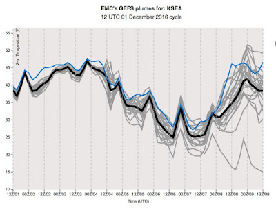
The models, both high-resolution and ensembles, are in agreement that we will have a much colder period early next week. The NWS GEFS ensemble system (21 members in gray, ensemble average black, GFS high-resolution member-blue), show unanimity of solution towards colder temperatures in Seattle early next week (highs in mid-30s, lows in the mid-20s), with modest warming at the end of the week (see plot below)

During the next week, the cold and snow will occur in roughly three acts. The first act, as shown by the low-level temperatures (colors), winds, and sea level pressure at 4 AM Sunday, will encompass a strong cold front that will move southward across our region in Sunday, bringing much colder air (see below). By later on Sunday, the air above our region will be cold enough for snow to reach near sea level.

In the second act, which will take place on Monday, cold air will extend over Washington and Oregon with frigid conditions to the east of the crest of the Rockies. A low center will form over western Washington (map at 4 PM Monday shown below). How the low develops and positions itself will determine how much snow falls in the lowlands.

In the third, and perhaps the most dramatic act, a weak occluded system approaches the coast bringing warming temperatures aloft and precipitation. With cold air in place over western Washington, the precipitation will start as snow at low levels, and perhaps a lot of snow.

Now lets look at the ensemble snow forecasts. The NOAA/NWS GEFS ensemble show a lot of variability (and thus uncertainty) with the forecast, with the average of all the forecasts (black line) and the high-resolution forecast (blue line) looking very similar. There are a few inches on Monday, a gap, and then a lot more snow later Wednesday and Thursday. All the models show at least 3 inches by the end of the period.

The European Center ensemble shows a similar picture: light snow Sunday/Monday, but heavier amounts Wednesday/Thursday.

Now, to see the spatial distribution better, lets turn to ONE forecast, the UW high-resolution prediction based on the NOAA/NWS global model. For the 24-h period ending 4 PM Monday (below), there is plenty of snow over the region, some of which extends to ground level over Puget Sound an SW Washington.


So at this point, much colder temperatures is virtually guaranteed Monday through Wednesday, and there is consensus among the ensembles that we will get at least some light snow at low levels. The warm road temperatures will help to mitigate the impacts on highways in contact with the soil.


Please let this materialize. I would love some lowland snow.
ReplyDeleteI am completely on board w/ you... definitely one of the most exciting weather events Western Washington has to offer...And hands down the most amazing/ fun/ beautiful in this area. To me SNOW is th he most exciting thing on the forecast!;)
DeleteDefinitely the highlight of the year for my weather excitement! Ever since I can remember, the dreaded for letter word, SNOW has brought me the greatest excitement... Though challenging it is always the funnest to hypothesize- how much will we get here... I love it- no weather event brings more beauty and fun to this already beautiful place we call home than a nice white blanket of snow... let it snow- let it snoe- let it snow;)
DeleteAlright Cliff, you and I both know that the Wednesday/Thursday situation as it has appeared the last several runs is a Kitsap/Hood Canal beauty in the making. We are due for a nice, decent snow.
ReplyDeleteBRING IT ON.
I'm rather skeptical,especially regarding the predicted temps.I don't see the upper level heights dropping much below 530 hPa for the entire period.I don't see how it can become as cold as some of those models predict,unless there's a 15MB Williams Lake to Bellingham Fraser arctic air outflow gradient coming that I don't know about.Also the latest 00Z GFS/ECWFM models seem to be trending toward a progressively warmer wx pattern,as an offshore high noses in.My hunch is that if it snows,it's going to be the wet,heavy type like Nov'96 or Dec'74.I seriously doubt that there will be enough cold air in place to facilitate a major overrunning snow event later next week.
ReplyDeleteCliff,
ReplyDeleteI had a conversation with a friend to the effect of "we haven't had real snow in years". By "real snow" I meant the kind that keeps me home rather than driving my sports sedan to work in Redmond. Certainly at least two inches? My unscientific Facebook search tells me the last time that happened was January 17, 2012, nearly five years ago. I'm wondering if there's a better way to know though. Is there a place where the general public can access this kind of record? Where would you go to walk down memory lane?
Thanks,
David in Redmond
David:Historical data,some dating as far back as from the late 1800's,from the Local Climatological Data publication is available free to print on your home computer through the National Climatic Data Center (NCDC).Data for places like Seattle,Olympia,Portland,Yakima and Spokane can be accessed there.Also,more recent data is available to peruse through your local NWS website.Just click on the Climate section,and go to the archived monthly data.
DeleteDavid,
ReplyDeleteI use Climate Data Online from NOAA to get historical data: https://www.ncdc.noaa.gov/cdo-web/. It's not the most user-friendly interface, but you pick a location/station, a date range, and the data elements you want, then submit a request. It can take anywhere from 10 minutes to a few hours, but you'll get an email when your data is ready.
Not only does the worthless GFS model over predict cold air intrusion it still shows 925mb temps 0 to -2C. Since when does that temperature cause lowland snow. That's the line I like to look at for snow at Snoqualmie Pass. The useless map out of the GFS is the accumulated snowfall. Last night run showed a solid 12 inches at Mt Baker, several inches all passes today. Can't even get 12hrs ahead right.
ReplyDeleteCliff: is there a way to access the graphical maps you use on this blog for predicted temps/snow amounts on the web somewhere? Or are those produced by you or someone else privately? Thanks for the great blog!
ReplyDeleteWould love for you to do a write up on what the potential impact of the "cold blob" will be, or if in fact it is even true.
ReplyDeletehttps://wattsupwiththat.com/2016/11/30/the-blob-in-the-pacific-turns-from-warm-to-cold-and-its-even-bigger/
Also any thoughts you have on the longer term forecast referenced here and it impact on the coming week:
https://wattsupwiththat.com/2016/12/01/noaa-forecasts-major-december-cold-blast-for-nearly-all-the-usa/
Thank you!
rdp--
ReplyDeleteHis maps for the GFS are here,
https://www.atmos.washington.edu/mm5rt/
has for different resolutions (1 1/3 to 36 km). Also has NAM run. It's a really good resource.
I think the ECMWF is from weatherbell.com, you can get a free trial but it's like $20/month. I have yet to find a free, user friendly output of the ECMWF for western Washington.
Have always loved your forecasts. Why the NWS has blown the wind forecast (again) this evening has me wondering how talented our forecasters are in the Seattle office. Haner is a vet, and a few others, but are we letting rookies forecast the Sound? It's howling out there. Fisherman in the derby up north are saying it's blowing near 50. Why is the marine forecast blown so many times? The Edmonds/Kingston run is showing sustained S40G50 right now and this is the forecast for right now...PZZ135-030800-
ReplyDeletePUGET SOUND AND HOOD CANAL-
259 PM PST FRI DEC 2 2016
SMALL CRAFT ADVISORY IN EFFECT UNTIL 6 PM PST THIS EVENING
TONIGHT
S WIND 15 TO 25 KT EARLY EASING TO 10 TO 20 KT DURING
THE EVENING. WIND WAVES 2 TO 4 FT. A CHANCE OF SHOWERS.
Why is this such a common occurrence? Especially for us who love to fish the Sound.
One of the issues with marine forecasts in PNW waters is that geography can greatly accelerate winds over small areas. West Point off Seattle is a classic case, as are Race Rocks near Victoria. Many other places to a lesser degree. Forecasts reflect the more open water.
ReplyDeleteWhen I was a serious cruiser, traveling back and forth multiple times to Alaska and living year-round on the Strait and in the San Juans on my boat, I always added another 50% to the forecast for steady winds (75% for gusts) when rounding a point of land. Unlike the current tables for passes/rapids, which can be predicted with more accuracy based on tides, the wind forecast is always going to vary greatly based on location and time.
Notably, an hour after you posted, the Edmonds run (along with the rest of the area) was back under forecast winds.
The trick for safe boating in this area to make sure you can easily weather conditions that are half again as strong as forecasted. And with difficulty, you can handle twice the forecast without losing the boat.
(Although I do remember an anchorage in Northern BC where the predicted 25knot winds turned into something that pinned my anenometer needle hard against its maximum 60knot stop pin. That was a sleepless night. Thankfully I'd dropped a cartoonishly oversized anchor -- the only kind to carry to Alaska. If you think forecasts are iffy down here, it's way worse from North BC through SE Alaska.)
Dr. Mass,
ReplyDeleteWhat impact will this have for transportation, the roadways, and bus service (alternate routing?).
Cheers,
Bert
My definition of a real winter storm, expanding on what David suggested:
ReplyDelete2 days when driving is difficult because of snow
School closed for two day
Unprotected pipes and crawl space in danger of freezing
Sledding for at least two days
At least two day when daytime highs are around 25 degrees F
Fifteen years ago I might have added I could once again go ice-skating on Kitsap Lake, but that has not happened for decades. Anyone remember the last time?
Can we say the drought is over and start having sprinkler fights again?
ReplyDelete