A few days earlier the air was over the tropics. Moist, warm and soothing to our wind and cold whipped skin. And we just broke a major low temperature record. This morning, our low temperature (56F) was the HIGHEST low temperature ever recorded in November at Seattle Tacoma Airport. That is a big record to break.
Yesterday, Bellingham broke their daily high temperature record (60F) and today all sorts of daily high temperature records will be broken around the region.

To certify the tropical origins of our air, I used the NOAA Hysplit trajectory model to trace the origin of the air above us at 500 meters (blue), 1500 meters (red), and 3000 meters (green) for the past 150 hours. Our low level air, came from just east of Hawaii. The 1500 meter air from the deep tropics. No wonder many of us are fighting the urge to grab a Mai Tai today.

A plot of the winds and temperatures above Seattle for the past day (below), shows a freezing level of 10,000 feet, with strong southwesterly winds aloft--a sign of a potent atmospheric river event.

Over the past 24 hr (ending 5 AM), portions of the SW slopes of the Olympics received over 6 inches of rain, with the north Cascades getting as much as 3-5 inches.

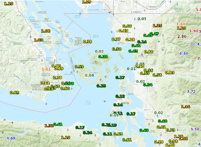
But perhaps more impressive than the rain on the windward sides of the mountains, is the profound rain shadowing in the lee of the Olympics, where some locations only received 1-2 hundredths of an inch (see below). Just amazing.
However, the wacky weather award yesterday had to go to Bellingham, Washington, where in less than an hour (around 4 PM Tuesday), the winds turned southerly and surged to over 40 knots, and the temperature rose from 46 to 60F (see report below).

The temperature trace there shows the story and the fact the temperatures are EVEN WARMER right now--62F (and there are strong winds at Bellingham currently as well).

Perhaps just as unusual was the existence of sea fog (a.k.a., warm advection fog) over Lake Washington this morning (see below). The air was so humid and warm (dew point at Seattle-Tacoma Airport was 57F at 7 AM), that the cooler waters of Lake Washington (51F according to the Lake WA buoy) was able to bring the air to saturation.

The temperatures today will delight you. A plot of temperatures during the past two weeks at Seattle shows that our current morning temperatures are WAY higher than the normal highs (purple line below).


That might explain why when my 15 year old son wanted to drive to the store and we were heading due south, all of sudden, the windsheild fogged over. We thought it was inside the car for a moment, then I said try the wipers. We cleared off an amazing amount of moisture. This was around 4pm in Bellingham.
ReplyDeleteJust remember that the Sea-Tac temperature has to stay at or above 56 all the way through midnight tonight for the record minimum to officially go in the books.
ReplyDeleteWhat's even wackier up here in Whatcom County is the comparison between Bellingham and Lynden, just up the road. We didn't experience Tuesday's afternoon temperature spike. Currently (Wednesday at 10am) it's 63 in Bham and 48 in Lynden. So it goes with microclimates!
ReplyDeleteIn the three to four PM temp change in Bellingham yesterday, all the windows in the house fogged up on the outside, much like the other posters car windows. Very strange weather, 66 and sunny right now with the top down on the converetible.
ReplyDeleteHad some river fog down here on the Willamette as well. Very odd to see. The warm humid air feels great.
ReplyDeleteI was walking home from class at 3:50 yesterday and it was like swimming through different currents in a lake. One moment the wind is a biting chill and then the next moment it’s like sitting in a bath tub. And it went back and forth the whole ride home. So bizarre!
ReplyDeleteMy personal weather station on South Hill (Puyallup) currently reads 71 degrees.
ReplyDeleteWell there goes the nice snowpack Crystal Mountain had. Very unfortunate. Seems like they won't get that base back until later mid-to-late December. Given the good base they had on Sunday, this prolonged rain and warm temperatures have done nothing but ruin the Northwest ski season and turn the snowpack to a mudpack.
ReplyDeleteI'm watching all the hornets and other bugs flying around outside the window. They probably think it's spring!
ReplyDeleteMy car thermometer said 72 in Auburn. I know car thermometer readings are suspect but it felt every bit that warm.
ReplyDeleteAt least for a day I got to feel that pleasant, breezy Hawaiian air.
ReplyDeleteWHAT HAPPENED TO LA NINA?!?!?!?!?!??!!?!?????
ReplyDeleteUW Atmos rooftop sensors are not reporting wind gust/speed as of Nov 23 00:00 UTC at https://atmos.washington.edu/cgi-bin/latest_uw.cgi (well, I suspect a very low probability they have been 0kt except for two minutes in the last 17hr).
ReplyDelete