As many of you know, a coastal radar has been a dream of Northwest meteorologists for a long time, a device that will improve warnings and forecasts, improve our quality of life, and save lives and property. The acquisition of the radar wasn't going anywhere until Senator Maria Cantwell, reacting to the public concerns about the major storms of 2007, worked to secure the necessary funding (9 million dollars in total) last year. Intense interest by the public, the media, and local business and environmental groups also helped. The National Weather Service is now solidly on board with this acquisition, with enthusiastic support from local offices and NWS Western Region.
Using some initial funding from the Stimulus Bill, the National Weather Service hired an experienced firm, SRI International, to do comprehensive site surveys. At the same time, the University of Washington ( specifically Dr. Socorro Medina, with consulting from Professor Houze and myself) took advantage of sophisticated radar simulation software to look for excellent sites. These sites were passed to SRI, who investigate many of them. A good site had to have:
1. A clear view out to the ocean, including the entrances to the Strait and Columbia Gorge.
2. Good views towards the Olympics and SW Washington to see the precipitation on their windward slopes.
3. Good views over the coastal zone.
4. Heavy duty three-phased power nearby, plus a high-bandwidth communications line.
5. A lack of nearby obstacles and no electromagnetic interference.
6. Accessibility over a reasonable road.
7. And more (e.g., nearby good coffee)
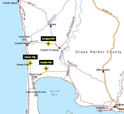
After a great deal of discussion, three potential sites were identified, with the one of choice being Langley Hill (see map below). Two runner up sites were Ocean City and Saddle Hill (also on the map)

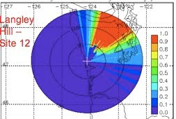
Here is the simulation of what the radar would see for a low scanning angle--.5 degrees.
(Some radar 101: the radar scans in azimuth (0 to 360) at a certain elevation angle above the horizontal. Typically the lowest angle used by the NWS is .5 degrees, but virtually all meteorologists in our area want this radar to start at 0 degrees...to see farther out).
This is GREAT coverage: beautiful view offshore. Olympics cause blocking...but that is fine--we can see the rain on the wet SW slopes and the Camano Island radar can see the other side.

The full report (see below) has lots of pictures and information on the site. Power and communication is only 500 ft away and it is on top of hill owned by a local timber company. Not sure about the coffee. I should note that once operational the radar will be unmanned.
If by some chance the NWS can't acquire that site, we have other viable choices.
If you would like to read the full report, it is found at:
http://www.atmos.washington.edu/~cliff/Radarsiting.pdf
You can also find a copy at the Seattle NWS web site.
The next stop will be deciding on the radar specifications, ordering the unit, and deciding on its scanning strategy. There are some issues regarding this right now, with the UW and local NWS meteorologists wanting to optimize the scanning approach for our needs, while some radar NWS HQ types wanting the unit to work like the rest. But more on this later. But whatever happens we will have a marvelous piece of hardware: state of the art, high powered, dual polarization (which the rest of the country doesn't have yet) and more.


Great news, but can you comment on why the site selection information "has been under wraps for a while?"
ReplyDeleteWhy under wraps? Because the National Weather Service wanted to do it that way until all the information was finalized and vetted. How does one explain large government bureaucracies? That goes on someone else's blog....cliff
ReplyDeletePaste these two numbers into google maps if you want to see a detailed satellite view of the proposed site:
ReplyDelete47.1168, -124.1063
This was probably touched on at PNWW last week but were locations south of Grays Harbor considered? And if so, why are they not "finalists"?
ReplyDeleteThis is so gratifying to see and read. I've been following your blog for over 2 years and this is just such terrific news. Congrats for being a part of making it happen!
ReplyDeleteThose specs sound great. Hopefully now when we see a storm coming, that radar installation can divert the storm south to Portland, and make sure we have nice weather for Mariners home games.
ReplyDeleteNice job, I can't wait!
I read the report and found no background information about historically winds and seismic events at these sites. Will the radar and support equipment be designed to withstand 200 MPH winds and a typical 300 year subduction zone earthquake of 9.0?
ReplyDeleteHow long until it's up and running ?
ReplyDeleteCongrats to you Cliff and your collegues for pressing this needed radar forward
ReplyDeleteHowever this works, I just hope that once it's up and running, the precipitation coming in over the Olympics will appear seamless from the coast to the western WA interior when I access the radar from my various Internet websites and mobile applications.
ReplyDeleteHow about UPDATING this site AT LEAST every other day, huh?
ReplyDelete