The bottom line is that my ability and the ability of my colleagues are very limited in such predictions---even though seasonal forecasts are made by the National Weather Service.
Weather forecasting skill, the ability to predict the specific weather situation, fades out between five and ten days into the future. Numerical and theoretical studies demonstrate that we are unlikely to have forecast skill of specific weather features beyond 14 days. So don't believe the Farmer's Almanac.
But it is possible to have limited prediction skill beyond two weeks for the average conditions in the future, such as whether an upcoming season will have temperatures above or below normal.
The National Weather Service's Climate Prediction Center provides monthly and seasonal forecasts of the mean or statistical properties of the atmosphere. Their most important tool is the correlation of U.S. weather with El Nino/La Nina with midlatitude weather conditions. They have others: current soil moisture and snow distributions, the current and predicted states of other major atmosphere or ocean variations (e.g., the Pacific Decadal Oscillation, and Arctic oscillation, etc), and other parameters. Their predictions really don't verify that well, but have marginal skill.
I should note that El Nino/La Nina correlate fairly well with our winter weather (as shown by the low snowpack during this El Nino year), but it has minimal value for predicting summer weather.
So here is their latest NWS forecast graphics for temperature and precipitation for June, July, an August:


Their call: warmer than normal and drier than normal. Basically persistence.
But quite frankly, I would not bet the farm on such predictions, their skill is marginal.
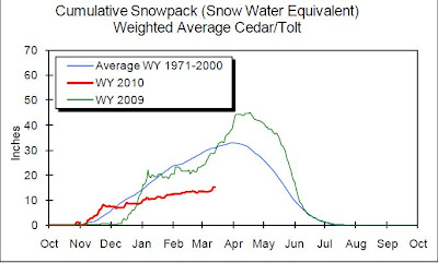
But there some things we do know. As shown in the map below, our snowpack is well below normal--roughly 65% of typical values at this time of the year.
 Not a disaster, but low. Looking at the weather models for the upcoming week, you cannot expect us to get anything significant during the next five days.
This is enough snowpack to insure plenty of drinking water this summer, and in fact because of smart management and nearly normal winter precipitation (much of it rain), the water in Seattle reservoirs are above normal (see graphics).


It does look like agricultural and fish will suffer from below normal snowmelt this spring and summer. But you never know....


I see you are answering the question Steve Scher posed on KUOW's Weekday on Friday at 0955.
ReplyDeleteOne question: how marginal is the skill of the climate forecasters? What fraction of the time do they "get it right" (for some appropriate definition o "getting it right"). 55%? 60%? 65%? Better than that?
Or is it more along the lines of El Niño ~= warmer, drier?
Very interesting. Thanks for showing us that.
ReplyDeleteIt looks as if they expect a stronger intermountain high, and a trough sliding down the central US and swinging back up the east coast.
Stronger Mt. West high could reduce marine influences and open the door for southern dry convection, maybe. Might be a bad fire season.
just no more 114 degree days
ReplyDeleteAbout the snowpack:
ReplyDelete65% of average for the Cascades... But why does Whistler will have the 3rd most snow for a season since records were kept there? And November set an all time record for monthly snowfall.
I like the hot weather
ReplyDelete