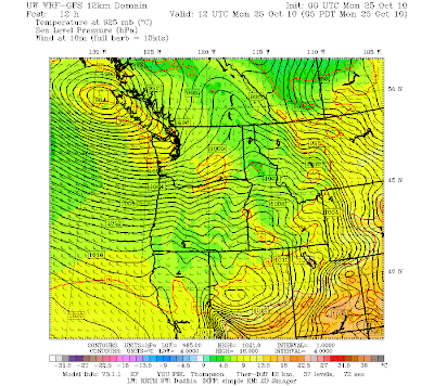

This is really turning into an extraordinary event. I can't remember over many years seeing this situation...a very deep system, slowly dying, that is sitting right off our coast for days. The models are having a very hard time with this storm as well.
Today a batch of very unstable air rotated around the low, bring lines of strong convection with heavy rain. With the low sitting out there and the strong winds remaining over the offshore waters, the waves have gotten huge. To show this, here are the significant wave heights (average of the top 1/3) for Buoy 46005, located at 130W off our coast. Update 8 AM Monday....40-45 feet!

Here are the sea level pressure forecasts starting at 5 PM tonight through 5 PM tomorrow. As the low moves eastward, the north-south pressure differences will increase and the winds over Puget Sound should crank up. And big waves will be striking our coast--right now they are 25-30 feet and they will get higher.
Here is a great web site showing coastal cams and providing a wonderful interface to buoy and coastal reports:
http://www.surfwa.org/Surf-Report-WA-OR-BC.html


And finally the rain. A few of you complained that the rain was a disappointment. But check out the 48-h rainfall total from Seattle rainwatch below. A band of 1-2 inches across the Sound with some places near the Olympics getting 3-4 inches. An an amazing rain shadow NW of the Olympics...nearly dry there. Want HUGE rainfall...head to northern CA...bet that will be on the news tomorrow.


How on Earth could anyone be bored being a meteorologist (well, with the exception of possibly summer)? What a fascinating occupation. A job where you actually look forward coming into work.
ReplyDeleteI always enjoy reading your blogs, Cliff!
We drove to Westport yesterday (from Seattle) just to see the wave action. Large (20'+) waves breaking over the marina jetty at 2 pm high tide and seawater running down the main street. Lots of worried City and Corps folks out watching the water run down the street; scary to imagine another 8 - 10 ' of wave height today.
ReplyDeleteHere are some cams of the Columbia Bar. The waves don't look to impressive but the camera is mounted on the North Head lighthouse. The Benson beach cams shows the jetty and the Columbia Bar in the horizon.
ReplyDeletehttp://www.planetargus.com/north_head/
In order to argue for the benefits of coastal radar, I would love to be able to tell people how the presence of coastal radar would have changed the prediction and/or response to this past weekend's storm. Would love it if Cliff (or anyone else) could provide that. Would be a good election-season selling point for the benefits of earmarks.
ReplyDeleteI was working between Quilcene and Port Townsend, Dry all dat and even a fair bit of sun.
ReplyDeleteCliff ~ The NWS is talking about another "active" pattern after Wednesday....What do you think about this and how active might it be? Also...why are they saying it might be windy in the East Puget Sound Lowlands on Wednesday? That's my zone.
ReplyDeleteI am guessing there will be high pressure over eastern washington on Wednesday with lower pressure off the coast causing a pressure difference. It is about the time of year when we start getting our breezy to windy days in the foothills.
ReplyDeleteNo mention of the fact we have not yet had a hard frost? I don't recall an October when the last week of the month has had so little in the way of fall color.
ReplyDeleteHmmm. I think that NOAA buoy data is flawed!!! (AND HAS BEEN AWHILE) That late Oct. swell report of 35' to 40' wasn't even 1/2 that! We went to Neah Bay (surfing) and got skunked. 3 days in a row! Searched the whole coast. It's like someone is having fun watching surfboards head west!
ReplyDelete