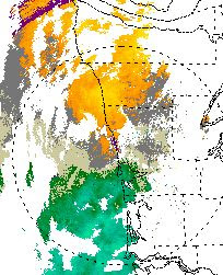
Today modern radars paint out a wonderfully nuanced image of such echos, most of which are associated with huge supercell convective storms:
This image is from a intense storm over Oklahoma.
So why I am bringing this up now? On Thursday, I received an email from a Canadian forecaster who was excited to see a well-defined hook echo along the Washington coast (viewed by my favorite new radar, Langley Hill). Here is an example (the times was between 10 and 11 AM on Thursday, 1800-1900 UTC)
You can see the well-defined hook just offshore south of Quillayute (UIL). So was there a supercell storm and tornadoes/hail off the WA coast, or was there some other explanation of this amazing image? We are fortunate that this feature was extremely well positioned to be seen by the Langley radar. Ok, lets play detective!
First, one would expect very high reflectivities (intense radar echoes) and some rotation (called a mesocyclone) as viewed by the doppler capability of the radar. Here is what the radar showed. First, the reflectivity:
The radial velocities (towards or away from the radar) are next.
Mesocyclones (regions of rotation with supercell storms) generally show couplets of velocities towards or away from radar--that shows rotation. Looks like this:
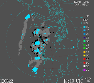
No hint of that pattern here. Strike 2. Furthermore, supercell storms generally have high tops. Here is the top of the radar echos for this feature:
5-10 thousand feet. VERY unimpressive. Big storms in the Midwest can get to 50-60K feet and supercells around here up to 25-30K ft. Strike 3.
So when we look under the hood, it does not appear that this is a supercell storm. So why the hook echo?
We had a nice line of heavy showers approaching the coast relatively slowly. If there was enough horizontal wind shear, that could roll up the convective shower line into such hooked features. In fact, if you look at the first image above, there are hints of other rolled-up echoes. The Doppler velocity figure suggests that there was some shear at low levels offshore. There are some very limited surface wind observations that indicate the same thing:
 |
| Observation at 10 AM |
Moderate southeasterlies at Destruction Is and southerlies offshore. Put a pinwheel in there at the right spot and it would tend to rotate. I suspect that is what happened... the tendency for rotation in the winds (we call it vorticity in the biz)..caused a roll-up of the convective shower line. A fun oddity, but no big storm along the coast (if any of you were out there then, let us know what it was like!)
PS: the western weather satellite is repaired and back online! And mild weather is ahead.


If rotation wasn't showing up in any velocity, it likely wasn't rotating at all. My guess is that if you looped it was probably just a shower moving into another shower or something like that. No need to pinwheel - it's probably just the way one scan looked.
ReplyDeletewhat about low topped supercells? and shouldnt you be looking at SRM not Base vel?
ReplyDelete"and shouldnt you be looking at SRM not Base vel?"
ReplyDeleteYou can see there is no rotation in the base velocity plot.
Look at the position of the "hook" feature. It's all the same color all through that area so it's all the same velocity. If there was rotation you'd see different colors there corresponding to the radial component of the rotation seen by the radar.
Storm relative motion (SRM) subtracts the storm motion vector from the wind radial velocity vector seen by the radar. It works well when the system correctly figures out how the storm is moving. Then the velocity offsetmakes it easier to find the cold/warm color couplet at a glance. Useful in the mid-West (when you spend a lot of time looking for hooks) but not so much in this case.
SRM plots are a convenience not a requirement.
It is Saturday night, almost 9pm, and I just learned something really neat about weather and weather detection. I will never forget the term "hook echo", and what it might mean, or, upon closer investigation, not mean.
ReplyDeleteThank you, Professor Mass!
40 years ago, as a kid in the deep south, the term Hook Echo was one of the scariest things we knew. When you heard that from the radio or an adult, you ran for cover. I don't think i've heard the term in decades, but when i opened the blog this morning and saw Hook Echo, i froze!
ReplyDelete