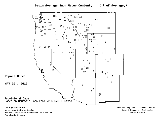
But we have a really good snow pack and lots of water for this summer. Here is the latest snow pack in terms of percentage of normal. Most of Washington State is well above 100%--much of it above 150%. Northern Idaho and western Montana is in decent shape too. But the situation to our south is very poor...15-20% in the central Sierra, and in the teens and single digits in Utah and Colorado. The Colorado River will be running real low this year.
According to the State of California, total water content in the Sierra snow pack was measured at 40 percent of normal. It was 190 percent of normal this time last year.
And that is why California will get by this year...they had such a huge snow pack last year they were able store enough water for a second year in the reservoirs.
Spring snow melt brings up the levels of Northwest rivers, particularly east of the Cascade crest, and this sometimes causes flooding. Here is the latest river level information from the Northwest River Forecast Center in Portland.
No floods right now, but several eastern Washington and northern Idaho rivers are at or above bankfull (orange colors)--this is from snowmelt. Many of these rivers were even higher a week ago when we had the warm weather that caused intense melting. To illustrate, take a look at the flow on the Okanogan River near Tonasket (see below)--they even reached flood stage (red line)
Our future? Well, the next 48-h should bring more showers (see 48h precipitation forecast below), but we should dry out on Friday and for the weekend. The jet stream moves south of us, taking the wet stuff south to those poor dry devils in California. They need the water to fill their hot tubs and water their illicit crops in the hills.


I think you should add wind power versus hydro forecasts to your snow pack posts. Last year the wind farms were shut down during the spring run-off, right? I've heard salmon advocates were pushing to do the reverse and use the extra water for spilling water to help salmon.
ReplyDeleteYou are a funny, funny weather don.
ReplyDeleteHi Dr. Mass,
ReplyDeleteI have a question about convergence zone winds.
Like you, I ride my bike to/from work...Woodinville to Bellevue and back.
Last night (5/23) at around 5:00pm riding north on the Sammamish River Trail, I was enjoying a delicious tailwind that had me cruising at 22MPH without pedaling hard at all. When I made it to the vicinity of the Redhook Brewery, in a distance of about 1/4 mile, I not only lost the tailwind but found myself pounding into a headwind that made it difficult to ride more than 15MPH!
At the same time, the sunshine I was riding in was gone, replaced by low dark clouds and rain.
Could this have been the transition zone between the north and south convergence zone winds? Looking at the radar images from around that time, I see what looks like a convergence zone forming, but the transition from tailwind to headwind was so abrupt that I wonder if maybe it was just a local topography phenomenon?
Thanks in advance if you get a chance to answer this question. I enjoy the heck out of your Blog and appreciate the effort you put into it.
Regards,
Brian