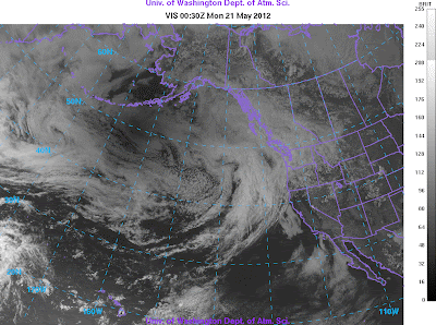
It was cloudy over most of the Northwest and thus we were unable to see the annular solar eclipse from the ground...disappointing! But if you can't see it from the ground, why not enjoy the view from space?
Can you see the eclipse from one of the National Weather Service (NWS) weather satellites? You bet you can.
Let me show you a sequence of visible satellite images from the NWS GOES-West geostationary satellite, orbiting approximately 35,000 km above the planet. Below you will see a series of these images, starting 3 PM (2200 Z--zulu time or GMT)-- before any lunar shadow was evident. Note the area of darkness--the lunar shadow-- that moves in starting 4 PM (2300 Z). The dark splotch approaches and crosses the West Coast. By the last image (7:30 PM), most of the darkness has cleared the western U.S. Scroll down quickly to get the effect.
Pretty neat. If you want to see a satellite loop...check this.
One place in western Washington that did get partial view was in Sequim, where the downsloping flow thinned the clouds (the ensemble prediction in the previous blog suggested this). Here is a view by Seattle PI photographer Joshua Trujillo (his article found here).
 |
| Sequim View by Joshua Trujillo |
If you want to see more views from the ground there a number of videos on youtube . A sample: http://www.youtube.com/watch?v=uFcwAPFMM-k


We saw it here under the Sequim hole and have the photos to prove it.
ReplyDeleteCIMSS also posted an animation:
ReplyDeletehttp://cimss.ssec.wisc.edu/goes/blog/archives/10404
Tri-Cities: missed it. Clouds rolled in and got thick at just the wrong time. Brutal that Sequim has downsloping bragging rights over us in the mid-Columbia.
ReplyDeleteIn Portland (North Portland anyway) we lucked out, the clouds thinned just perfectly from about 6:20 to 6:45 PM. A pleasant surprise, given the forecast and the otherwise general overcast.
ReplyDelete