To illustrate, take a look at the sea level pressure forecast for tomorrow (Wednesday) at 10 AM. An amazing large and intense low pressure area over the Pacific. In fact, it appears to cover virtually the entire NE Pacific!
This offshore pressure gradient will get an added boast as a weak low pressure disturbance, embedded in this giant low rotates around near us. There are several places that will get a good blow from this: offshore over the eastern Pacific, along the western WA foothills (hello Enumclaw, Black Diamond, and North Bend), and along the western portions of the Strait of Juan de Fuca. And later in the event NW Washington get strong winds. Lets look at the last WRF surface sustained (not gust) winds for the next day. First, 4 AM tomorrow (Wed). 20 kt sustained in the foothills (some folks will get gust to 40), and accelerating winds in the Strait, with sustained 25+ kt near Tatoosh Island. This is not a good set up for extensive, strong winds in the foothills--the wind are not easterly aloft at crest level.
By 4 PM tomorrow, 30+ kt over the western Strait and similar winds northeast of the Olympics. Those poor, sunburned folks in Sequim will get now be getting some wind burns as well. Too windy for golf.
The western Strait can be very windy during such offshore flow, with air accelerating towards the west. Strong winds, lots of rocks, and often clouds/fog make this region very dangerous for marine traffic, and, in fact, there have been numerous shipwrecks there, giving it the appellation of "Graveyard of the Pacific." During the days of sail (1830-1925) there were 137 major shipwrecks in the immediate vicinity of the entrance to the Strait. A major and tragic example is the 1906 shipwreck of the Valencia, with the loss of nearly 150 lives (see graphic).
 |
| The Valencia |
Rain returns tomorrow afternoon, but with this large low over the NE Pacific, most of the flow will go south of us into southern Oregon and northern CA. Here is the forecast precipitation for the 72 hr ending Saturday at 4 AM. Huge amounts over northern CA.
Snow? We will have relatively warm, southwesterly flow so Snoqualmie is out of luck. Very marginal for Stevens. Want snow? You will have to go to Baker, Crystal, and Whistler.
Update Wed AM
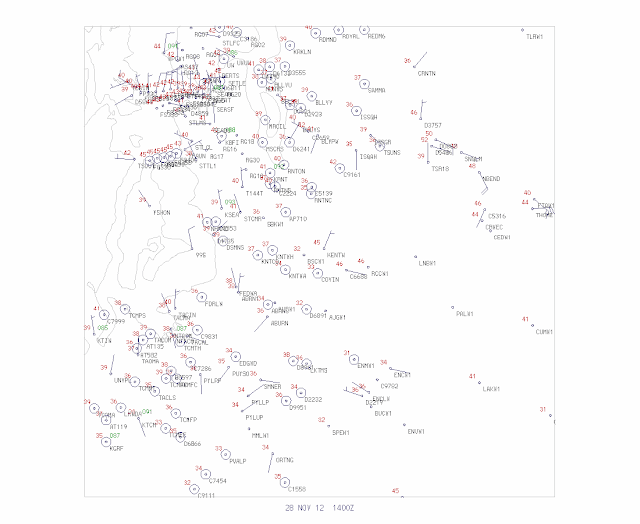
Easterly flow in the foothills can produce large temperature variations. While many locations cooled into the 30s last night, those areas experiencing easterly (downslope) flow are in the upper 40s and even lower 50s. Here are temps at 6 AM this morning...look carefully and you will see this big contrasts over the eastern part of the terrain (the map extends from Seattle to North Bend)::


At 11:45 PM the area 6 miles East of North Bend is experiencing sustained winds at 26 mph with gusts to 40 mph. It's been slowly building all evening. From the forecast I'd expect to see gusts to 50 mph by morning.
ReplyDeleteCliff, Baker is actually quite low in elevation - their base is lower than Stevens'. I've often wondered if their precipitation pattern is due to convergence behind the Olympic shadow.
ReplyDeleteFloyd...you are right..I just checked...the elevations are really comparaable.but Baker gets much more snow because it gets a lot more precipitation due to the regional terrain...cliff
ReplyDeleteHmmmm...I was looking at the GFS model and...I know long range is not very accurate...but it looks like it's going to get cold...with moisture? Could we possibly be looking at a chance of snow if the GFS is correct and sticks with its prediction?
ReplyDeleteA popular nomenclature quibble, Professor. The Columbia River Bar is properly known as "the graveyard of the Pacific". So it sways in the Maritime Museum at Astoria, anyway.
ReplyDelete