April 30, 2013

Northwest Springtime Heat Wave

I should have known what would happen when I finished my last blog on the "pause" in global warming.   It was like putting a red flag in front of a meteorological bull.   The inevitable result:  a torrid springtime heat wave will hit us later this week...and from the look of the latest model runs, it won't be in a rush to leave.  Put away your umbrella, find your sunglasses, and buy an ample supply of sunblock...you will need it, with sunny days stretch for a week and temperatures getting to 80 by this weekend.

Ironically, this period of warm temperatures and sun was preceded by cool temperatures and snow down to around 1000 ft on Monday, with nearly a foot of snow at Snoqualmie and loads of accidents in that pass.  The culprit:  cold air behind a strong cold front and a Puget Sound convergence zone that extended into the mountains.   But that is all behind us now!
Snoqualmie Pass at 6:17 PM on Monday evening hardly looked like a place preparing for a heat wave!

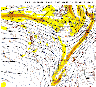
During the next week a major ridge of high pressure will build and hold in place over the eastern Pacific.  Let me show you, using the upper level forecasts at 500hPa, about 18,000 ft above the surface.

The forecast for Thursday at 11 AM, shows a ridge, but a weak short-wave disturbance will bring a few clouds and hold back the temps.  Decent weather in the 60s. 


 By Friday at 5 PM, the disturbance is well through and the ridge is building.  Sunny and low 70s.

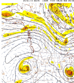
The ridge builds over the weekend over us and a low develops over California--not good for the sun-accustomed folks of southern CA, but a very warm pattern for us due to the easterly flow above the northwest.  80F is NOT out of the question for many of you.
Tuesday morning?   The pattern is holding (see below).   Believe it or not you will become sick of heat and sun!

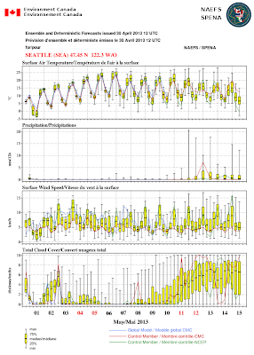
OK, some of you are ready to chide me.  You can't trust one model run!  What do the ensembles (many forecasts made with slightly different starting points or physics) show?   Well, you are right, and below is the output from the North American Ensemble Forecasting System (NAEFS) for Seattle.  The top panel show temperatures (C not F!).  The line in  the middle of the yellow boxes give the median values (half of the simulations are above, half below).  The highest and lowest forecasts are shown with the "wiskers" protruding off the boxes.  Bottom line:  warming, with very little doubt about it during the next five days.

The second panel gives precipitation.  VERY dry in nearly all the ensemble members for the next week or so. 

Right now the National Weather Service downtown Seattle forecast only reaches 69F on Saturday.  I bet they will be bringing this up!  They are a conservative lot down there.

And if your heart needed any more warming, here is the latest 8-14 day temperature forecast from the Climate Prediction Center.   Probabilities weighted for temperatures to be warmer than normal (and needless to say, no precipitation).
As I have said several times in earlier blogs...this spring is not a repeat of the past two.

Want to help find out the effects of coal trains on the local environment?

Atmospheric Chemistry Professor Dan Jaffe is ready to begin a study on air pollution from trains, especially freight  and coal trains, in the Puget Sound region.   Several state and local agencies told him that this work needs to be done, but that it is too politically hot for them to fund.

Considering the importance of this work, Dr. Jaffe is going to depend on crowd funding to support this effort.  For more information and perhaps to help, please check out this website: 

https://www.microryza.com/projects/do-coal-and-diesel-trains-make-for-unhealthy-air

April 27, 2013

The "Pause" in Global Warming: What Does it Mean?

The media mentions it frequently and global warming skeptics talk of little else:  the fact that global atmospheric temperatures have not gone up significantly during the past 10-15 years.

Does this disprove the idea that the planet will warm due to increased CO2 and other greenhouse gases?  Are the global climate models mistaken?  Who are telling the truth:   the skeptics or climate scientists?

My take on all this is that a decade of near-constant temperature does not show a fatal flaw in climate science, but it does reveal poor communication and occasional overhyping by climate scientists.  And some cynical games by skeptics.

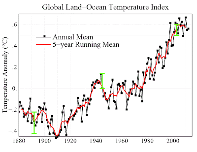
So what is all the debate about?  Here is a plot of global temperature from the NASA Goddard web site, showing the annual mean and 5-year running mean temperatures from 1880 to now (actually it shows the difference...or anomaly...from the average for 1951 to 1980).  Error bars indicated by the green brackets.

Global temperatures fell to about 1910, rose to roughly 1940, leveled off for forty years, rose rapidly from 1980 to roughly 2000 and then have been nearly constant for the past 15 years. The level period during recent years is the "pause" that everyone is debating about.

The fact that temperatures level off for a several years...even a decade or more...is not surprising or exceptional, even if the earth is generally warming due to greenhouse gas increases.  The atmosphere/ocean/cryosphere (ice) system has a number of modes of natural variability--in other words temperatures will vary WITHOUT any "cause" or external forcing.  One example you all know about:  El Nino/La Nina, which causes variations over a period of typically about 7 years.  But there are others.   Over the Pacific basin, there is the Pacific Decadal Oscillation, with a period of about 60 years, while the Atlantic Multidecadal Oscillation (AMO) has a period of about 70 years.   And there are others.

According to most estimates, the forcing (greenhouse gas warming) by humans on the radiation coming into and out of the planet only became appreciable around 1970, and even today natural variability is as large or larger than the human-caused warming signal.   So when natural variability is pushing the atmosphere towards cooling, it can balance the global warming signal, resulting in little change. Or even temporary cooling.


There is another possible contributor to the recent leveling:   the huge increase in particles (aerosols) in the atmosphere associated with the big increase in coal burning and petroleum usage in China.    Such particles can cause cooling both directly (by reflecting solar radiation to space) and indirectly  (by changing the number of cloud droplets).

Satellite measurement of particles in the atmosphere.

Particles from China and other sources could result in cooling that can offset greenhouse-gas warming produced by CO2 from burning fossil fuels.  But quite honestly, we don't have a good handle on the amount of such particles and their impacts, both direct and indirect. We have good reason to believe that such particles result in cooling though.

Some recent articles have speculated that some of the greenhouse gas warming is going into the deep oceans and thus unavailable to heat the atmosphere.  A lot of uncertainty in that hypothesis.

Some of you might ask, quite reasonably, is it possible that some of the warming during the late 20th century was not due to anthropogenic (human-caused) greenhouse warming but was the result of natural variability?   This is surely possible.  In fact, a colleague of mine at the UW,  K. K. Tung, and his associates have written a paper suggesting that some of the recent warming was due a natural mode of variability (the Atlantic Multi-Decadal Oscillation, see graph below).  And an increasing number of studies have suggested that part of the loss of Arctic sea ice was caused by changes in atmospheric circulation, not greenhouse gas warming.   So folks, one really has to be careful here.

 Research by Tung and Zhou suggest that the AMO internal variability (red line) could explain some of the rapid warm up in the late 20th century and the climate pause of the last decade.  It also implies that warming could be delayed a few decades.

So it is quite possible that the recent pause in warming could be traced to some combination of natural variability and particles from China and elsewhere.   And that some of the warming that led to the pause may have been of natural origin.  You don't see this well covered in the popular media.

A pause in the warming is good, but there is no reason to expect it to last more than a few decades.  Cooling from natural variability will be replaced by warming as the natural cycle moves to a warming phase.  And China will eventually have to clean up its act   as it has become clear that the smoke and particles are making life miserable and unhealthy for the Chinese.   And just as important:  mankind's forcing of global warming will  increase as the levels of CO2 and other greenhouse gases increase in the atmosphere. And they will increase, particularly with all the cheap/abundant gas and oil from fracking (see graphic).  Emissions and concentrations of greenhouse gases will continue to rise during this century.

To put it another way, add a relatively constant level of natural variability to an increasing human-caused global warming signal, and eventually global warming will win. 

Many skeptics refuse to acknowledge the basic ideas outlined above and are fixated on the "pause" or the origins of past temperature variations.  That is not the real issue here.  The issue is that human-caused global warming will eventually dominate....and that will happen during the second half of the century.

But, let's face it, some of those believing in the serious nature of global warming have also been confusing the public.  How many times have you seen global warming advocates crow about a single record warm year, heat wave, or a season with less ice in the arctic as clear proof of global warming?  Quite often.  But such transient or brief events could well be mainly the result of natural variability.

Atmospheric scientists should know about natural variability and must be more careful in claiming that short-period extremes mean anything.  And you can see the gamesmanship when they keep quiet about unusual cold periods.

Climate scientists are their own worst enemies when they show the average (or ensembles) of climate models (see below).  Each climate model simulation HAS natural variability (see example below), but when you average them this variability is smoothed out, leaving a steady rise in temperature due to greenhouse gas forcing.  But such a steady rise will never occur in the real world, a real world in which lots of natural variability exists.  So it looks like climate scientists have it all wrong when a period of no warming or cooling occurs for a short period.  Talk about shooting oneself in the foot!

 A collection of climate forecasts using global climate models are not identical due to differing natural variability in each.

And there is another issue.  Most climate models have been "tuned" or calibrated to match the variations in 20th century climate.   All climate models have "knobs" or the ability to change key parameters that are not well understood (like the impacts of particles in the atmosphere), and these knobs are often adjusted to match the known variation and structures of the atmosphere during the historical period with observations.  The trouble is that one can overtune and actually degrade the model's ability to predict the future by doing this.   For example, if a particular model did not get the cooling in the mid-20th century correctly, perhaps because it did not have the phasing of natural variability correct, a "tuning" to make it do better might change the model in a way the undermines its ability to forecast correctly in the 21st century.   Such matters need to be talked about more.  Fortunately, as we learn more about the atmosphere, the need for tuning has declined, but it is still an issue.

Anyway, this climate business is complicated stuff with a lot of subtleties, and folks on both "sides" have been presenting material that could be deceiving.  But the bottom line is still clear, the human-induced warming signal will increase during this century to a point that its significance and importance will be undeniable.  But the magnitude of this change is still uncertain.

April 24, 2013

The Coldest Major League Baseball Game in History?

Some records are so important, so notable,  that even though they didn't occur in the Northwest they deserve mention in this blog.  This is such a record.

On Tuesday, it is highly probable that the coldest major league baseball game in history was played in Denver.   A home game of the Colorado Rockies against Atlanta, the first pitch temperature was 23F, smashing the old record of 28F.


Temperature record keeping from major-league baseball only goes back to 1991, so why am I fairly confident that this is the record that extends back to baseball's early days?   The reason is the location.

Denver is the highest altitude baseball stadium by far: 5183 ft (they don't call Denver the Mile-High City for nothing).  The next highest are Arizona (1080) and Atlanta (1050 ft).    Far lower and much warmer locations.  Higher generally means colder.   Furthermore, being on the eastern slopes of the Rockies, Denver is vulnerable to surges of cold air from the north.   Guess what happened on Tuesday?  Here is the proof:  a surface chart that clearly shows a tongue of high pressure and cold air moving southward down the western side of the high plains.

The result were a large number of daily records in the region, both for minimum and maximum temperatures (see graphics FROM THE U.S. GOVERNMENT below for the proof, blue dots indicate record low).

Record low minimum temperatures

Record low maximum temperatures.

Now here is the good part.  Denver was an expansion team that played its first season in 1993.   Thus, considering its unique meteorological location and altitude, it is quite possible that the 23F would have been the coldest temperature on record for all major league games at any location.  Yes, you might argue about Minnesota, but keep in mind that the baseball season usually starts around April 1, and the all-time record low daily maximum temperature in Minneapolis  for April was 22F in 1896.

The cold air produced all kinds of unusual sights at the game.  Ground fog swirled around the pitcher!  Snow was seen in the outfield (see below).


And snowmen were found in the stands.


With such cold air, the air would have been very dense, working against the long ball.   Perhaps in a future blog I will take on the controversy of cold temperatures at Safeco Field in Seattle...but that will have to wait until another day.


Before another game in Denver

April 23, 2013

The Banana Belt of Brookings, Oregon


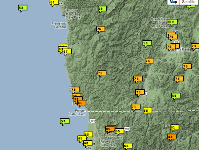
The Pacific Northwest has lots of weather oddities and one of my favorites occurred yesterday at Brookings, Oregon, located on the southern coast of Oregon.  Here are the high temperatures yesterday (Monday) over the Northwest from a National Weather Service summary chart.  Lots of 60s, but wait!  ON THE COAST, right near the California border temperatures jumped to 80F, while temperatures were in the 60s to the north and south!   To an experienced NW weather watcher this means only one thing:  the "Brooking's Effect" has again revealed its power.  There is a reason this area is called the "Banana Belt" of southern Oregon!


A closer-in view reveals more detail (see below).  Low 80s in Brookings and 60s to the north and south along the coast.  70s inland.  What is the origin of this weird effect, one that can brings 70s or higher to the coast near Brookings during ANY MONTH OF THE YEAR?


To understand what is going on, we must start with a terrain map (see below).  There is something unique and special about Brookings:  it is just west of the one location along the coast where high terrain extends all the way from the coast to way inland (known as the Klamath Mountains/Siskiyous).   It also is a place where the coast is oriented SE-NW.


In situations where the winds are from the east or northeast, air descends  the terrain east of Brookings and is compressed as it moves downward.  Compression results in warming.   We know this was happening for many reasons, including the availability of a radiosonde (balloon-lofted weather instrument) upstream at Medford (see below).  This figure show temperature, dew point, and winds from the surface to roughly 10,000 ft (700 is pressure in hPa).  We can see the easterly and northeasterly flow through the layer.

We can also examine the sea level pressure, surface winds, and lower atmosphere temperatures...in this case at 2 PM on Monday using the WRF model forecast (see graphic).   There is a trough of low pressure extending northward into western Oregon, with easterly flow over its northern portions.

We can view the surface temperature forecast from the WRF model (4km resolution), which shows the whiter (warmer)  colors near Brookings and the NE flow near the surface.

Offshore, descending flow not only brings warmth, but very low humidities.  The plot (right panel) below shows that the relative humidity dropped to approximately 10% during the warmest period.  This is because the air was warm (so it could hold lot of water vapor) and because the dew point dropped in the downslope flow.


One final curiosity...while the minimum temperature last night at Brookings was 62, while at Burns in eastern Oregon it dropped to 13F.  Nice to live in a region with some contrasts.

April 21, 2013

Wind, Wildflowers and Warmth


During the spring, the eastern slopes of the Cascades offer a wonderful refuge from the clouds and precipitation west of the Cascade crest, and this time of the year there is a special bonus:  amazing wildflower displays.  But this ideal escape is tempered by one "issue"--at least  in some locations:  strong winds.

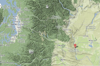
Yesterday, in search of warmth, sun, and wildflowers I headed with some friends to the hills near Vantage, Washington (see map).  Vantage is probably the most dependably warm, sunny location within two hours drive of Seattle during the spring.


During this season, winds aloft are often from the west or northwest, with clouds west and over the Cascades.  Air descends and warms east of the main Cascade crest and then sinks again as it drops down over the final hills west of Vantage.  Descent causes warming and the evaporation of any clouds...and yesterday (Saturday) was a perfect example.   To illustrate, here are two satellite images from about 3 PM Saturday, one from the NWS geostationary satellite and the second from the NASA MODIS high-resolution satellite.


Classic spring satellite image.  Western Washington engulfed in clouds except for two clear zones downstream of Vancouver Is and the Olympics.  But cross the Cascade crest and descend the slopes and the skies opened up.  You can see low -evel lee wave clouds just east of the Cascades crest (those north-south linear features) and if you look carefully you will see streams of high level clouds stretching to the SE away from the Cascades....they are associated with high level mountain waves produced by the Cascades.

Driving across the Cascades around 10 AM we hit a wall of clouds, fog, and rain, which began to lessen east of the crest around Easton.  By Cle Elum the rain was over and the skies brightened, while by Ellensburg sun was starting to break through.  But it was the descent along the terrain down to Vantage that brought what we were looking for:  bright sun and temperatures that climbed into the lower to mid 60s.

As we unloaded our mountain bikes at a location a few miles north of Vantage, it became apparent that the sun had some competition for our attention:  strong winds.  Spring is the windy season east of the Cascade crest, particularly in situation like Saturday's, with cooler air and high pressure west of the Cascades and lower pressure to the east.  This pressure difference can produce strong westerly winds particularly downwind of weaknesses or gaps in the Cascades, such as the "Stampede Gap" west of Ellensburg.  The UW high-resolution model forecast for 11 AM on Saturday showed such strong winds, particularly over the hills NW of Vantage (see graphic).  In fact, the predicted winds were REALLY strong (gusts to 50 knots), but I chose to go anyway....a Northwest version of storm chasing!

As we ascended the rough dirt road, the winds increased, particularly when we were downstream of westward, directed canyons.   Biking was difficult at times--our bikes were being pushed over by the winds and sometimes we had to walk.   I estimated that we had sustained 30-40 mph, with gusts to 50+ in places.  It got pretty wild.  Here is a video that gives you a taste of what it was like:


But then there were the wildflowers, which my friend Wendell Brown tells me peak in that area during late April.  Fields of white and yellow flowers.   And best of all, perhaps, was a flowering cactus  (see photo at top of blog).


Your blog author, picture courtesy of Wendel Brown


April 18, 2013

Summer in April

Warm, dry weather will be returning next week, with temperatures climbing to near 70F by Wednesday.   The models have been going for a major warm spell for a while and now there is little doubt it will happen.  But first we need to get through the next few days.

During the next 48-h, a few weak troughs in westerly flow will move through (see upper level--500 hPa--chart for Friday afternoon).    The result will be fairly substantial precipitation over the


mountains during the period, with lesser values over the western lowlands (and even less east of the Cascade crest).  Take a look at the 48-h precipitation ending 5 PM on Saturday.  2-5 inches over the western slopes of the Cascades, but little along the eastern slopes of the Cascades.  Snow in the higher passes.  Also notice that Kitsap is relatively dry...the result of descent off the Olympics.

Sunday is the transition day--the beginning of the drying and warming.  By Monday morning, the upper trough is way to our east and substantial ridging has developed over the eastern Pacific (see map).  Get your sunglasses!  Stock up on plants and fertilizer.

 By Wednesday morning the ridge has amplified...this will bring warming temperatures and sunny skies.


The ridge strengthens further by 5 PM on Thursday (see below).  You don't need to be a meteorologist to know what this means.

 The implications of these forecasts is that precipitation will end for most of you by mid-day Sunday and skies will clear.  Temperatures will edge up into the lower 60s on Monday to upper 60s to low 70s on Wednesday and Thursday.   I checked the the gold-standard European Center forecast for Thursday at 5 PM---same story.  Here is the surface air temperature prediction from the EC. It is going for 68-75 over the western lowlands and warmer in the Willamette Valley and parts of eastern WA.


And if that is not exciting enough, take a look at the 8-14 day temperature forecast from the Climate Prediction Center.   High probability of above normal temperatures over the entire western U.S.

To repeat something I have said before in this blog...this spring does not look like a repeat of the past two, which were cold and wet.   We are enjoying a fairly normal spring...for a change.


April 16, 2013

A Bubbling Atmosphere

Today was a spectacular example of how the atmosphere can go unstable over a broad region, bubbling up into convective clouds and showers as the earth warms.   As I mentioned in an earlier blog, when there is a large difference in temperature in the vertical the atmosphere can start to convect...just like in your hot cereal saucepan.  The action was particularly clear over eastern Washington today.

Let's look at the satellite imagery to see this happen from space. At 8:45 AM, western Washington and the coast experienced fog and low clouds, while most of eastern Washington was clear.  With a cool surface and lower atmosphere, there was no convection.

By noon, as the ground was warming rapidly, lots of convective clouds had formed, aligned in what is known as "streets."

By 2:30 PM, the transformation was complete, east of the Cascades was a vast ocean of convection, and some convection had built up away from the water over western Washington (cool water is bad for the convective business since it works against getting a large change of temperature with height).

 4 PM is pretty similar.
And at 7 PM, as the ground began to cool, the convection started to die.


Over eastern Washington the convection did not lay down much rain, but some of the western Washington showers provided a few downpours.  Most of this convection was fairly shallow (less than 10,000 ft high), but could produce some modest bumps coming into or out of  a few airports.  The pilot report (PIREP)  at 10:45 AM at Fairchild AFB outside of Spokane confirmed this.

SKA UA /OV GEG235020/TM 1745/FLUNKN/TP DH8D/TB LGT BLO 060

Finally,  it would like to see a wonderful video of the atmosphere going from stable (low clouds and fog) to unstable (convective clouds and showers), check out this video from the top of my building today (click on image or link):

http://www.atmos.washington.edu/~ovens/loops/wxloop.cgi?/home/disk/data/images/webcam2/20130416+2013041623/23h/10m+-pat+YYYYMMDDHHNNSS.jpg

Convection is a sign of spring around here, just like hay fever and mowing your lawn.

Tomorrow's Windstorm in Four Acts

 Each atmospheric "play" is different and according to high-resolution forecast models, I can describe the four "acts" t...